Explore NSW
Gallery14
This article was first published in the June 2011 issue of 4x4 Australia.
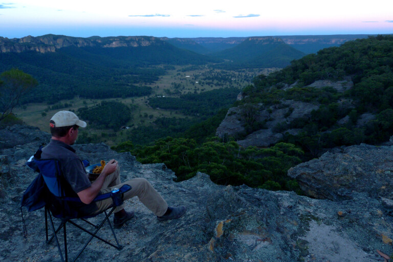
The spag bol wasn’t half bad, but the view was worth five stars.
No wonder I kept coming back here for dinner. It wasn’t a restaurant, just one of the most perfect outdoor settings you’d find anywhere. It was BYO chair, tea, beer, kitchen and bed; the only luxuries on offer being the outlook, the weather and the serenity. All within an easy drive from Sydney.
MOREExplore NSW
I’d set up camp along the cliff tops overlooking the Wolgan Valley. Donkey Mountain sat centre stage, its skirt of sandstone glowing in the setting sun. Somewhere on the other side was the Glow Worm Tunnel. Black dots that were cattle moved on the farmland 500 metres below. It was beautiful, yet I was so close to the city.
14
The forests, tracks, historic sites and rugged geography north of Lithgow, NSW, make an ideal overnight escape from Sydney’s rat-race, and you can do some of it in a single day if time’s tight.
Begin at either the Zig Zag Railway, a historic bit of track by Bells Line of Road with old trains you can ride, or in Lithgow, by going out past the State Gully Mine, which is sometimes open for visitors to explore (a few artists still use the forges in the workshop, too). Either way, the roads converge and head north past Bungleboori picnic grounds, where trail bikers congregate on weekends.
Take a right there and the road leads you to the Glow Worm Tunnel, a disused rail tunnel you can walk through – but try not to disturb the fragile little worms which dot the otherwise pitch-black walls. This road’s a dead end, so you backtrack to the picnic area and then drive west along Blackfellows Hand Rd. Don’t veer right on Sunnyside Ridge Rd, another dead end, although there is a nice view out there if you do.
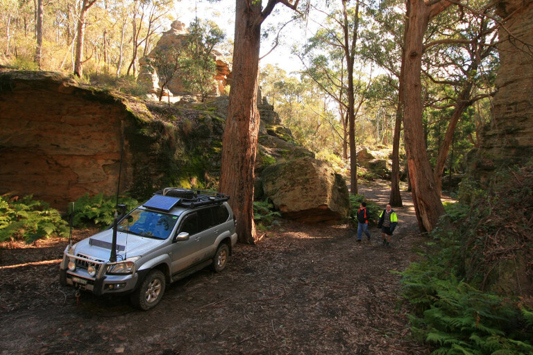
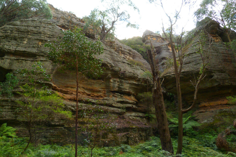
Blackfellows Hand Rd descends into a magical canyon. You can turn right into it and park there, then wander up between the rock walls. Even on hot days, it’s often cool and fresh down there.
This track ends when you hit Wolgan Rd’s tarmac. Newnes is up this road to the north, its remnants a reminder of the days of shale-oil mining a hundred-odd years ago. You can spend the night camped up there in pretty surrounds.
14
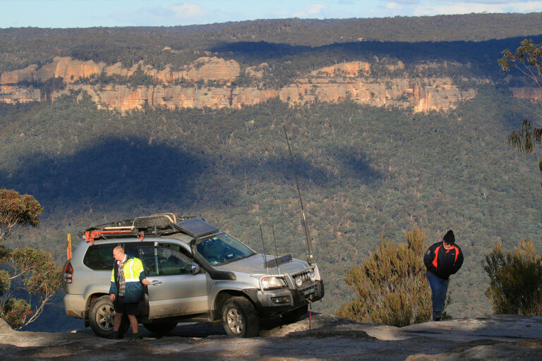
But if you dog-leg about 20m north across Wolgan Rd and head up the dirt track into the bush (it’s been moved recently, so maps and GPS units try to send you a little further south), you’ll climb up the Great Dividing Range in Ben Bullen State Forest. Earlier, you’ll have seen the towers of sandstone that give Gardens of Stone National Park its name, but now they are more common and pronounced.
A few kays up this track, the bush suddenly opens up onto a rock platform and the cliffs overlooking Wolgan Valley. It’s worth a stop and a photo – one of the few places you can snap your fourby at an outlook without fences and barriers to spoil the happy snap.
14
I camped further along here, after taking an unmarked right turn that leads to a high sandstone spit (33°14.897S, 150°07.073E). It’s nice on a still evening but exposed and, at 1000m high, cold if the weather’s wrong. Then it might be best to head on to Baal Bone campground, down in a valley beside a picturesque swamp.
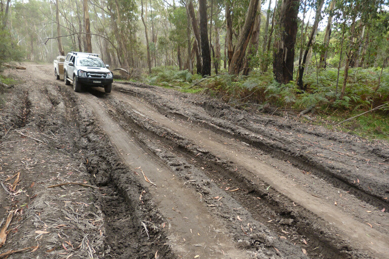
There’s a steep drop into a beautiful canyon on the way, where you’ll want to pick your line. And if you’re coming from the other end, the climb may be a challenge unless the track’s been repaired recently.
Without diff locks, and towing a camper trailer, I barely made it, and then only after a lot of struggle, thought and planning.
Just up from the camping area, the road has been closed at Baal Bone Gap and now forms a bushwalk along Crowns Creek, past Pantoney’s Crown and towards Glen Davis. To continue the drive, go north-west along Moffitt Trail. You’ll finally reach Gardens of Stone NP proper, although you’ll have seen many spectacular and interesting rock formations already.
The driving ends at the Castlereagh Hwy at Ben Bullen. Turn left and you’ll be back in Lithgow in 20 minutes or so, feeling like you’ve been a thousand miles from the big smoke.
14
Travel planner
GETTING THERE
From Sydney, turn off Bells Line of Road at the Zig Zag Railway, cross the lines and you’re away. From Lithgow, find State Gully Mine Rd and head into the hills. From the north, enter along Hutchinsons Rd where the Castlereagh Hwy crosses the railway at Ben Bullen. Wolgan Rd, from Lidsdale to Newnes, bisects our trip.
WHEN TO VISIT
All year, but of course walking isn’t much fun in mid-summer, and it’s below zero overnight in winter.
ROAD CONDITIONS
Mostly good tracks with some rough sections, but there are a few short, sometimes difficult climbs which require low-range. Some parts get boggy after rain. Mine subsidence in the area can make some bogholes interesting.
FACILITIES
No-frills camping at Baal Bone Campground. Camping, fireplaces, toilets and tables at Bungleboori picnic area in Newnes State Forest. Picnic tables at the Glow Worm Tunnel. Expansive camping area, toilets and fireplaces at Newnes.
SUPPLIES
Lithgow has everything, Lidsdale has a servo with basic supplies, and Newnes and Ben Bullen have nothing.
CONTACTS
Lithgow visitors information centre, 1300 760 276 or 02 6350 3230.
National parks info: http://www.nationalparks.nsw.gov.au/visit-a-park/parks/gardens-of-stone-national-park
MAPS
Hema’s NSW 4WD Top 50 Atlas & Guide specifically covers part of this trip in words and, in maps, all of it.
Please enable JavaScript to view the comments powered by Disqus.
COMMENTS