Explore NSW
Gallery13
Mid-western NSW is jam-packed with history, holiday destinations and great camping.
On a recent trip we decided to explore several areas of interest that included traversing the Barraba Track to Mount Kaputar, Pilliga Forest and down to the wonderful Warrumbungles. We knew that by heading west from our east-coast base in winter it would get rather cool, but that just added to the excitement.
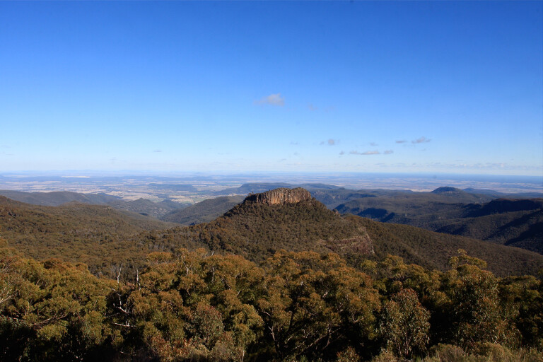
Mt Kaputar National Park is part of a geological skeleton of a once-active volcano. These rock ramparts rise to the Nandewar Range and provide a picturesque backdrop for the residents of, and visitors to, the North Western Slopes and Plains. The Nandewar Range forms remnants of a large volcanic complex built up by repeated eruptions during the Miocene Epoch, between 23 million and 16 million years ago.
13
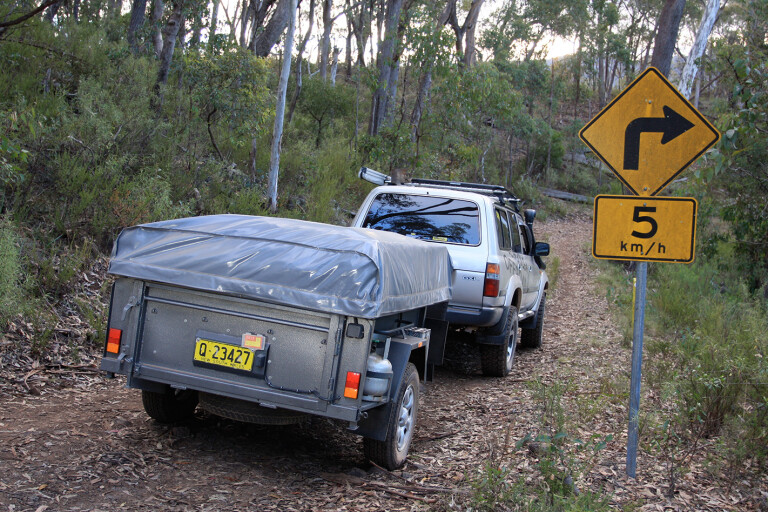
Instead of heading along the well-travelled roads towards Mt Kaputar, we decided to wheel along a little-known track from Barraba to Kaputar’s summit. The Barraba Track is locked and only eight 4X4s each week are allowed to traverse this route. While there is nothing hard about the track, you do need a 4X4 with reasonable ground clearance and you need to adhere to the conditions. The track reaches 1510m above sea level, so it only takes a small amount rain or snow for the route to be closed.
Barraba, a quaint little town with basic facilities, once bustled amid a host of mineral mines, but now it is a quiet western NSW outpost. After obtaining the gate key and some local information regarding track conditions we headed 45km west from town. Along the way we passed through established working properties and a few hobby farms via sealed and unsealed roads.
Entry to Mount Kaputar NP is via a gate, which isn’t locked, but signs inform you of basic park information and regulations. It was evident, even from here, that this was volcano country, with deep red soil and thick undergrowth that seems to thrive in these conditions. Starting at about 400m above sea level and at the base of the mountain, the road surface can be rocky but, by if you select low-range, it won’t be a problem for most 4X4s.
13
The 51,000ha park has been classified as a wilderness area, and it’s easy to see why. The park is also home to various endangered and vulnerable plants and animals. Every corner of the track seemed to give way to a new selection of greenery, from old-growth forests, valleys of grass trees to some of the westernmost rainforest in NSW.
While the track is only 8.5km long we allowed an hour for the journey to give us ample time to soak up the experience. A great stopping point is Brushy Mountain Picnic Area, about 4km along the track. It’s basic but includes a drop toilet and barbecue facilities.
Brushy Mountain had the first of the locked gates and the only way in was with our designated NPWS key – the gates are large and obvious in their purpose.
Between the two locked gates was a 4.5km drive; we found this section interesting with sharp rises and falls along the way, narrow pinches and corners signposted at 5km/h – it would pose a challenge to meet another 4X4 coming the opposite way.
13
Climbing to 1510m, we noticed a change in the foliage; huge gums dominated and sub-alpine vegetation lined the road. We felt the air cool dramatically as we finally found the last locked gate close to the summit.
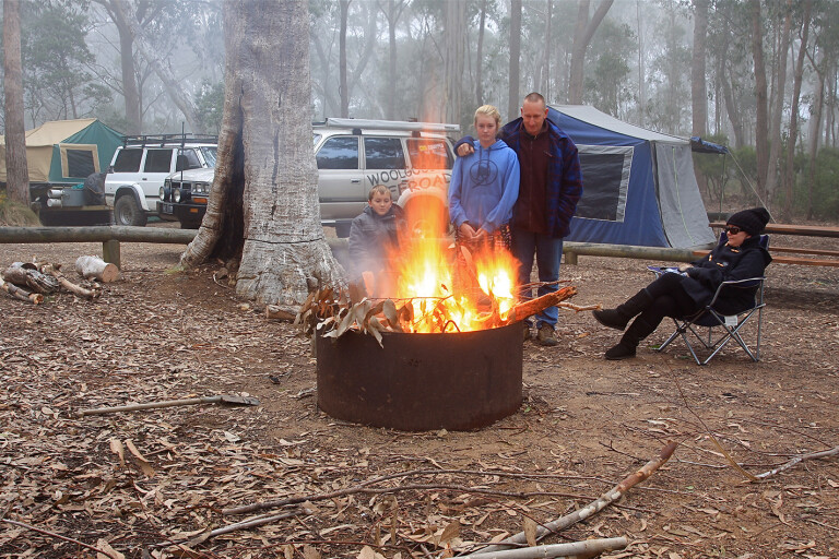
There are a few camping options from which to pick in the park. We chose Dawson Springs. It is the highest camping area in Kaputar and has great facilities with hot showers, toilets and large fire bins.
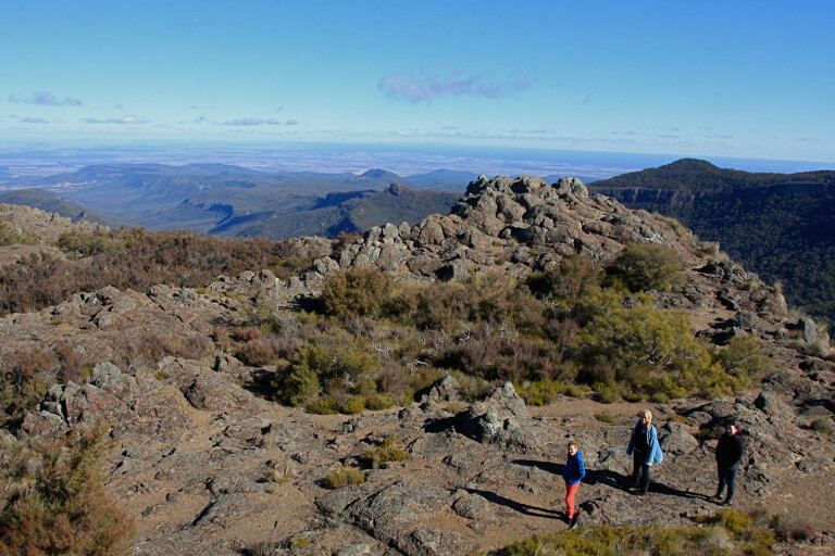
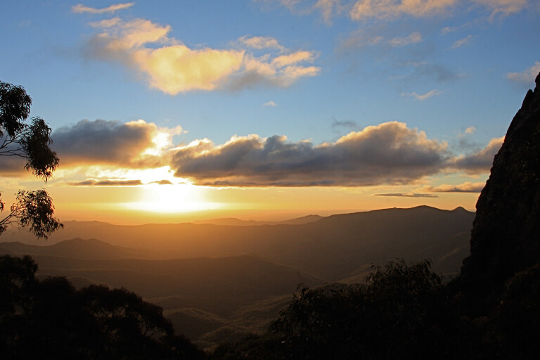
Dawson Springs is well set out for travellers with tents, camper-trailers or day visitors exploring the area. After we set up camp we headed out to explore the local walks and discover the park’s stunning views and history. At the summit of Mt Kaputar we were surprised with the amount of ice that was still falling from the trees despite it being the afternoon. Once our focus shifted we looked beyond to stunningly clear views across the plains below.
Walking tracks in the park range from mild to wild, and there are lookouts close to the road that offer wheelchair access. The Governor Walk is a great track to explore for those with at least some level of fitness. This two-kilometre walk leads to a large volcanic plug where you have uninterrupted views across the landscape below. Be warned though – there are sections where you pass exposed cliff edges; it’s worth the effort but be vigilant, especially with children.
13
With these walks under our belt it was now time to kick back around camp and utilise the large fire bins provided. Remember: this is a national park so you need to bring your own firewood. Winter nights are extremely cold here. With the wind-chill factor, expect temperatures to drop below zero regularly, and don’t be surprised at the fog that rolls in early in the evening.
Early the next morning, it was surprising to see wallabies and birds cruising the campsites looking for scraps from the previous night. Let them scavenge, but be aware that intentionally feeding the animals is discouraged as it upsets their natural digestive system.
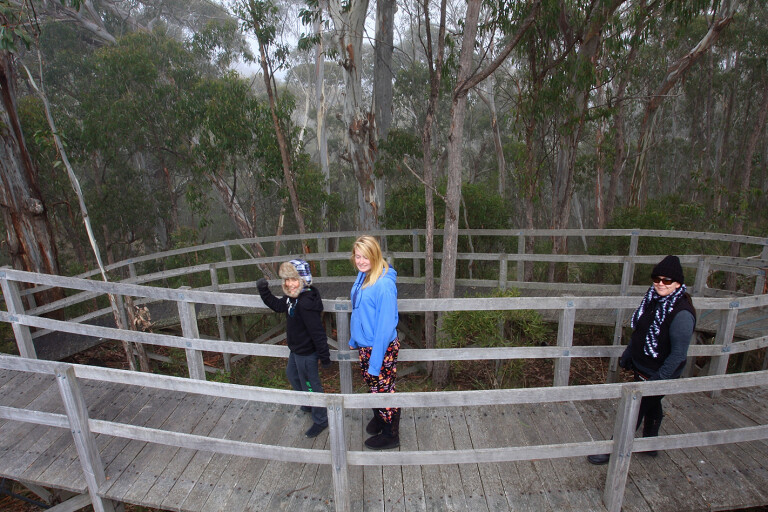
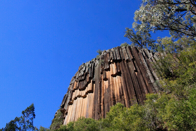
The northern side is another great section of the park to explore. It’s where you will find Sawn Rocks, one of Australia’s best examples of the geology formation known as ‘organ pipes’. To access Sawn Rocks, you need to leave the main part of the park and trek across to nearby Narrabri, before heading along the Bingara Road for 35km. No camping is allowed at Sawn Rocks, but the facilities here are top-class, with free barbecues, toilets and a sealed walkway that allows easy access.
If you’re feeling energetic enough you can follow the formed stairs down into the lower gorge to explore the horizontal polygonal structures or fallen rocks in the Bobbiwaa Creek bed. The 40-metre-high cliff face is the sheared-off remains of a basalt lava flow from the Nandewar volcano which dominated the area 21 million years ago. When the molten rock with the basalt lava flow cooled slowly and, importantly, evenly, this enabled the individual crystals within the molten rock to align perfectly with each other. These rocks formations are well worth the drive.
13
Sawn Rocks is an area in which you can easily lose an hour or two with the walk and lunch, but our destination was further west towards the Pilliga Forest. Heading back into Narrabri and restocking with food and fuel, the road westward soon beckoned us. The Kamilaroi Highway, a narrow sealed road, follows the Namoi River towards the rich cotton-growing area of Wee Waa. Wee Waa can be translated from its Aboriginal language origins as ‘fire for roasting’, and it was the first town on the Namoi River; squatters settled in the area in 1837. The birthplace of Australia’s modern cotton industry, Wee Waa relies on the rich soils and nutrients derived from the volcanic spewings of Mount Kaputar.
We were lucky enough to pass through Wee Waa during the cotton harvest. The kids thought it was great to learn where cotton comes from and how it is processed. Judging by the amount of cotton beside the local roads, it had been a great season. Wee Waa has a friendly population of about 2000 people and has basic facilities.
Our next destination was Pilliga, 56km west of Wee Waa. It is, in fact, approachable from five directions, four of them on dirt roads, but the road from Wee Waa to Pilliga is sealed.
The Pilliga community has set aside several acres of land just out of town for free camping. We were pleasantly surprised as we pulled in; it has hot artesian bore baths (sunk in 1902), toilets, showers and fully grassed grounds. It seemed everyone was here for the same reason – to experience the hot baths that reportedly have a therapeutic effect. We can say that the warm baths were a welcome sight after the cool nights at Mt Kaputar.
13
Fires are allowed here but again, it’s BYO firewood. Luckily, we found a local who occasionally brings in trailer-loads of firewood for a gold-coin donation – how good are country folk!? From the campground there is a two-kilometre walk around the surrounding wetlands. If you are lucky you might see a host of birdlife, from emus, kites, ibis, diverse types of robins to willy wagtails.
Out here you get the real sense of being outback. Enjoy cool clear nights where the star trails seem to hit the ground, stunning sunrises and sunsets, spotting satellites as they track across the sky and breathing that fresh country air.
TRAVEL PLANNER
GETTING THERE
Mount Kaputar National Park is in mid-western NSW, 66km east of Narrabri. The Pilliga Forest and camping area are 100km west of Narrabri. The Barraba Track starts just west of Barraba and a key is needed for this route.
CAMPING
There are camping areas at Dawson Springs and Bark Hut. These areas have toilets, showers and fire pits. National Park fees of $5 per adult and $3 per child per night apply. Pilliga has a free camping area which has hot springs, basic toilets and showers and fires are permitted. No dogs or generators at Mt Kaputar, but they are allowed at Pilliga.
WHAT TO TAKE
You need to be self-sufficient with food, water, spare supplies and firewood. Bins are provided at both locations. Winters are bitterly cold and temperatures often fall below zero so be well prepared.
SUPPLIES & FACILITIES
The nearest major town, Narrabri, has large supermarkets, mechanical workshops and main facilities. Barraba has basic facilities from fuel to food.
TRIP STANDARD
The road into Mt Kaputar has 26km of unsealed road, which is narrow and steep in sections, with another 30km that’s sealed until the highest point in the park. These roads are subject to closures in heavy rain or snow. The road is not suitable for caravans. Pilliga camping area is suitable for all types of camping, and is sealed to the entry. The Barraba Track is 4X4-only and is subject to closure due to snow or rain.
PERMITS
No permits are needed but camping fees are payable at Mt Kaputar NP.
Please enable JavaScript to view the comments powered by Disqus.
COMMENTS