Explore NSW

Gallery12
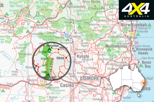
The picturesque Richmond Range in north-east NSW is home to some of Australia’s most spellbinding rainforest scenery.
This feature was originally published in 4x4 Australia’s July 2011 issue
Covering an area of around 40,000ha, the region was all state forest up until 1995, when two new national parks were formed to protect biodiversity of the forest and its amazing wildlife. Toonumbar National Park (NP) at the northern end of the range protects just over 15,000ha of land, while the adjoining Richmond Range NP protects about the same area to the south.
 Although the range was heavily logged for many years, most of the forest is in remarkably good condition. Three small sections that were designated flora reserves in the old state forest due to their pristine rainforest are now part of the World Heritage Listed rainforests of northern NSW and offer fantastic bushwalking opportunities.
Visiting these parks is an ideal weekend trip for anyone from south-east Queensland or north-east NSW.
Using the small city of Casino as a base, head west along the Bruxner Highway for 37 kilometres until you see the turn-off to Richmond Range on the right. For the first 6km the narrow dirt road winds along the top of the range through lush green pastures used for cattle grazing.
Once you hit the boundary of the national park you enter tall forests of spotted gum, blackbutt and tallowwood with a wattle understory. Bird life in these eucalypt forests is prolific and if you stop for a few minutes you will hear the melodious calls from a number of species echoing through the canopy.
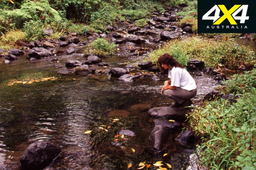
It’s 6km from the park boundary to the Cambridge Plateau picnic area. This is a pleasant spot to take a break and go for a walk on the 2.5km Culmaran Valley track that winds its way through dense World Heritage Listed rainforest.
 Many of the huge forest giants growing here are hundreds of years old and festooned with lianas, orchids, birds-nest ferns and elkhorns. The track can be slippery in places, so be sure to wear reasonable hiking shoes for the walk.
Heading north, the road meanders through a mixture of rainforest and eucalypt forest for another 20.5km until you arrive at an intersection where you can turn left to Peacock Creek camping area or right towards Toonumbar Dam and Toonumbar National Park. Make sure you stop on the way and check out Old Spotty, a magnificent 300-year-old spotted gum that dwarfs most of the other trees around it. The tree is located on the left side of the road about 12km from Cambridge Plateau.
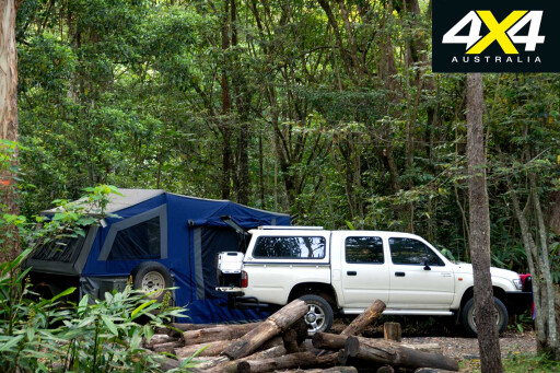
You can either camp at Peacock Creek, a peaceful open grassy area 2.5km west of the intersection or head north to Toonumbar Dam then on to Iron Pot Creek camping area in Toonumbar NP, which is right in the rainforest.
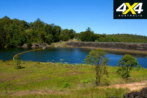 If you decide to go north, turn right and drive about 300m towards Kyogle then take a very sharp left-hand turn onto Iron Pot Creek Road. Follow it for about 8km until you come to a T-intersection with Benns Road where you turn left towards Toonumbar Dam 2km away.
If you’re after a bit of luxury, you might want to stay at Toonumbar Waters Retreat. Surrounded by lush forest and only a stone’s throw from the water, these lovely self-contained cabins cost $110 a night for two people.
From the dam head east towards Kyogle for 7km until you see the sign to Toonumbar NP. Turn left here and drive for a few kilometres before veering right onto Murray Scrub Road which you follow for about 12km until it ends at Iron Pot Creek camping area.
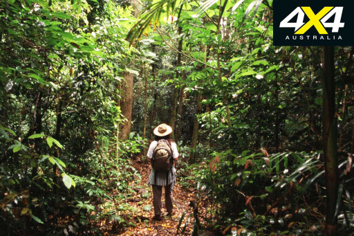
 Make sure you go for a hike through the Murray Scrub, as it is one of the best examples of lowland sub-tropical rainforest in NSW. The 5.5km circuit that winds past huge red cedars, rosewood and teak trees is relatively flat and can be completed in around 3-4 hours.
From the camping area, head 6km back along Murray Scrub Road until the intersection with Coxs Road. Hang a left here and drive up through the pristine rainforest. Don’t attempt it in wet weather since the red soil can become extremely slippery. About 8km along the way you reach a lookout that provides panoramic views over Murray Scrub.
Keep driving up through the forest for another 2km until Coxs Road meets the intersection with Toonumbar Forest Drive. Turn right here and follow the track east through the rainforest for 16.5km to the national park boundary.
From here it’s a steep 4.5km descent through state forest followed by grazing country, until you reach the bitumen on Summerland Way about 6km north of the tiny village of Wiangaree.
MOREExplore
Travel Planner
 WHERE
WHERE
The Richmond Range is north-west of Casino in north-eastern NSW.
CAMPING
Head 37km west along the Bruxner Highway from Casino to access the range.
FACILITIES
Camping costs are $5 per adult per night. Children are $3. For more info call the ranger on 02 6632 0000 or email kyogle@npws.nsw.gov.au.
OTHER INFO
Toonumbar Waters Retreat: contact the resident managers Annabelle and Paul Studders on 02 6633 9140.
WHAT TO BRING
Food and drinking water.
MAPS
Hema North-East NSW is ideal.
PERMITS
No permits are required.
Please enable JavaScript to view the comments powered by Disqus.
COMMENTS