Explore TAS
Gallery14
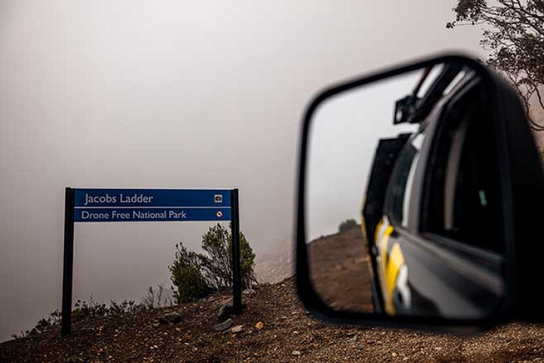
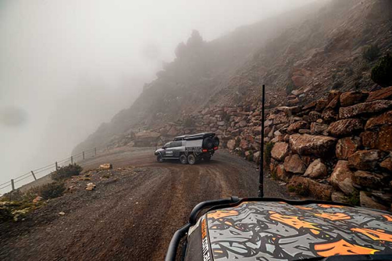
OUR TRIP had not started well. We were on top of Jacobs Ladder ... or at least that was what the sign said … when we were close enough to see it!
MOREEpisode 1
MOREEpisode 2
MOREEpisode 3
We could have been anywhere, I guess, as the thick cloud that swirled around us limited visibility to just a few metres. Occasionally a wind gust would blow in a thinner patch of heavenly moisture and we would catch a glimpse of craggy rock faces above us, or the beginnings of a rugged valley below.
Then all would vanish in another billow of grey matter and we were back to wondering where the vehicle was that we had just walked away from. We waited for some time for the view to improve before we gave up and headed back down through the switchbacks that the ‘Ladder’ is so well-known for.
14
Originally the only access to the top of the Ben Lomond Plateau was via a rough walking trail from the south and while other walking routes followed, the one and only road to the top of the mountain was cut up the near sheer cliffs in 1963.
Today the route remains narrow, unsealed and with a speed limit of just 30km/h. It also rates on the ‘Dangerous Roads’ website, but they do beat it up quite a bit! Still it is reportedly a pretty impressive drive and from the photos on Instagram and Facebook it looked pretty good – I guess, if nothing else, we have an excuse to go back once again.
MORETackling Climies
While there is a small camping area up on the plateau, we drove off the mountain and descended to a lower level amongst the rolling verdant plains of NE Tassie where we could see more than 50 metres. With such visibility we cruised effortlessly towards Bridport.
Located on the northern coast of Tasmania, Bridport was first settled by Europeans in the 1830s with the town being established 30 years later. Gold and tin discoveries farther inland in the 1870s had the town booming, but when the Scottsdale-Launceston railway bypassed the town in 1889 its economy slumped.
Still by the 1920s and the advent of the affordable motor car, the Ford Model T, Bridport became a tourist resort. That continues today and with a couple of world-class classic links golf courses, its popularity seems assured.
TO THE BEACH
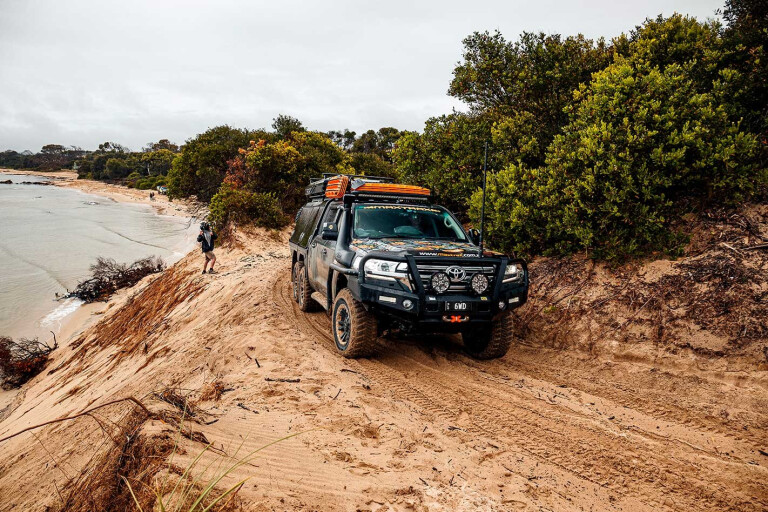
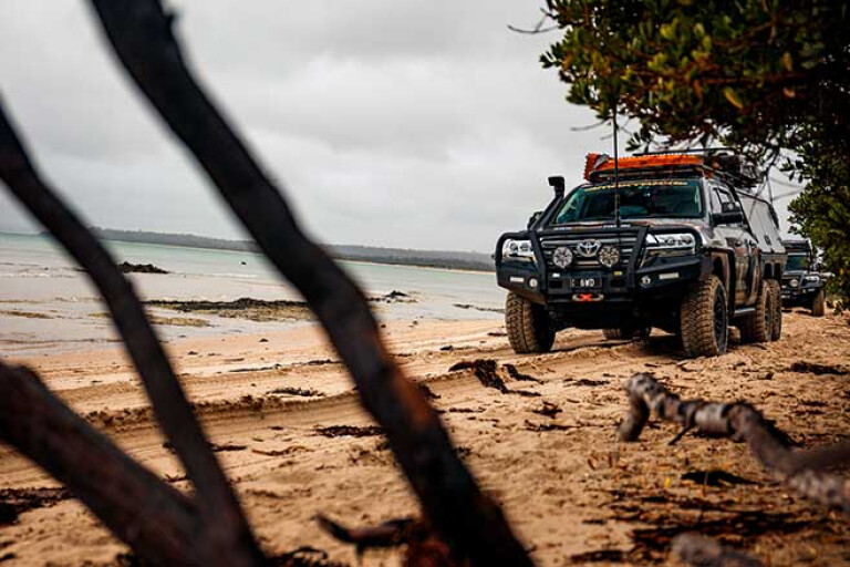
WE HAD COME though, for the beach drive that stretches along the sands and across the headlands between Bridport and Bellingham – just one of the many such drives on this northern coast of Tassie.
The following morning, with light showers of rain and a strong wind, we set off. We dropped tyre pressure and slipped on to the first beach before climbing a dune that had a nasty off-camber turn close to a cliff edge that had us all puckering up in the nether regions and breathing a sigh of relief as soon as we passed the obstacle.
The sand though was pretty benign as the rain had dampened the fine stuff into a firmer base than normal and we cruised through the dunes of East Sandy Point to drop onto the beach of St Albans Bay. The route is marked by orange markers and there are a few no-go areas along the way, designed to protect important seabird and wader-bird habitat, so please stick to the marked route.
14
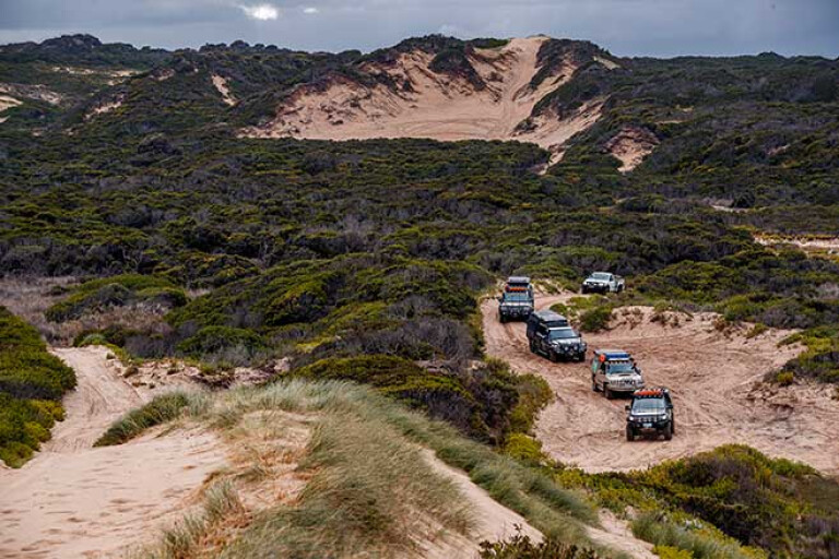
At the far end of the beach there’s a small camping area close to the sea, while the major through-route climbs up onto the sand expanse of West Sandy Point. This large area of tall dunes has long been a playground for 4WD vehicles, buggies and bikes and for those who can’t resist the challenge there’s plenty to test you and your vehicle.
We settled for finding a high, big bare expanse of dune to prop and take a few pics before pushing on, the track dropping onto the beach for the 10km run to the small village of Bellingham.
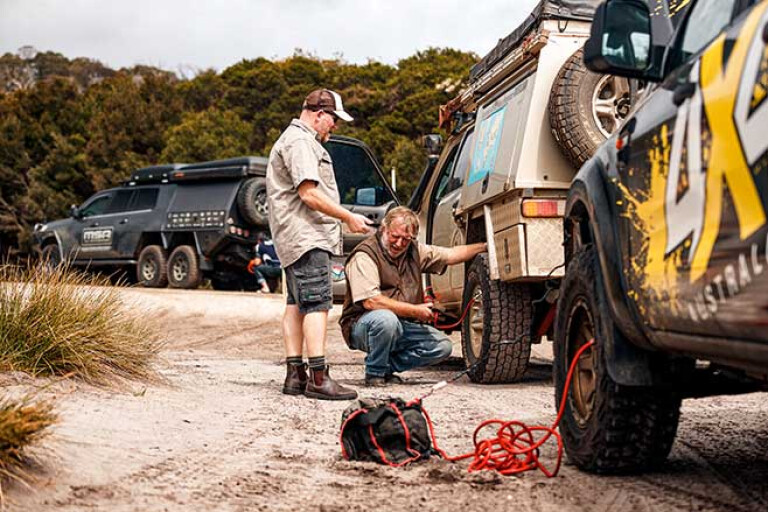
The Little Pipers River, which can be a real trap for the unwary, was nothing more than a trickle and we splashed across it without a care. At high tide or after recent heavy rain the crossing can be very tricky and we got told of a LandCruiser being buried in the sand somewhere nearby, although we saw absolutely no sign of it.
As we climbed on to firm sand we were waved down by a fellow four-wheeler who was stranded nearby – with just a flat battery. In no time we had him started and we were all on our way again.
TRAIL OF THE TIN DRAGON
WITH OUR MORNING warm-up drive behind us we inflated tyres and headed inland, through Derby along what has now been called, ‘The Trail of the Tin Dragon’. This trail runs between Launceston and St Helens and tells the story of the near one thousand Chinese who came to Tasmania in the 1870s to find their fortune in the rich tin mining areas of the north-east.
After stopping in Derby for coffee and lunch – it was again raining – we headed to the historic Moorina cemetery where in one section a Chinese ‘Burning tower’, for the sending of paper prayer scripts to the heavens, had been erected for their customary burial services.
Still, there’s little to remind you these days on how important the township of Moorina was back in the 1880s when it was the main town in the region and an important distribution centre. First named Krushkas Bridge, after the brothers who were the first miners in the region, it later became known as Moorina, after the sister of Truganini, who is often considered to be the last full-blood Tasmanian Aboriginal.
14
Pushing on, we passed through the small village of Weldborough, passing the local pub somewhat reluctantly, which was crowded with locals. Still on the blacktop we passed through the Weldborough Pass Scenic Reserve, notable for its impressive tree ferns which are interspersed with myrtle, sassafras and blackwood, all of which crowd the road in luxurious verdancy.
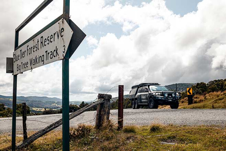
We took to the dirt soon afterwards and found our way to the Blue Tiers, which from 1870 till 1996 produced more than 11,000 tonnes of tin. First proclaimed a Forest Reserve in 1958 the area now protects soje 5000ha of open grasslands, heathland and cool temperate rainforest, dotted with waterfalls and cut by a number of walking and mountain bike trails.
Poimena, where there is now a carpark and info shelter (the road continues a short distance but comes to a dead-end at the start of a walking trail), was once the main town in this rich mining area. However, it wasn’t your normally rip-roaring mining settlement as the one and only pub selling grog was outnumbered by two tea-totaller temperance hotels, plus the normal buildings you’d find in such a spot: a butchery, blacksmith shop and a number of stores and cottages.
14
Today it’s a picturesque spot and well worth a visit, even if it was cold and windy, like when we were there. From this point a couple of mountain bike trails head off through the bush and across the plains while walking trails, varying in length from 400m to more than 10km, one way, lead through a variety of forest and wildlife habitat. We took the short Goblin Forest Walk which wanders through delightful forest, albeit one that has regrown since the tin mining days.
Just down the hill a few kilometres from Poimena is the walking trail to the historic and impressive Anchor Stamper. In 1880 a vast tin reserve saw the Anchor Mine Company install a 40-head stamper, which increased in size to a 100-head mill, initially driven by a water wheel some 20m in diameter.
It must have been an incredible operation and a noisy one when it was thumping away crushing the rock into fine powder to extract the semi-precious metal. Today, just a few heads of the stamper can be seen, the walk to them taking you through delightful forest dotted here and there with tall tree ferns that help cover the man-made scars that can still be seen by the observant walker.
From there we headed downhill to lower, warmer altitudes to the small spread-out hamlet of Pyengana, the first European settlement, known as St Columba, having been established here in 1875. Today that name is perpetuated in the nearby spectacular 90m high St Columba Falls, that some consider to be Tasmania’s finest waterfall. While the town began in this lush valley as a place to service the mines in the region, it was the rich grass that helps produce high-quality milk and cheese that the place is now famous for.
14
Among other attractions, the community is home to the famous ‘Pub in the Paddock’ and a beer swigging pig or two. Trouble was, when we got there on a Sunday evening the pub was shut, as it does on most Sunday evenings. But this is country and when the owner who was driving past saw us wandering around checking out the pub (and the pig) he came in, opened up and served us a beer or three amongst a chattering of rich repartee.
We didn’t drive far that evening, just a couple of hundred metres to the free camping area set around the footy ground … and it’s a cracker with lots of room, hot showers and all.
That’s what I really enjoy about Tasmania. Distances are generally short and you can be on a challenging beach drive in the morning, have a good coffee in a trendy town like Derby (now the mountain bike capital of Tassie), soak up a bit of history, have a mountain forest drive in the afternoon and be at a great country pub in the evening, all with time to spare.
Next day we headed through the forest on Argonaut Road, dodging a few logging trucks in the process to get to St Helens and a coffee before heading to the Peron Dunes and the beach for a bit more sand-driving fun. The weather had cleared too which made the beach, sand and water even more enjoyable. With a set of Maxtrax we rescued another four-wheeler who had bogged down in the soft sand before departing and heading to places farther south.
FRIENDLY BEACHES
STOPPING AT THE info centre in Freycinet NP we obtained our permit and headed to the Cape Tourville Lighthouse, set on a dramatic bluff above a normally wind-churned sea. The lighthouse though is not a real oldie, only being built in 1971, and replacing an older light on Cape Forestier, nearby. There’s some amazing coastal views around here, but we struggled to stay upright on the boardwalk, the wind threatening to blow us off towards a very distant New Zealand.
14
With the long summer twilight of Tassie well advanced, we headed for a bush camp at the southern shores of the Friendly Beaches. Trouble was we never quite made it with one of the vehicles in our group developing a mechanical issue, so we camped in the forest on a clearing beside the main 4WD track for the night before getting the problem sorted in the morning.
We then headed to the very popular Friendly Beaches carpark and camping area where you could not move, everything being full to the brim. After a quick look around and an envious glance at the white sand and blue water, which the area is famous for, we headed off; the start of another adventure farther south was calling.
TRAVEL PLANNER
There are plenty of opportunities for camping and exploring Tasmania’s East Coast and hinterland. If you’ve got a camper trailer or van, for most of the beach drives I’d leave the camper behind at a suitable spot while for mountain trails I’d be doing the same.
The best guide to 4WD touring/camping in Tassie is, 4WD Tracks in Tasmania, by Chris Boden.
Ben Lomond NP (Jacobs Ladder)
Blue Tiers Forest Reserve
Pub in a Paddock – Pyengana: Phone: (03) 6373 6121
Peron Dunes
Freycinet National Park
Please enable JavaScript to view the comments powered by Disqus.
COMMENTS