Electronics & Gadgets
Gallery1
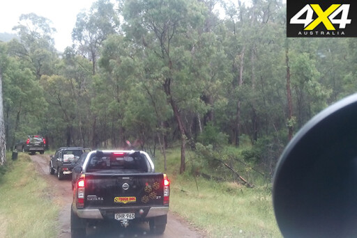
AFTER raving about the Hema Explorer app I ran on my iPhone on the recent ARB Off Road Icons trip across the Simpson Desert, 4X4 Australia editor Mat Raudonikis suggested I give the new Hema HX-1 Navigator a run on the 4X4 Of The Year test through the Victorian High Country.
WHAT IS IT?
THE HX-1 Navigator is Hema’s latest sat-nav system that offers both on-road voice-guided navigation and off-road navigation, and it’s packed full of fantastic Hema maps as well as a full suite of topographic maps covering all of Australia and New Zealand.
The HX-1 may look similar to its HN7 predecessor, but switch it on and you can immediately see significant improvements. The screen is the same seven-inch size, but it’s much brighter with more vivid colours and a higher resolution, and the touchscreen functionality requires less finger pressure to activate on-screen buttons.
Various other HX-1 physical attributes are similar to the HN7; it’s relatively thin, not too heavy and it attaches to your vehicle’s windscreen via a quality suction cup and solid mount system that exhibits virtually no vibration, even over rough terrain.
DRIVE MODE
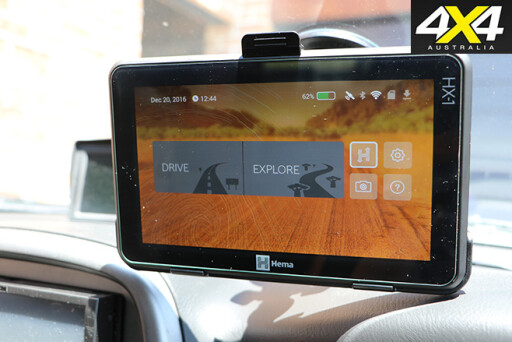
SWITCH the HX-1 Navigator on and you’re presented with a screen offering Drive (on-road navigation) and Explore (off-road navigation) options.
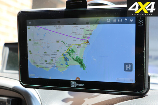
 Select Drive and you have full street mapping for Australia and New Zealand, with easy-to-set destinations, voice guidance, traffic light and speed camera warnings; the latter proving extremely helpful when approaching Melbourne on the M1.
In Drive mode the map screen displays upcoming turns, current road name, speed, speed zones, estimated arrival time, distance to destination and more. There’s also a comprehensive trip computer with information such as speed, altitude, heading, arrival time, trip time and more. Like many sat-nav systems, you can set a number of route options to avoid tolls or motorways and the like, and when setting a destination there are thousands of POIs (Points Of Interest) under sub-categories such as accommodation, auto services, emergency, entertainment, camps and locations, caravan parks, medical, petrol stations and much more. Select a POI and the HX-1 offers a variety of details such as facilities, co-ordinates and contact details.
Once your route has been calculated, you can preview it prior to departure and check out any POIs along the way. You can then alter the route with detours and alternatives, and you can queue up numerous destinations in one route by using the multipoint route feature.
The Drive mode is very easy to use and is packed full of useful features.
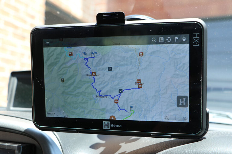
EXPLORE MODE
IF you’re familiar with the Hema Explorer app for Apple or Android devices, it won’t take you long to get your head around using the HX-1 Navigator’s Explore mode. The main map in the Explore mode is the Hema Explorer Map (1:150,000), which includes more than 1.2 million kilometres of 4WD tracks and outback roads. Connect the HX-1 to your Hema online account via Wi-Fi and you can download Hema Explorer maps to a more detailed scale of 1:9000. Additional map sources include digitised Hema touring maps, state government topographic maps, and HERE street, terrain and satellite mapping.
 The Explore mode also has more than 40,000 POIs overlaid on the maps, split into subcategories including accommodation, facility, service, information, supply and my waypoints. Drill down to individual POIs and there’s information such as coordinates, addresses, phone numbers, email addresses, website details as well as facilities where applicable. You can even overlay weather radar information on the map, so you can continually monitor conditions.
Route planning is easy and can be done by either plotting positions on the map point-by-point or by using the quick routing tool, where the HX-1 calculates the optimum route for you.
 Once you’re on your journey you can save traditional waypoints by hitting the ‘flag’ logo on the screen and selecting ‘Create Waypoint Here’ and then adding notes, or you can select ‘Take Picture’ to capture a visual image of the waypoint, as well as add notes. In fact, the HX-1’s camera even allows you to capture video using this function, which makes it easy to record images and sound so you can recall conditions/features at a particular waypoint when reviewing the footage, either on the HX-1 or when you upload the information to your computer.
Recording a track on the HX-1 Navigator.
When you review your route on the map screen, you can select the waypoints you have created and view the images/video/notes, so you have a direct reference to where the shots were taken. Alternatively, you can view all of these waypoints under the timeline accessed through a drop-down menu on the left side of the screen.
On test in the High Country I recorded several still images of varying quality while the HX-1 was mounted to the windscreens of different vehicles, as well as some pretty decent video footage that clearly shows the conditions we encountered on our drive programme.
Water crossing, filmed using the HX-1.
These images/videos are stored either on the device’s inbuilt storage or a MicroSD card, and can be manually transferred to your computer via the supplied USB cable, which is advisable if you wish to hang on to them permanently.
A trip toolbar at the bottom of the screen in the Explore mode displays information such as distance, moving time, total time, co-ordinates, altitude, ascent, max altitude, min altitude and average pace. This information (and more) can also be accessed via the drop-down menu and includes graphs that display altitude and speed profiles over the trip.
SYNCING WITH THE CLOUD
ALL of your trip information (routes, waypoints, photos, etc.) can be synced with your Hema Explorer Cloud account once the HX-1 is connected to Wi-Fi. This can then be shared with friends, family and other Hema explorers. Likewise, you can view the trips recorded by other explorers, and even download them so that you can use them as a route planner for your own adventures.
Snapper Ellen almost falling into the drink.
Once you have synced your trip with your Cloud account, you can view all of the recorded information on your computer, including the map route, waypoints, trip statistics and more. You can also add notes, view different map layers and access driving directions.
Another advantage of Wi-Fi connectivity is that the HX-1 Navigator has wireless updates.
SUMMARY
THE Hema HX-1 Navigator is without a doubt the best sat-nav system I have used, both on- and off-road. It has a great windscreen mount, a bright and vivid display, is easy to use and is preloaded with the best maps on the market.
Great weather for camping.
Additional features such as the still and video camera, and the ability to sync/share trips on the Hema Explorer Cloud, add to the device’s functionality. I also like the fact that you can swap over to Drive mode without interrupting a track recording that’s taking place in Explore mode, so you don’t lose any track data as you navigate around a town.
At $699.99 the Hema HX-1 Navigator is great value for money, and it comes with 4WD map updates for the life of the unit as well as three years’ worth of street map updates. For full specs on the HX-1 check out the website.
Please enable JavaScript to view the comments powered by Disqus.
COMMENTS