Explore

Gallery11
We present the Top 10 4x4 tracks in Australia to put on the bucket list, in no particular order.
With countless 4WD tracks scattered throughout Australia, no doubt we've had to omit a few worthy of this list - so please let us know what we've missed in the comments section below.
JUMP AHEAD
- Binns Track, NT
- Oodnadatta Track, SA
- Canning Stock Route, WA
- Birdsville Track, Queensland
- Madigan Line, NT
- Simpson QAA Line, NT
- Blue Rag Range Track, Victoria
- Border Track, Victoria/SA
- Old Telegraph Track, Queensland
- Climies Track, Tasmania
- State-by-state guide
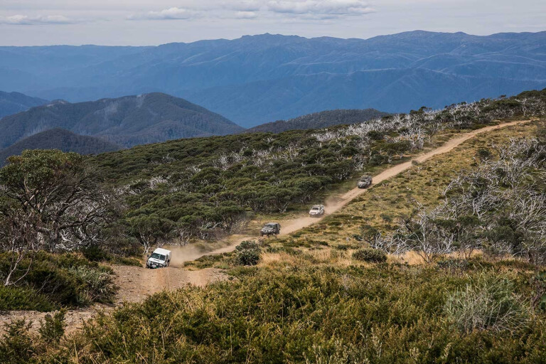
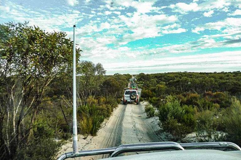
Binns Track, NT
If a Northern Territory adventure is on the agenda, then the famous Binns Track should be at the very top of the itinerary.
Named after Bill Binns, a ranger with 32 years of experience in the NT, the track snakes from the north of South Australia, into Central Australia and then the NT, leading to a number of iconic – and not-so-iconic – spots.
The starting point for the track is at Mount Dare in SA, within the Simpson Desert, which itself is an adventure to reach. Pointing the bullbar north will cross over into the NT, where the Old Andado Road leads to Alice Springs, a poorly maintained route with several (usually dry) river crossings. From here, the track cuts through the East MacDonnell Ranges and works its way further north.
11
There are plenty of turn-offs scattered along the track that lead to many well-known locations including N’Dhala Gorge, Old Andando, the abandoned gold mines at Arltunga, Gemtree, Devils Marbles, the Boxhole Meteorite Crater, Tower Rock and Davenport Range. If tracking south-to-north, the township of Timber Creek in the NT completes the epic trip.
The majority of the track is gravel, with plenty of corrugations to rattle teeth and unsettle vertebrae, so it’s essential to have a 4WD-capable rig, a decent suspension setup, and good off-road/all-terrain tyres.
There are plenty of fuel stops along the route – Mount Dare, Santa Teresa, Alice Springs, Gemtree, Atitjere, Tennant Creek, Daly Waters, Mataranka, Katherine and Timber Creek – but it’s essential to be entirely self-sufficient.
Track length: 2230km
Permits: A Simpson Desert Parks Pass is required to access Mt Dare.
Oodnadatta Track, SA
The Oodnadatta Track isn’t overly difficult, with the dirt road only challenging following an onslaught of rain – and the only real threat, a pierced sidewall from a wayward rock.
This makes it an ideal track for all 4WDers, with plenty to love about the route. Like most outback roads, The Track is usually closed following rain to protect its surface.
The track begins at Marree in the south, a quaint, historically significant town located 589km north of Adelaide in SA. Marree is actually at the junction of the Oodnadatta and the Birdsville Track (another track to make this list). It ends 405km later at Oodnadatta.
11
The track follows the Old Ghan Railway Line, which runs from Adelaide to Alice Springs, and for most of the way is within eyeshot. At about the halfway point between Maree and Oodnadatta you’ll arrive at William Creek, and it’s the perfect spot to refuel and have a feed at the hotel – plus, there’s a well-maintained camping ground.
Lake Eyre is another landmark en route, with the Oodnadatta Track skirting the majestic lake’s southern edge. Lake Eyre is one of the world’s largest internally-draining freshwater systems, and its pink hue is worth stopping for.
Then there’s the famous Pink Roadhouse in Oodnadatta, an ideal spot to end your adventure with air-conditioned cabins, warm showers and a hearty meal on the cards.
Track length: 405km
Permits: Not required
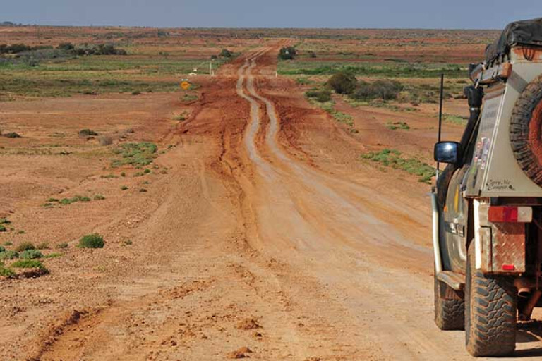
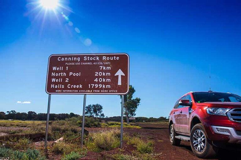
Canning Stock Route, WA
When the topic of Australia’s most famous tracks enters the campfire conversation, there’s one track that’s guaranteed to get a mention: the Canning Stock Route (CSR) in Western Australia.
The tough outback slog isn’t for the fainthearted, with the long-distance journey right up there as one of Australia’s (if not the world’s) most challenging tracks. The remoteness of the track means you’ll need a well-prepared vehicle, with adequate suspension and a tray-full of spares and supplies. Experienced 4x4ers need only apply.
11
Cutting through WA’s vast outback, the CSR runs from Wiluna in the south to Halls Creek in the north and passes through the Gibson, Great Sandy and Tanami deserts. Stretching close to 1800km, the track comprises extremely difficult ruts, as well as hundreds of sand dunes, making it a multi-week adventure.
The start of the track can be reached via Tanami Road from the Bililuna turn-off, and its origins date back to 1910 when it was used to connect 51 wells that watered the stock travelling to market. Stopping at a number of these well-known wells along the way is an essential part of the adventure.
Remember, only travel this route if you have plenty of off-road experience and your vehicle is properly set up. And it’s better to travel with others in a convoy. If you don’t have a buddy willing to join you on the adventure, there are 4WD tours you can sign up to that run throughout the year.
Track length: 1850km
Permits: A CSR permit is required to travel between Wells 5 to 51.
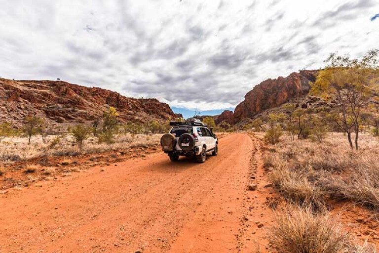
Birdsville Track, Queensland
If you want to tick off an outback 4x4 adventure, the Birdsville Track is an ideal option.
Much like the Oodnadatta Track, the Birdsville Track begins at the small town of Marree in SA. However, unlike the Oodnadatta Track, the Birdsville Track heads in a north-easterly direction towards the famous outback Queensland town of Birdsville.
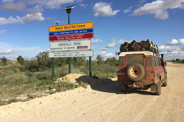
11
Developed way back in the 1860s as a cattle/stock route from Queensland and the NT to Port Augusta, the Birdsville Track has become a popular track for 4x4ers as they head for Birdsville.
Due to the track’s popularity in recent times, it’s not as difficult a trip as it once was; now a graded dirt track where previously only high-clearance 4WDs were recommended. Still, the track runs through some of the driest and most-barren regions of the country, so it’s essential to always carry spare water and to ensure your vehicle is properly prepared.
Track highlights include camping at Kalamurina Station Camping, exploring the Mulka Ruins, and having a brew and warm food at the Mungerannie Hotel. The eastern edge of Lake Eyre is also only a quick detour away.
Track length: 517km
Permits: Not required
Madigan Line, NT
Desert driving is popular with Aussie tourers, with another Simpson Desert track – the Madigan Line – making this list.
The track begins north of Old Andado Station, a cattle station located approximately 360km south-east of Alice Springs, and strikes east into Queensland, eventually meeting up with another track on this list, the QAA Line, to complete your desert exploration.
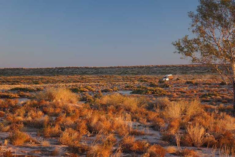
11
As expected, prepare to cross a gauntlet of sand dunes on this trip, and prepare to be challenged. The track should only be attempted by those with plenty of experience 4x4ing on desert sand, as it’s extremely remote and recovery can be very expensive. As always, your 4x4 needs to be tailored for desert exploration
The track was named after Cecil Madigan, who blazed the route through the desert back in 1939 with a convoy of camels. These days, signposted camps along the route make it easier for travellers to find their way – a highlight is Camp 16, were a gum tree blazed by Madigan still stands.
Track length: 500km
Permits: A CLC permit is required to travel the NT section.
Simpson QAA Line, NT
A more challenging Simpson Desert trek is to follow the QAA Line from Big Red near Birdsville all the way to just across the NT border, to the junction of the K1 Line near Poeppel Corner.
We recommend beginning the adventure at Big Red, located just 35km from the popular outback town of Birdsville. Big Red is an iconic 40m-tall sand dune and a worthy adversary of many a four-wheeler – it’s also one of the best spots in the country to watch a sunset. Cresting Big Red as your bullbar points west provides a brilliant view of the desert and countless dunes on the horizon, and where your journey lies.
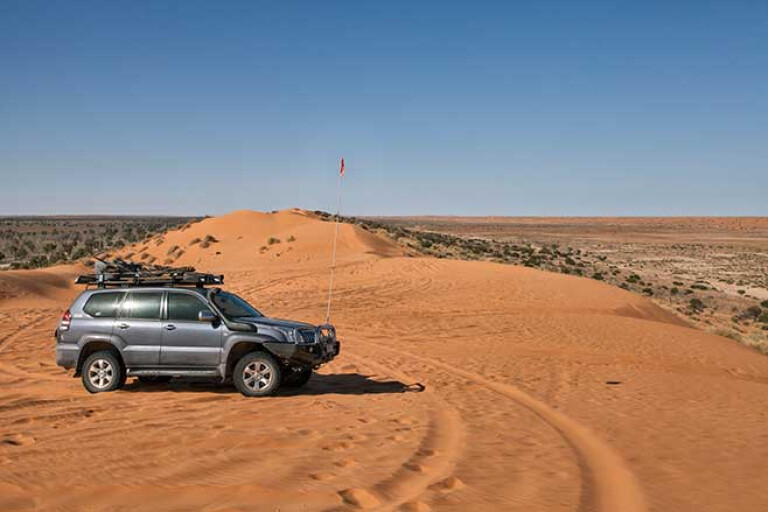
11
The high amount of traffic that utilises this route means the sand dunes are fairly churned up, so it’ll be a chore overcoming the track’s relatively short distance. Ensure your vehicle is adequately prepared – a sand flag is essential – and that you’re entirely self-sufficient.
The challenging, soft tracks are well worth the effort once you set-up camp for the night beneath the wide expanse of stars, with no distractions.
At the junction in the NT, travels through the Simpson Desert can continue via the French Line, the Rig Road and/or the WAA Line, all varying in length and difficulty. The short but challenging QAA Line, in particular, provides a great taste of desert driving.
Track length: 122km
Permits: Camping permit required at Munga-Thirri.
Blue Rag Range Track, Victoria
Arguably one of the most scenic tracks in the Victorian High Country, Blue Rag provides breathtaking views across Alpine National Park.
Rated as a difficult track, a low-range 4x4 with good suspension is non-negotiable. With extremely steep (especially following rain) climbs, tight turns, as well as very steep drop-offs on either side of the track, it’ll definitely get the heart rate ticking. Still, people with off-road experience – and no fear
of heights – shouldn’t encounter too many stressful situations.
11
At 1600m above sea level, snow is prone to fall in the region; hence why the track is subject to closure during the cooler months between May and November. Still, snow has been known to fall outside of these times, so keep an eye on park and track notices.
The track’s greatest challenge is just prior to the highest peak, but it’s this main climb to Mount Blue Rag and its trig point which provides the best photo opportunities.
There’s only one way in and out of the remote track, and that entry point can be found along Dargo High Plains Road between Dargo and Bright. The small town of Bright, about four hours’ drive from Melbourne, is a great base to refuel and prepare for the trip.
Track length: 6.9km each way
Permits: Not required
Border Track, Victoria/SA
The Border Track is aptly named, as certain sections of the route run along the border between Victoria and South Australia.
Your journey to the Border Track can begin in Hopetoun, Victoria, cutting west through Wyperfeld National Park followed by a jaunt through the Big Desert National Park. The Border Track itself begins once you’ve entered the sandy landscape known as the Ngharkat Conservation Park.
11
The Border Track runs through quintessential mallee country, with soft sand typically underfoot – so always remember to air down. The relatively short track – only around 50 clicks or so – encompasses a bounty of challenging driving conditions including a handful of imposing sand dunes. There are chicken routes to bypass some of the steeper dunes, but the track is nonetheless classified as difficult.
To access all the track has to offer, a vehicle with high clearance and low range is essential. It’s also remote country, so have a well set-up rig and appropriate recovery gear.
Track length: 50km (approx.)
Permits: Not required
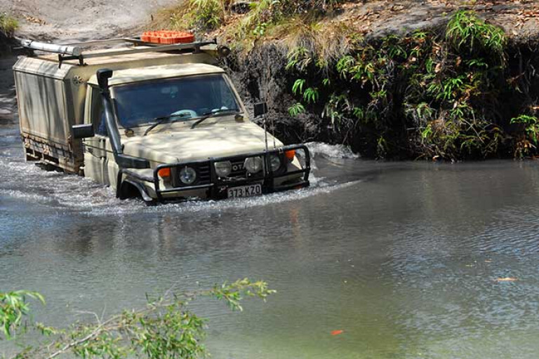
Old Telegraph Track, Queensland
The iconic Old Telegraph Track in Cape York is a no-brainer for this list.
Leading to ‘the tip’, the track is awash with water crossings, slippery terrain and plenty of spots to get stuck axles deep. While arguably not as challenging as Cape York’s Old Coach Road, the OTT is not without risk.
With limited passing opportunities, travelling in a northerly direction is the popular choice. It’s not advised to travel the route in a southerly direction, although it is possible.
11
Perhaps the most memorable section of the track is the infamous Gunshot Creek, located just past the crossing of the Bertie River. No doubt you’ve seen countless photos of 4x4s sliding over the steep drop, which will undeniably get the sweat glands pumping.
The going doesn’t get much easier farther north either, with the northern section of the OTT considerably more challenging than the southern stint. However, there are bypass routes if you’re not up to the challenge.
Another must-do is to camp on the river at the Jardine National Park. But remember, this is croc country, so only swim in places that have been designated safe to do so.
Still, the area’s many waterholes make the OTT and Cape York a cornerstone of Australian 4x4 expedition.
Track length: 350km
Permits: Permit required to camp in Jardine River National Park at the Jardine River and Eliot Falls sites.
Climies Track, Tasmania
Climies Track, on the wild west coast of Tasmania, is an ocean-side track littered with difficult obstacles.
With deep ruts, scrambly climbs, knee-deep mud and deep water crossings, it requires precise wheel control to be beaten. Hence why it’s recommended for highly experienced steerers only.
A capable 4x4 with low-range is a requirement, as well as appropriate rubber. Also, it’s a smart move to travel with friends, as you’ll need some winch support more than once to get out of trouble.
11
The rewards are well worth it, though, with a sense of accomplishment accompanied by trance-like views overlooking the freezing blue seas washing in from Antarctica.
The northern end of the track can be reached via Granville Harbour Road, which is about 26km from the town of Zeehan. The track’s southern end can be reached en route to Zeehan, by taking the turnoff onto Trial Harbour Road.
The track was once used as a major route between two shack towns at Granville Harbour and Trial Harbour, but neglect has resulted in a twisted maze of deep gullies and wild boulders the size of cars.
Climies is an unforgiving track, and its 20km length can take more than 10 hours – so be prepared to be in for the long haul if you want to tick it off the bucket list.
Track length: 20km
Permits: Not required
Explore by state


Please enable JavaScript to view the comments powered by Disqus.
COMMENTS