Explore NSW
Gallery18
THE Southern Highlands of New South Wales are part of the Great Dividing Range that runs along the east coast of Australia.
When the first settlers arrived in this part of NSW the area was covered in thick scrub, and when visiting it for the first time you have to wonder how they penetrated the dense forest and bush to find areas along the river flat enough to settle.
However, similar to many other barriers experienced by Australia’s first pioneers, these settlers used whatever tools they had available to cut through the scrub and convert an impenetrable environment into a place that was habitable and suitable for farming.
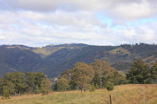 Due to this, we can now enjoy the Southern Highlands’ extensive green meadows and the spectacular valleys and gorges that make it a perfect 4WD destination.
This was our first visit to this part of NSW and we were keen to experience the bush camping along the banks of the idyllic Wollondilly Valley we had heard so much about. Departing from Sydney, take the M5 to Mittagong.
Once at the traffic lights at Mittagong’s town centre, take the right lane towards Berrima and Wombeyan Caves (Hume Highway), then continue out of town up a small hill before turning right onto Old Hume Highway towards Berrima and Wombeyan Caves.
 Look for the Wombeyan Caves signpost 5km out of Mittagong and take the right-hand turn onto Wombeyan Caves Road. Once on Wombeyan Caves Road, the route starts to change dramatically. After 25km or so the road changes to gravel as you head towards the Nattai National Park, which also offers some interesting 4WD tracks.
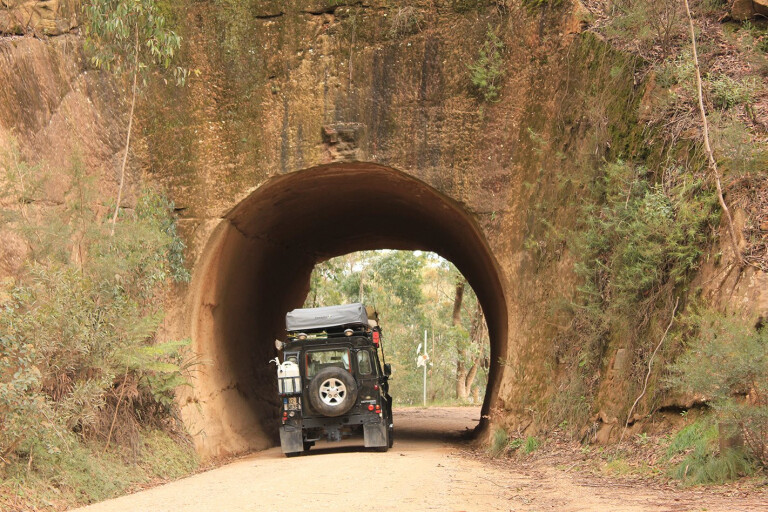
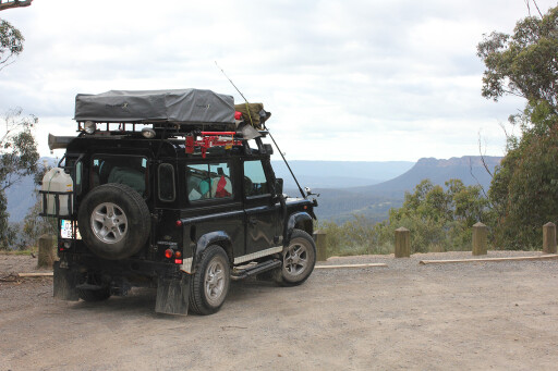
The first historic point of interest encountered on this trip is the Bullio Tunnel, which was unbelievably hand-carved in 1899. When you exit the other end of the tunnel, the unsealed road leads to a descending track that hugs the valley walls, providing spectacular views as you enter the heart of the Highlands.
Drive with care along this narrow and windy dirt track – if you suffer from acrophobia, the best advice is to not pay too much attention to the sheer drop into the thick scrub below. It’s a bit like driving on sections of Bridle Track near Hill End; although the surface of this track is in much better condition.
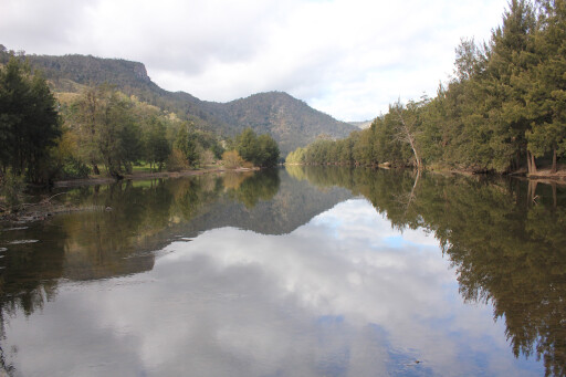
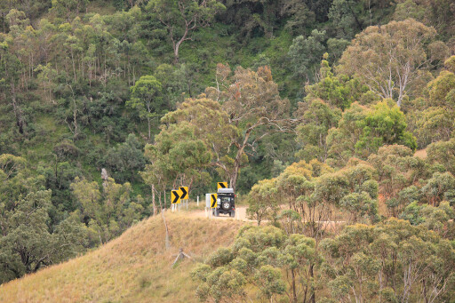 You will also encounter numerous blind corners and barriers, highlighting the need to drive slowly. As you wind your way down to sea level, you’ll reach the heart of the Wollondilly Valley (and your campsite for the night) when you cross the bridge at Goodmans Ford.
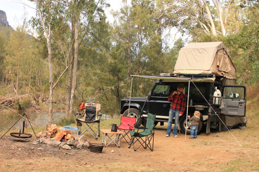
Jump out of your 4WD to take in this picturesque view of the valley and the majestic Wollondilly River; this view, with the high valley walls, provides the perfect photo opportunity. Signs to the Wollondilly Station are nearby, and this riverside campsite is a hidden treasure. Don’t expect any mod cons, but it is pet-friendly.
Most of the riverside pitches are private and spacious, with flat, grassy areas alongside the beautiful Wollondilly River. The river offers easy access for swimming, canoeing or throwing in a line from your camp chair to try and catch some dinner.
 The campground and its individual campsites have both two-wheel drive and four-wheel-drive-only access, and we chose to seek out the 4WD tracks that lead to some of the best camping spots along the river.
If you arrive at the campground and the owners are not in the office, you can contact them via a handheld radio that’s always left on the office table with the channel of choice clearly displayed. After setting up camp and getting the fire going, we decided to get out the camp oven, knead some dough, and bake some fresh bread in the open fire.
If you haven’t brought any firewood, you can purchase it at the main office.
 The following morning we continued along Wombeyan Road to the Wombeyan Caves. If reaching the caves from the campsite, you’ll drive up steep terrain and wind your way along the track before crossing a high saddle into Wombeyan Creek and then down again into the valley of Wombeyan Caves.
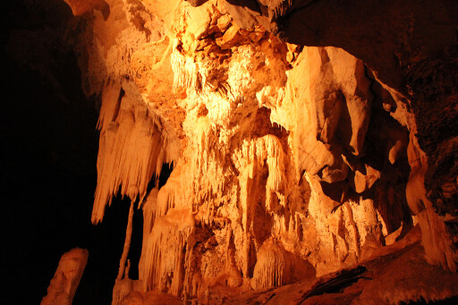
Wombeyan is an Aboriginal name which basically means ‘grassy valley between mountains’, and it’s widely agreed the caves provided shelter for Aboriginals when they seasonally travelled through this area in search of food.
MOREdestinations
The Southern Highlands caters for all types of tracks suitable for both beginners and seasoned campaigners. The Wollondilly Valley in the Southern Highlands is one such place, where you can relax at a tranquil bush camp for a couple of days, or you can use the valley as a base to do numerous activities including serious off-roading.
 The real attraction of Wollondilly Valley is the bush camping, the fishing on the river, and being allowed to light an open fire after a hard day of four-wheel driving.
If you’re looking for a mini adventure close to Sydney, Wollondilly Valley in the Southern Highlands will leave a lasting impression.
SOUTHERN LIFE
The Southern Highlands is a very popular destination for a number of reasons: the unsealed track that winds its way down into the Wollondilly Valley; picturesque waterfalls, valleys and gorges; the Wombeyan Caves; and some decent 4WD tracks, particularly in the neighbouring Nattai National Park.
SOMETHING FISHY
We took out the rods and did a bit fishing in an attempt to lure trout, carp or bass (fishing is possible all year ’round). If unlucky, you might snag a few unpalatable catfish. It doesn’t matter if you don’t catch any fish out here, as throwing a line along this peaceful river is as relaxing as it gets.
CAVE MEN
The impressive Wombeyan Caves were discovered in 1828 by a group of explorers led by John Oxley and John Macarthur. Oxley, who died later that year at a youthful 42, was responsible for much of the early exploration of the Southern Highlands.
Macarthur is known to many as the founding father of the Australian wool industry. In 1865, Wombeyan became the first area in Australia to be reserved for the protection of caves.
TRAVEL PLANNER
CAMPSITE
Campsite of choice was on the river at Wollondilly Station, with the property adjoining the river on both sides. The campsites are generous in size, and some of the best and most isolated sites are only accessible by 4WD. Campfires are allowed.
TRACK CONDITIONS
All tracks into the Southern Highlands and Wollondilly Valley are well-graded, unsealed roads. Wombeyan Road is a decent dirt track, but be wary as it’s narrow in places with steep drops. The scenic track takes you across the beautiful Wollondilly River Valley, from Mittagong to the Wombeyan Caves.
LOCATION
The Southern Highlands are 110km south-west of Sydney. To get to Wollondilly Valley from Sydney, head for Mittagong then continue on the old highway. Approximately 4.5km from town, take the right turn into Wombeyan Caves Rd, and you’ll know you’re on the right track after passing under the sandstone tunnel. The camping spot is located at Goodmans Ford.
MAPS AND GUIDES
Pick up some local tourist maps at the Mittagong Information Office, including the Southern Highlands map and directions (Phone: 1300 657 559).
New South Wales State map Series: UBD Map 270, 24th Edition, Scale 1:1 600 000.
CONTACTS
Southern Highlands Tourist Information: www.southern-highlands.com.au
Wollondilly Campsite: www.wollondillyriverstation.com
PHONE: (02) 4888 9207
Please enable JavaScript to view the comments powered by Disqus.
COMMENTS