Explore QLD
Gallery5
At the core of every four-wheel driver is an adventurer. These days, a true adventure is hard to find.
This feature was originally published in 4x4 Australia’s June 2011 issue
This was not so in the 1950s, when Percy Trezise, an Ansett pilot, would fly over the rugged terrain of southern Cape York and, with a bird’s-eye view, would record likely rock art sites on his charts.
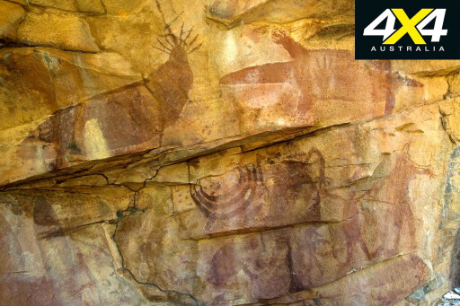 Later, with his friend and collaborator Dick Roughsey, Percy would hike into those areas, finding numerous sites rich in Quinkan rock art. By gaining the trust of the local elders, Percy and Dick learned about the mysterious figures and their stories.
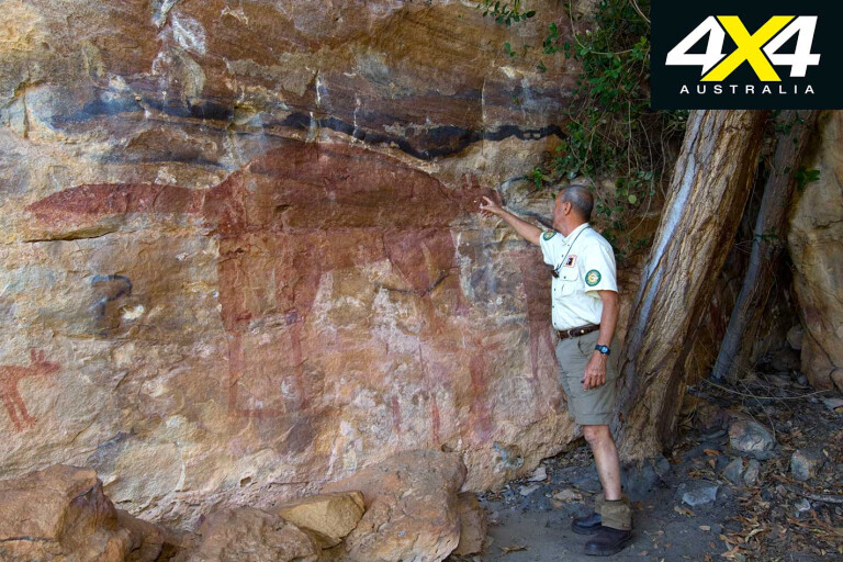
In the 1970s, Percy purchased a block of land where he could return again and again to favoured sites such as Emu Dreaming and Giant Wallaroo. His son, Steve, grew up with the Quinkan rock art, understanding it in the same way the rest of us might know a beloved illustrated book.
So, what does any of this have to do with four-wheel driving? Well, today Steve Trezise manages that same property, Jowalbinna, and, lucky for us, he offers outstanding bush camping near a crocodile-safe stream as well as rock art tours, with a fascinating depth of knowledge.
The perfect introduction to Quinkan Country is at the Quinkan and Regional Cultural Centre, in Laura, where you can learn about the Kuku Yalanji people and their lives with the Quinkan spirits stretching back 30,000 years. This rock art is of such significance that it was rated by UNESCO as one of the ten most important areas in the world.
5
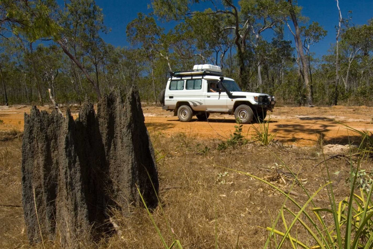
More salient, though, is the fact that to get to the Jowalbinna campground, you have to travel along a 40km track that deteriorates with every kilometre, and then to get to the sites you have to dip and bend at alarming degrees and angles on a tagalong rock art tour with Steve Trezise.
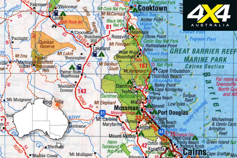
From Laura, turn south 3km past the roadhouse, following the signs to Jowalbinna via Olive Vale Station. Stop to engage low-range for the soft, sandy sections of the track and for the steep entry and exit creek crossings. Watch for wandering stock.
5
At 5km from the turn-off, follow the track right, indicated by a small Jowalbinna sign; watch for further signs along the main track. At 10km is your first creek crossing (an easy one), followed by another at 15km with Little Laura River soon running to your right.
MOREExplore
The creek crossing at 24km has a steep entry with a rocky bed, and low-range will probably be required. The Jowalbinna airstrip comes up at 31km, and at 36km is the start of at least three steep creek crossings with the last one (39km just before accessing the Jowalbinna Camp) definitely requiring low-range.
5
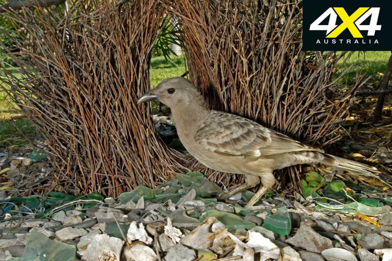
And there you are at the campground. The waterhole at the creek has safe swimming, complete with blue-winged kookaburras peering down from tree branches. Agile wallabies are easily spotted, but shy when approached too closely. Great bowerbirds construct their bowers under bushes. And then there are the rock art tours.
Drive out to the sites with Steve, or tagalong in your own 4X4, for a notched-up version of the track you drove down on. The rock art is superb, and with the unique chance to see it under Steve’s expertise, you’ll find that, to your surprise, art and four-wheel driving do indeed have something in common: Jowalbinna.
Travel Planner
5
WHEN TO GO
Mid-May through September.
DISTANCE
43km from Laura on the Peninsula Developmental Road.
COORDINATES
Jowalbinna turn-off: S15°33’04” E144°26’01”.
Jowalbinna Camp: S15°46’20” E144°14’48”.
NEAREST SUPPLIES INCLUDING FUEL
Cooktown. Lakeland and Laura have fuel and limited supplies.
WHAT TO BRING
Everything, including drinking water
and emergency supplies, recovery gear,
two spares. Ring in advance to book campsites and rock art tours
TRACK DIFFICULTY AND VEHICLE REQUIREMENTS
4X4-only track with deep potholes, sand, steep creek crossings, corrugations and wandering stock. Low-range and high clearance required. Tents or off-road camper trailers only.
CAMPING & ACCOMMODATION
Tent and camper trailer camping with toilets and showers, but no power or water. Accommodation and meals available if booked in advance.
CONTACTS
Stephen Trezise, phone 07 4060 3236 (guided rock art tours from $45 to $75).
See jowalbinna.com.au.
Quinkan and Regional Cultural Centre, Laura, quinkancc.com.au or phone 07 4060 3457.
RACQ (road conditions), racq.com.au or phone 1300 130 595.
MAPS
Hema’s Cape York Atlas and Guide.
FOUR-WHEEL DRIVING
Opportunities on return journey for fully-equipped, experienced drivers only:
South of Jowalbinna is the extreme Maytown Track. Count on an eight-hour crawl to Maytown (55km) in low-range the entire way, with another three hours to connect with the Peninsula Developmental Road (79km). Emergency plans, supplies and communications are musts.
Laura to Cooktown via Old Laura and Battle Camp Road, very rough 138km track.
Please enable JavaScript to view the comments powered by Disqus.
COMMENTS