Explore WA
Gallery38
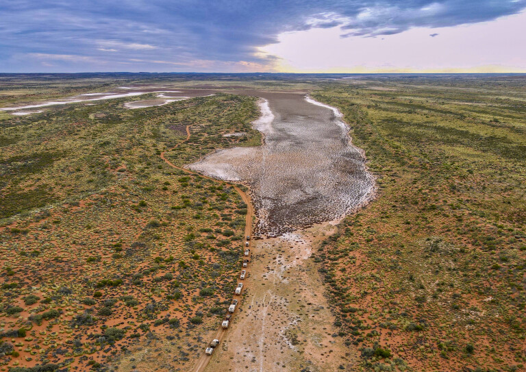
The change was dramatic! Less than 12 months previously, the lake was full to the brim with life-giving water. Now, while its surface glittered like the mirror of an inland sea, it was all but a mirage; only in the centre of the once expansive lake was there a hint of moisture, but even that was nothing more than a thin veneer of water over mud that was fast becoming desiccated, cracked and dry.
I was disappointed, having thought that once full and with rain in the intervening months since my last visit, there would be enough water to revel in this inland oasis. But, like most surface-water sources in the vastness of the Gibson Desert, they are ephemeral expanses subject to wind and unrelenting sun; their existence measured in days and weeks, not months or years.
38
On a large coolabah on the edge of the drying pan, a group of 10 or so white-faced herons perched forlornly and dispirited, their fate sealed by the vanishing waters and their retreat back to more permanent reservoirs cut off by the expansive sea of sand now devoid of any life-giving succour and any hope of escape. They were doomed, and they seemed to know it.
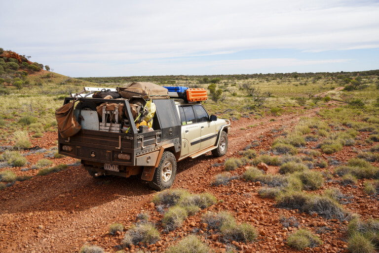
Our fate wasn’t anywhere near as assured, permanent or as dramatic, and we decided to camp on the flat dry pan well away from the spinifex and scrub that dominated the surrounds. And while there was little or no water, Lake Cohen, just off the north-south track that is the Gary Highway, makes for a pleasant camp; it’s just better when it is full of water.
Coast to coast
Our small group of adventurers, part of Moon Tours’ legendary Coast to Coast Expedition, had begun their adventure in Ceduna on the far west coast of South Australia.
After wandering north, taking in little known goldfields near Kingoonya and experiencing a delightful and interesting stay at Mt Eba, a sheep property in the centre of SA, we turned west along the Anne Beadell Highway. This route, with its many challenges and adventures, not to mention atomic bomb sites, had us enthralled for five days, before we joined the easy going of the Great Central Road to the Aboriginal-owned Tjukayirla Roadhouse.
38
Leaving the relative confines of civilisation that Tjukayirla offers, each and every vehicle was full to the brim with fuel in readiness for the long haul of more than 1000km to the next drink of diesel. We backtracked a short distance and swung on to the David Carnegie Road, the route north being well-defined and easy, well, at least for a time. That night’s camp was in an area recently burnt and devoid of the cursed spinifex that covers vast swathes of country here.
Next morning for a few hours we explored the area around Breaden Bluff, the area named by David Carnegie during his 1896-97 expedition that crossed Western Australia from Coolgardie to Halls Creek and back again. The low escarpment that makes up the bluff is riddled with caves and overhangs, many showing signs of where animals had sheltered – and some even indicating past human habitation.
Empress Spring
Some 20km or so farther north, we suddenly came to a small clearing, the Hema Navigator on my dash indicating we were close to David Carnegie’s famed Empress Spring. Led to this water source by a friendly Aboriginal, he named it in honour of Queen Victoria.
Today, it is much the same as when Carnegie discovered it – save for a small bronze plaque on a nearby boulder indicating that a modern-day politician had been here in 1996 and named the route we had been traversing, leading to this lonely spot, the ‘David Carnegie Road’.
38
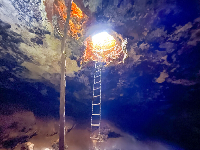
In a depression amongst the surrounding natural limestone sheeting that occasionally showed itself through the red sand, a small hole drops into a large cavern, the access made easier by a chain ladder supported, somewhat dubiously, by a steel bar resting on a small pile of limestone rocks.
Seven metres down, the floor of the cavern slopes away into an ever-narrowing tunnel which leads to a small pool of permanent water, some 16 metres from the entrance hole.
While wandering bands of Aboriginals have long depended on this source of water, so too do hundreds of zebra finches which fluttered around us, disturbed by our presence but unwilling to fly very far away from the only source of water for many kilometres. They are gutsy little birds, having to fly into the darkness to reach the life-giving fluid, something they have to do each and every day.
Go Aussie
North of the spring, the route deteriorates, being a two-track and eroded in places with the scrub closing in from both sides, while the route twitches this way and that amongst the trees and branches. Along this section, we passed an abandoned camper, adding to the toll we had seen along the Anne Beadell.
The lesson was simple enough, if you want to take a camper or trailer of any sort through this seemingly boundless desert country, make it a good one, preferably a well-known Australian-made off-road unit.
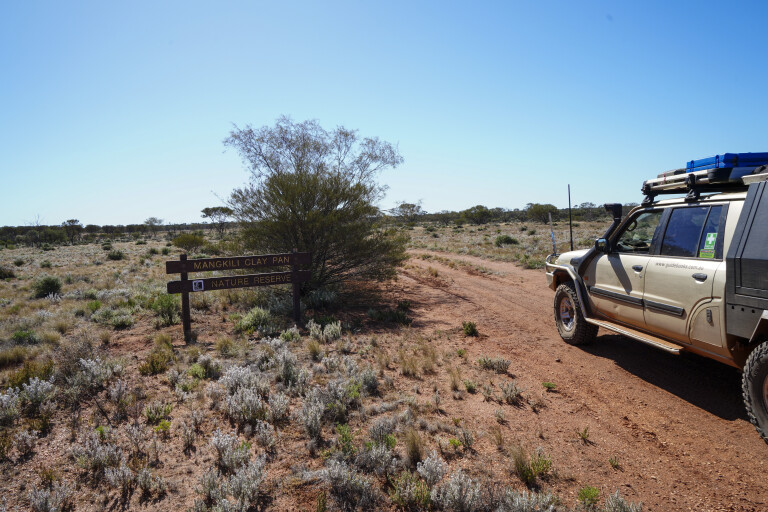
Meeting with the Gunbarrel Highway at Mangkili Claypan, we turned east along this famous outback road which became a track as it cut across a vast sea of seeding spinifex. Established by Len Beadell and his Gunbarrel Road Construction Party in the 1950s, the then-graded route was the first across the desert to link the Stuart Highway south of Alice Springs to Wiluna in the goldfields of WA.
38
That evening we pulled into the small clearing surrounding the Geraldton Bore, its life-giving waters an attraction for us and for the dozens of finches that call the bushes and trees here, home.
We had stopped early as one of the camper trailers had a singing wheel bearing, and as clothes were washed, dinner cooked and beers drank, we changed both the inner and outer bearings. This is a relatively easy operation if you have the knowledge and the spare parts to do that. It’s a lesson in self-sufficiency that everyone who comes out here should be aware of.
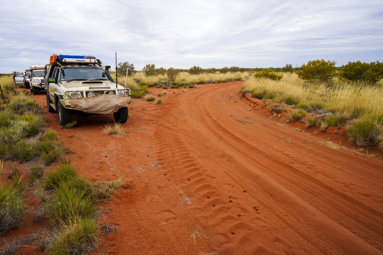
Turning north at Everard Junction, we met up with our drying Lake Cohen and after a night there we pushed on to Windy Corner, turning westward again, but this time pushing through scrub that had overgrown the two faint wheel marks known as the Talawana Track, another of Len Beadell’s roads.
The going was slow, especially after a couple of the rigs suffered a puncture, making it just four for the whole trip amongst our group. While substantial enough, it was a small price compared to the previous trip 12 months earlier when we had suffered a lot more punctures and damage. That trip also saw us forced to turn around about 10km west of Windy Corner, when we came across a lake cutting the Talawana Track.
38
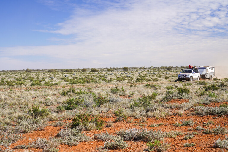
This year the route was free of water but all that moisture meant that the scrub growth was thick and at times we were forced to cut trees and branches out of the way and just push our way through.
The spinifex was tall and thick, sprouting from the centre strip of the track; the danger of not checking beneath the vehicles at regular intervals was reinforced by the five vehicles we came across burnt out from the highly combustible spinifex catching alight.
The relief amongst the convoy was palpable coming to Midway Well, with the now recently graded Talawana Track continuing westward. With mineral exploration going on unchecked and increasing in size and scope, many of the existing tracks have been regraded and new ones established. Our speed increased to an unheard of 30 to 40km/h and we met with the Canning Stock Route, just north of Well 24, in what had seemed an unattainable goal a few hours previously.
That evening, we pulled up below some red bluffs north of Well 23, the clearing at the well once a major fuel dump now overgrown and little used. Continuing on along our mining access road next day, we refuelled at the friendly Parnngurr Aboriginal Community, and yarned to the headmaster of the local school and the store manager who opened specifically for us – they were the first people, outside our group, we had seen since leaving Tjukayirla a week previously.
Our vehicles drank heavily from the underground tanks before every one of us raided the well-equipped general store for everything from meat and vegies, to milk and ice creams.
Karlamilyi National Park
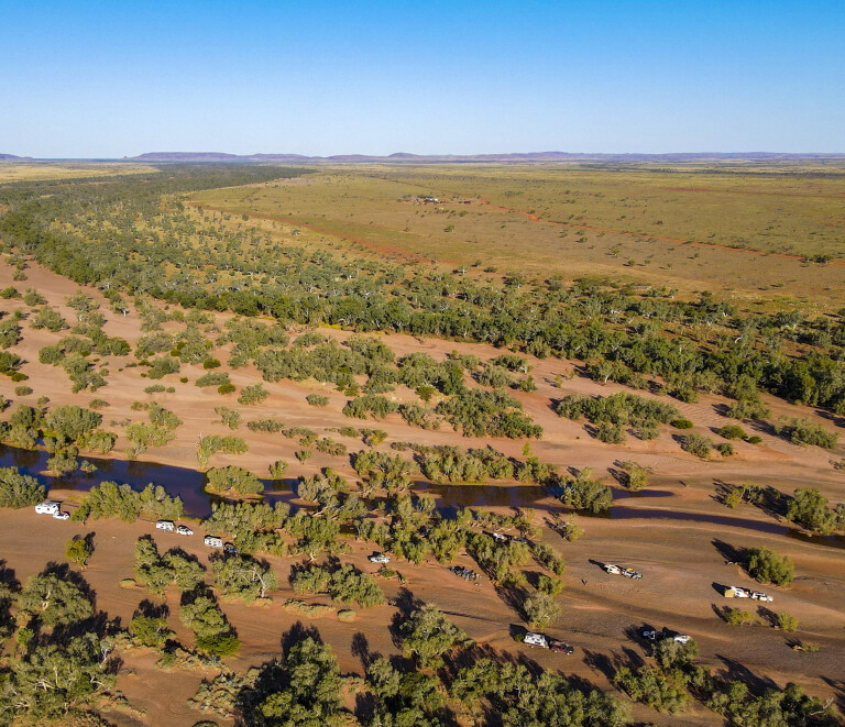
Refreshed and refurbished, we headed on and turned north into the Karlamilyi (Rudall River) National Park, camping on its southern boundary amongst a delightful stand of white gums. Sadly, the bore and hand pump that was once here and was a great source of delightful water is no longer available, which is a great shame.
Wandering northwards into the heart of the park – the largest in the state and one of the most remote – we camped at different places along the way, having the areas to ourselves and enjoying the refreshing waters of Kalkan Kalkan Soak and Tjingkulatjatjarra Pool, amongst others.
38
With the area dotted with a variety of habitats along with pools of permanent water, the bird life through here and the amazing variety of flowering plants were a delight to the senses and in stark contrast to the seemingly endless sand plains and spinifex we had travelled through.
Imagine our surprise (and disappointment) though, when we visited the famed Desert Queens Baths to find three separate groups of a couple of cars each camped there. After the solitude we had experienced since joining the Anne Beadell Highway nearly three weeks previously, it was a rude awaking of the impending meeting with civilisation that was edging ever closer. Still, we made the most of it, as you do.
After passing the huge workings and mullock heaps of the Telfer Goldmine we turned westward once more, meeting the bitumen before stopping overnight at the Meentheena Veterans Retreat. The camp here is situated close to the waters of the Nullagine River and it was where all of us enjoyed a hot shower (the first in weeks), before sitting around a great campfire yarning and drinking a coldie or two.
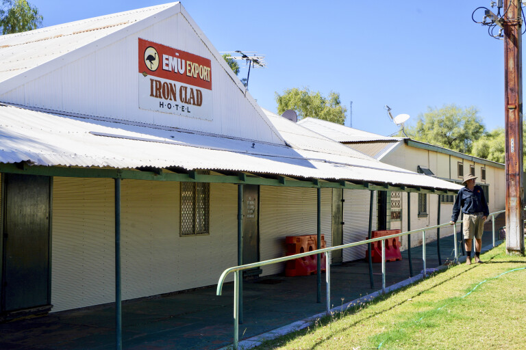
Iron Clad Hotel
Marble Bar with its famous Iron Clad Hotel was the next stop, and that evening was spent on the wide sandy bed of the De Grey River, our last bush camp before we followed a not-so-old but still disused railway line west, from what was the Shay Gap mines, to the Great Northern Highway.
38
That evening our camp at Pardoo Station was just a stone’s throw from the Indian Ocean – our Coast to Coast expedition was complete, and while we counted the cost in tyres, bent rims (only steel rims were bent, surprisingly), a few broken brackets, some crook wheel bearings that needed replacement along with patched-up shock absorber mounts, we thought we had come through remarkably unscathed.
For that, we celebrated in fine style with a group cook-off and a host of drinks and surprises before we headed off on our own separate adventures; but that is another story for another day.
Top 5
01: Emu A-bomb sites
Along the Anne Beadell Highway in SA you’ll come across Emu Field, a flat sandstone plateau in the Great Victoria Desert, where in 1953 the UK conducted two nuclear tests known as Operation Totem. The site was surveyed by Len Beadell in 1952, with a village and airstrip subsequently constructed for the Totem testing program. Stone monuments at the ground-zero points can be visited by tourists (with approval of the RAAF Woomera Test Range, who control access to the area).
02: Len Beadell’s roads
The Gunbarrel Highway is the best known of Len Beadell and his work crew’s road-building exploits last century, which opened up large chunks of isolated desert regions in SA, WA and the NT. In all, Len and crew created 6000km of new roads from the late 1940s to the early ’60s. Known for his humour, Beadell named his unsealed roads and tracks as ‘highways’ and had a penchant for naming several of them after family members: Anne Beadall Highway (wife), Connie Sue Highway (daughter), Gary Highway (son) and Jackie Junction (daughter) to name a few.
03: Desert Queen Baths
Desert Queens Baths are a series of permanent, spring-fed freshwater gorge rock pools, which are part of Denny Creek, a tributary of the Rudall River, located within Karlamilyi (Rudall River) National Park, some 500km south of Broome. Karlamilyi is said to be the only national park in Australia that encompasses an entire seasonal river system in the arid zone, and lies at the junction of the Great Sandy and Little Sandy Deserts.
04: Empress Spring
Empress Spring, also in the Great Victoria Desert, is a unique waterhole as it’s a large underground cavern that is now accessed by a chain ladder. Explorer David Carnegie named the waterhole after Queen Victoria in 1896, after being guided to the spring by a local aboriginal following many days without finding water. You can get to Empress Spring via the Gunbarrel Highway to the north or the Great Central Road to the south.
05: Indian Ocean
Nothing better after a long desert crossing than a paddle in the warm waters of the Indian Ocean on the far NW coast of WA.
Travel Planner
You need to be well-prepared and experienced to travel this remote country. Best to travel in a group. If you are not experienced, consider travelling with a tag-along group or a 4WD club. Moon Tours (see: www.moontours.com.au) specialise in taking camper trailers and camper vans (only Aussie-made ones need apply) into remote areas of Australia. They run a Coast to Coast Expedition each year.
For info on permits required to travel these remote desert tracks, click here.
Fuel and limited stores are available at:
- Ilkurlka Roadhouse – Ph: (08) 9037 1147
- Tjukayirla Roadhouse – Ph: (08) 9037 1108
- Parnngurr Aboriginal Community – Ph: (08) 9176 9051
Camping is also available at:
- Kingoonya – Ph: (0409) 401 715
- Mt Eba Station – Ph: (08) 8672 8930
- Meentheena Veterans Retreat – Ph: (0497) 004 491
- Pardoo Station – Ph: (08) 9176 4930
Further reading:
- Hema Maps, Great Desert Tracks Atlas & Guide is an invaluable resource for this huge region of Australia.
- For more on Len Beadell, the roads he made and the adventures he had, and to source his many books, see: www.lenbeadell.com.au
Please enable JavaScript to view the comments powered by Disqus.
COMMENTS