Explore NSW
Gallery5
The ruggedness and complexity of the Blue Mountains landscape thwarted many early attempts to cross it by expeditions launching out from the fledgling colony of Sydney.
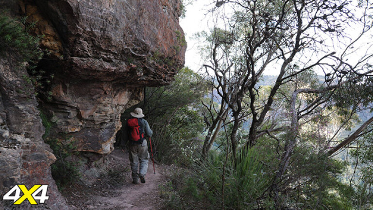
Those same steep sandstone cliff faces and deep wooded valleys provide present-day bushwalkers with a complex and immersive landscape in which to explore.
The Ruined Castle is a sandstone rock formation in the Blue Mountains National Park that commands 360 degree views of the Jamison and Cedar Creek valleys from its location on a low ridge below the continuous Narrow Neck cliff line near Katoomba. The steep-sided tors that constitute this feature appear from a distance like the crumbling battlements of a stone castle, hence the name. The walk down a steep pass called the Golden Stairs to the Ruined Castle is a great introduction to the region. It has relatively straightforward access along an ageing walking track that was once a horse-drawn tramway used to remove shale for oil extraction from a mine below the Ruined Castle itself.
The route along the side of the Jamison Valley levels out after the steep descent down the Golden Stairs, and considering the rugged nature of the terrain, is a relatively moderate excursion. It is about eight kilometres walk from the Golden Stairs car park to the Ruined Castle and back, with steep ascents and descents at either end. The climb up to the Ruined Castle is a little loose and eroded at first, requiring care, until the track levels out before the summit rocks. The views from the highest point are extensive in all directions, and provide some small flat areas for a lunch stop.
A worthwhile extension to this walk for those with the time and experience is to continue past the Ruined Castle to Mount Solitary. An indistinct but continuous walking track continues south and climbs very steeply up the Korrowall Knife-edge ridge of Mount Solitary itself. This isolated remnant of the eroded sandstone plateau sits in a commanding position south of Katoomba, dominating the view across the Jamison Valley. It’s a unique destination, being an ‘island in the sky’ that conceals an untouched landscape of perched swamps, hidden waterfalls and large sandstone cave overhangs, suitable for camping in. On its southern side there are extensive views over Lake Burragorang (the storage lake for Warragamba Dam) and the wild gorge of the Kowmung River and beyond. Mount Solitary involves steep, hard climbs and descents, and its few creeks can be bone dry in drought conditions, making a check with the NSW National Parks & Wildlife Service a necessity before an ascent.
The Blue Mountains National Park is a vast and complex series of plateaus, cliffs and steep gorges. A walk out to the Ruined Castle gives a taste of what the remoter sections of the park have to offer, with fantastic views along the way, but relatively easy access. It represents a comfortable corridor into a formidable and rugged sandstone landscape.
WHEN TO GO
Autumn, spring and early summer visits provide the mildest weather, however it can be windy. Winter provides crisp, cold days, however snow and rain are a distinct possibility in July and August. Late summer can be hot and humid with significant bushfire risk.
GETTING THERE
Take the Great Western Highway from Sydney to Katoomba. Follow signs to Cliff Drive and continue past Scenic World to the unsealed Glenraphael Drive on the Narrow Neck Plateau. Follow to the Golden Stairs trackhead (signposted) and car park.
USEFUL BOOK
Day Walks Sydney, John and Monica Chapman (1st Ed. 2011)
USEFUL MAPS
Katoomba 8930-II-N and Jamison 8930-I-S, 1:25,000 Topographic Sheets, NSW Dept. of Lands (3rd Ed.)
Please enable JavaScript to view the comments powered by Disqus.
COMMENTS