Explore NT
Gallery13
ARNHEM LAND is a region I lived in for 10 years, during the entirety of the 1980s. But my first experience goes back to 1963 when a mate and I drove from Pine Creek to what is now Kakadu National Park. At Yellow Waters we caught barramundi and shot buffalo and boar; it was a Boy’s Own adventure.
Other trips followed, but in 1977 I flew into Maningrida for a three-week fishing trip as guest of a mate. The locals took me out fishing and crabbing in the Liverpool and Cadell Rivers, and it cemented a reason to return. I did so when I landed a job as information officer with the new Ranger Uranium Mine at Jabiru in 1979. Living there was a dream for a fisher and hunter and most weekends were spent chasing that dream, but I left Jabiru in 1989.
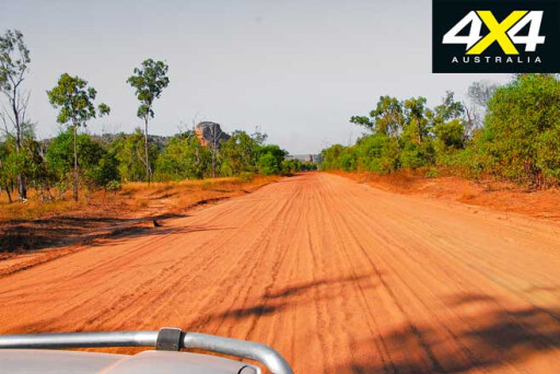
I renewed my friendship with the indigenous people of Maningrida as much as I could, taking several trips up there. The Central Arnhem Land Road was only a 4WD track in those days and it took almost a day to travel the 300km. These days the road has been upgraded to a good gravel surface, but the river crossings remain and only 4WDs can travel on it.
I was instrumental in arranging meetings between the traditional owners and Kenny Russell, who started the Arnhem Land Barramundi Nature Lodge. I flew in from my Queensland home to fish and promote the lodge many times and still do. The fishing is out of this world and is the reason why the area is high on the bucket list of anglers.
When Russell pulled out of the lodge, fishing media personality Alex Julius and legendary fishing guide Lindsay Mutimer took over, expanding the operation. Lindsay dropped out later and Alex operated it for years before it was sold to Outback Spirits.
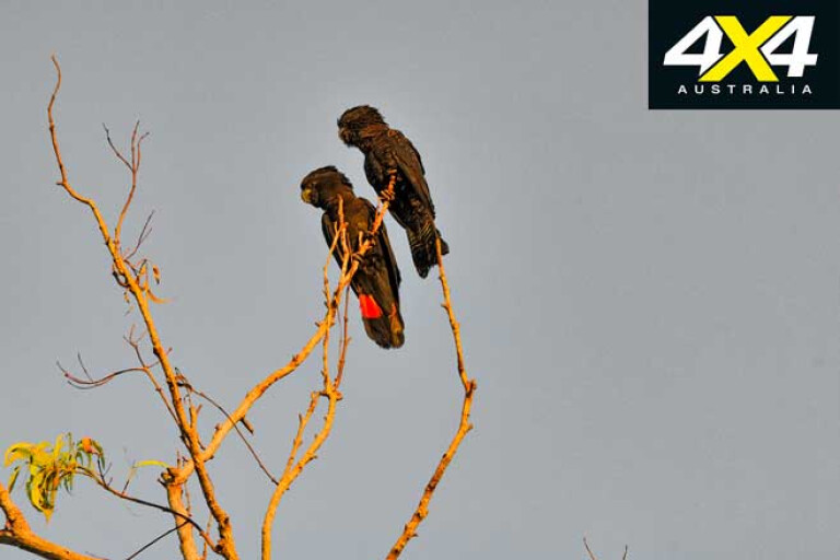
Alex is a mate, and I made many trips by road and air to Maningrida to fish the lodge and promote it in my articles. As a bird lover, I noted many species that call the region home and mentioned to Alex that a birdwatching operation would be popular.
The outcome was that Lindsay, Trevor Robb and I did a bird count and in four days we ended up with a massive number of 194 species within a 50km radius of the lodge (which is 20km south of Maningrida).
13
We organised a bird week, with myself as a guide. I was joined by an old mate from my Jabiru days, Johnny Estberg, and one of the NT’s most noted bird experts, Professor Richard Noske. We did two bird weeks a year for several years, plus I did many purpose-guided tours for individuals and small groups.
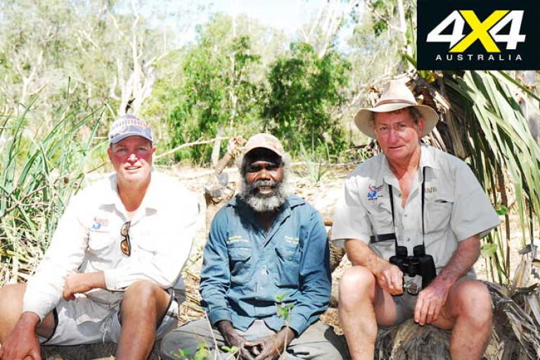
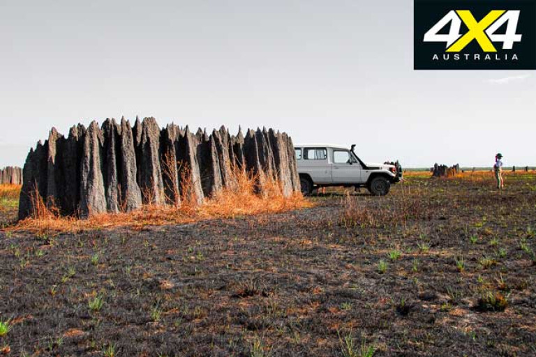
We had to take an Aboriginal guide with us to ensure we didn’t wander into forbidden areas. One was Stuart Aiken, who one day told me I was to be his brother, a great honour that meant I was to be accepted in his clan. I met his family members and others and was trusted to roam on their land alone with clients. Their land borders between the Cadell and Blyth Rivers, an area consisting of open flood plains, vast swamps, patches of monsoon rainforest, open woodlands and mangroves forests.
A network of tracks provides plenty of access, but if there are none the locals make their own with Land Cruisers and Troopies. I have seen them fearlessly driving into kilometre-wide swamps, following old walking paths. If a 4WD gets stuck, they may leave it there until the swamp dries out enough later in the dry season.
13
Picture: (from left) Trevor Robb, Stuart Aiken and Dick Eussen
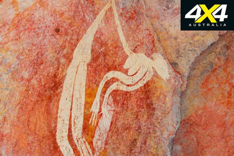
In search of rare birds, we travelled on bush tracks right to the base of the imposing Arnhem Land Escarpment. In the many outliers that jut out from the main range we discovered cave paintings that had never been seen by anyone, apart from local Aborigines.
One showed a woman being hit by lighting. I told the Indigenous guides that this had also happened to me, and I was an instant legend to have survived that – it’s true, and the reason I have a pacemaker fitted.
We were taken to burial sites, hidden springs and other rare treasures. The guides had never been there, but they had been told by the elders where they could take us and how to find such places, a rare happening indeed. The birding was outstanding and so was the game, with big boars and even bigger water buffalo adding an element of danger to the outings.
Arnhem land
13
THE region was named by Dutch sea explorer Willem Joosten van Colster who sailed into the Gulf on the ship Arnhem in 1623. Later explorers, like Mathew Flinders, reported other boats in the surrounding seas including prau sailboats manned by Macassans who hailed from Sulawesi to harvest trepang, a harvest that started in 1705.
The trepangers had a major influence on the Aborigines, with some coastal tribes working for the fishermen. However, other tribes were not so welcoming and would attack and kill the trepangers if they landed on their shores.
Many Macassan words were learned and there were marriages, with some locals travelling home with the trepangers and returning the next season when the northwest monsoon winds were favourable. One Macassan word that is widely used is balanda, meaning white man.
When the Top End was settled in the early 1800s by the British, they had hopes of setting up a trading post with the trepangers but it never got off the ground. Later, when Darwin – or Palmerstone, as it was first called – was established, Europeans chased trepang, and as the Chinese outnumbered the whites 10 to one in the Top End in those days, there was a strong market demand for the sea slugs. Some whites would chase native girls, and this sometimes led to open warfare.
13
A custom officer, Alfred Searcy, was appointed to collect tribune from the trepangers in the 1880s. They were also discouraged, which led to the Japanese fishing the coast. The natives hated them with a passion and five Japanese were killed in Caledon Bay in 1932. The police sent in a patrol to arrest the culprits but withdrew when one of their own was speared on Woodah Island.
When word reached Darwin, there was uproar. A rum-fueled mob set out down the track but returned when they sobered up. Calls came from the deep south and orders for restraint, and the Church Missionary Society volunteered to bring the murderers to Darwin.
No one is sure how they convinced them, but the missionary lugger Holly landed in Darwin with the alleged culprits onboard. A lynch party formed, but were held back by the police.
The court case was a farce as none of the natives spoke English. The leader Tuckiar was found guilty and sentenced to death, while three of his men were given 20 years of hard labour. It created a storm of protest from the deep south and a High Court appeal was launched. Tuckiar was freed. He was taken to the Aboriginal Reserve in Darwin to await transportation back to his homeland, but he vanished and was never seen again. Due to the work and appeals from the missionaries, the other killers were set free in 1936 and returned home.
13
Even earlier, other happenings in the region led to the declaration of the 97,000km² Arnhem Land Aboriginal Reserve after two white trepangers were speared on Woodah Island. The reserve was off limits to whites and anyone going there did so at their own risk as no police protection could be counted on. Some persisted and paid for their folly.
Today, Arnhem Land is in transition. With a population of about 16,000, it remains sparsely settled with a handful of remote communities scattered about the region. Most are located on the Gulf of Carpentaria and Arafura Sea shores, as well as on offshore islands.
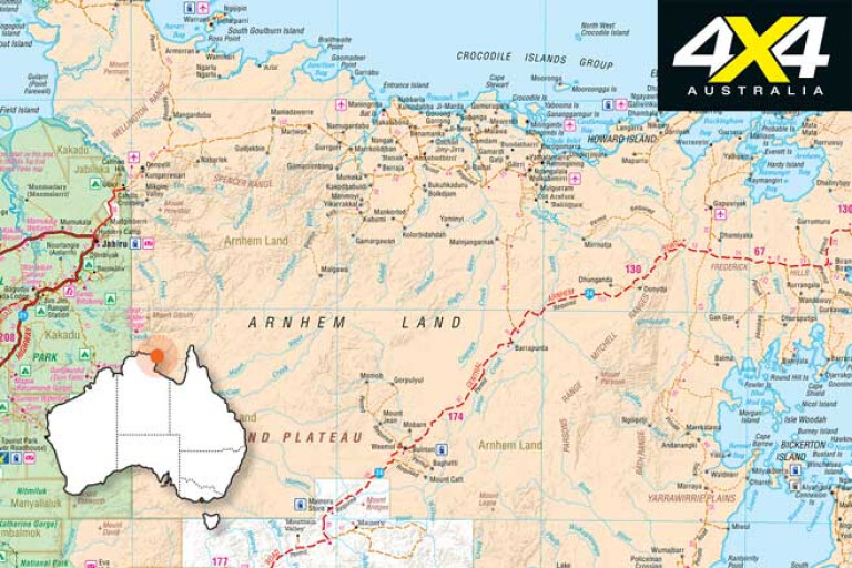
It’s difficult to enter Arnhem Land because it’s surrounded by seas on the west and the north, while to the south the NT’s largest perennial river, the Roper, marks the southern border. To the east, the 300m-high Arnhem Land Escarpment towers over the land. Only three roads enter this vast region, two from the south and the other from the east.
Adventures in Arnhem land
13
DUE TO my magazine duties and bird-guiding at the Arnhem Land Barramundi Nature Lodge, I have enjoyed many a stay there. I’ve mostly flown in, but there have been many times I have driven the 550km journey from Darwin.
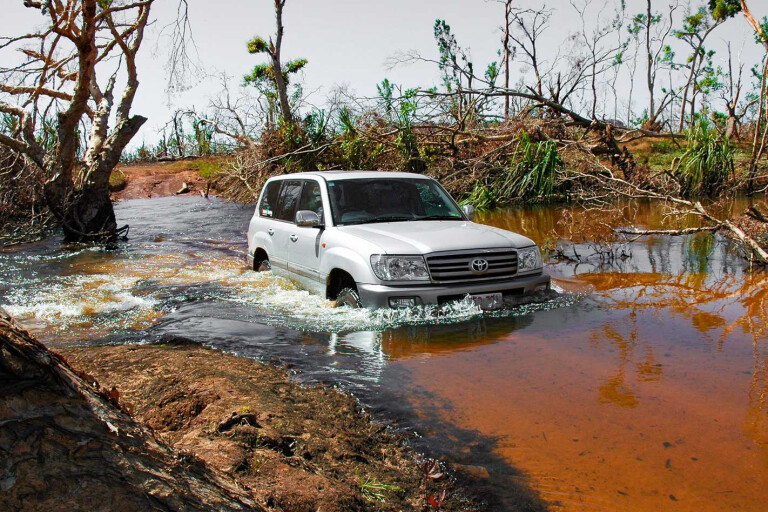
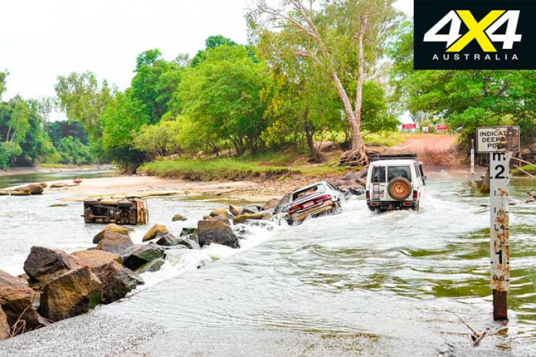
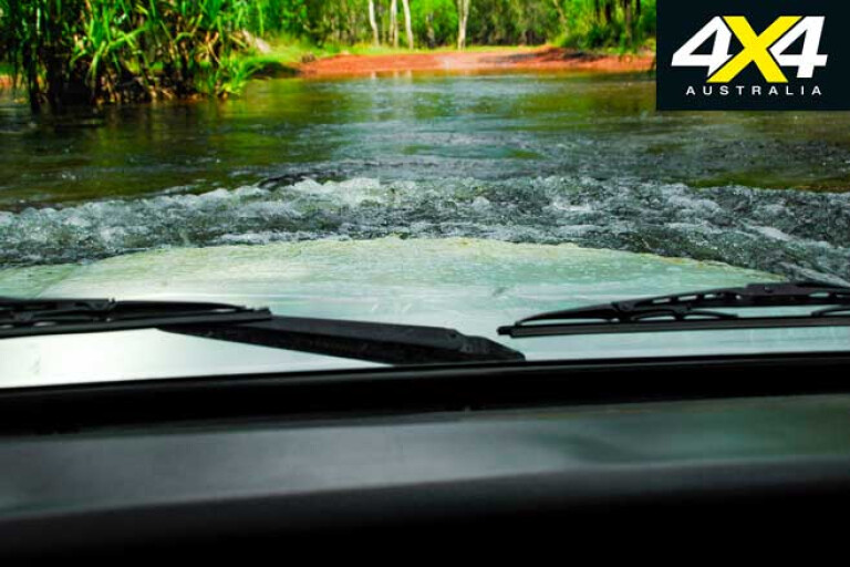
The East Alligator River marks the boundary of the Kakadu National Park and Arnhem Land. Cahill’s Crossing is tidal influenced and very treacherous just after the wet season or when a “fresh”, caused by an upstream storm, sweeps down the river without warning.
A few years ago, Alex Julius asked me if I could take a Toyota Land Cruiser and a 5m plate boat to the lodge. It was just after the Wet season and from experience I knew that the crossing and the Central Arnhem Land Road were still treacherous. He told me that a main road inspector was en route to the lodge and would report back on road conditions.
So, Ken Phillips, a retired NT police sergeant, and I set off to time low tide at Cahill’s Crossing to perfection. Even though the river was high, we had plenty of weight onboard the Cruiser and the boat to keep it on the causeway.
13
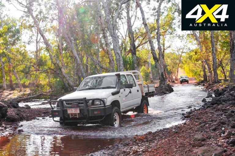
It’s a wonderland across the river – the place where the Crocodile Dundee II movie was largely filmed. There were plenty of wash-outs, but we took turns driving and took it easy. The King River was high but vehicle tracks on the other side indicated that someone had gone across it.
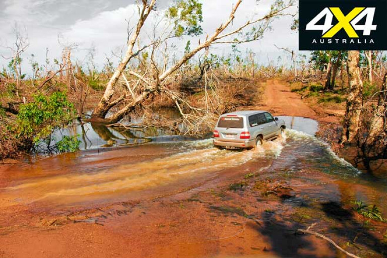
We made it okay, but the next river – the Gomadeer – has a sandy bottom. It was deep and flowing hard, but the powerful Cruiser plowed through it and the boat floated behind it. From here the road led through tall ancient monsoon woodlands before dropping down into paperbark tree country that was full to the brim with water that lapped the road or covered it in many sections.
For more than 20km we traversed the ti-tree swamps, the track marked by the wheel sets that had gone before us. Had we met anyone coming towards us someone would have had to do a lot of back-tracking. We reached rocky country where high, deep, running creeks dominated and slowed us down.
13
We also met the returning road inspector at a place where there was enough room to pass without dropping into the water-filled table drains. The inspector told us the rivers were running high and looked at the boat before wishing us luck.
We continued, directly into a huge “knock-em-down” storm. Another had formed behind us. These storms roam the Top End after the Wet and are called so because the powerful winds that create them blow everything that nature has no need for away. They also drop a lot of rain, up to 100mm in some instances; something we didn’t want.
We reached the Liverpool River, a 40m-wide deep stream. There was a lot of current in it, but with the windows open – ready for a rapid exit if needed – I drove into the current using the right bank. The water’s force pushed the Cruiser into the middle and I noted in the rear vision mirror that the heavy boat was floating and threatening to pull the Cruiser into the fringing pandanus that lined both sides of the crossing.
The rear wheels were starting to lift, before the front wheels gripped and I drove jubilantly onto the other side, the boat trailer pulling some pandanus leaves with it. It had been close; too close. Ahead lay the 100m-wide Mann River. Getting there was a feat, as most of the road was under water.
We breathed a sigh of relief when we saw the river, as it was down compared to the Liverpool. The Tomkinson River is shallow, but can be boggy. We made it and drove into the blackness of the big storm. Visibility was down to 40 metres, as lightning hit trees around us and the whipping wind blew leaves and branches into the windscreen. There were more ti-tree swamps and more flowing creeks and gullies, enforced by a “fresh” from the storm before we hit the high country and triumphantly drove into the lodge where Lindsay Muttiner handed us a beer for a job well done.
Deja Vu
13
SOME years later, I drove a Toyota Troopie loaded with 1.5-tonne of supplies, mostly beer, to the lodge. It was mid-October, but already big build-up season storms were roaming the Top End. Along with me for the ride was fishing guide, Grassy. The East Alligator River had escaped a “fresh” so far and Cahill’s Crossing was shallow.
The Goomadeer River was running high and over the tyres, but we made it okay. There was a semi-trailer parked on the other side and the driver told us the Liverpool was up to the level of his trailer, which was about level with the top of the Troopie’s windows. He told us there was no way we would make it, but we were committed and the least we could do was have a look.
The river was high, but it had surprisingly little current in it. I put the Troopie in low range 4WD and third gear and committed ourselves to the river, even though Grassy wanted us to turn around and go back because storms were forming all about us.
13
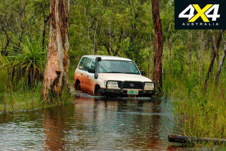
The stream was deep and flooded over the bonnet, with some water splashing into the vehicle on my side through the open window. There is no way I will wade a stream with windows closed and seat belts on, because if you need to evacuate there is no time to wind windows down and undo belts.
Also, of note, is that electric windows may not work once the whole system is flooded. Time and time again, I see TV presenters cross flooded or rushing streams with belts on and windows wound up.
We both breathed a sigh of relieve when the Troopie crawled out like a wet dog on the other side. There was about 50cm of water in the vehicle, but most drained away when we opened the doors.
13
Ahead lay the 100m-wide Mann River, but getting there wasn’t easy as a storm had turned the road to mud. The Mann was running higher than I had ever seen it, even the island in the middle was underwater.
With Grassy on the camera and me on the wheel, we committed ourselves to let the Troopie do its work, and it never hesitated in the crossing. As it had done almost a decade before, a storm broke over us when we were halfway across, but we jubilantly drove out of it.
We noted slewing tyre marks near the Tompkinson River crossing and soon caught up to a 100 Series Cruiser towing a large trailer. The driver was surprised when I passed him. It was Seb Lord of Lord of Kakadu Tours, who was en route to Maningrida to pick up clients at the airport and take them back to Kakadu. He told us that it was his worst trip ever, but I don’t think he believed me when I told him about my trip some years before…
13
I fished for a week in the region before catching an Airnorth flight back to Darwin. The Wet proper set in during that week, with huge ground-shaking thunder storms and jagged lighting. Such early monsoon flows happen at times, perhaps every decade or so.
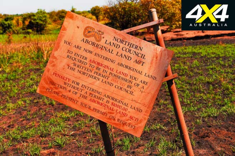
Arnhem Land is an exiting 4x4 adventure, but unless permits are issued by the Northern Land Council (www.nlc.com.au) the region is out of bounds for casual travelers, which is a shame as it has more to see than Cape York Peninsula.
Please enable JavaScript to view the comments powered by Disqus.
COMMENTS