Explore NT
Gallery2
TO exit your four-wheel drive and have the full force of the Northern Territory’s heat slap you in the face, as well as spinifex grass piercing your legs as you walk towards a geological wonder, is all part of the extraordinary journey to reach a destination that no aerial photo can quite do justice.
Located in the vast, open rocky country north-west of Borroloola, and guarded by the many tributaries of Batten Creek, lies the Nimbi Nimbi sinkhole.
 Borroloola, which is on the Narwinbi Aboriginal Land Trust, is a diverse community approximately seven hours’ drive from Katherine, and it’s also the starting point to access the sinkhole. A permit isn’t required to visit the town of Borroloola.
Heading in an easterly direction from Borroloola towards Batten Creek will prove difficult due to impenetrable black wattle – you would have to be a stubby short of a six pack to scrap your panel work through such unforgiving, intertwined black-wattle scrub.
.jpg ) A more successful track can be found by crossing Batten Creek on the northern side while still on bitumen, then veering west on to a property following old geo survey lines originally constructed for mining exploration. You will need to get permission to use these tracks from
A more successful track can be found by crossing Batten Creek on the northern side while still on bitumen, then veering west on to a property following old geo survey lines originally constructed for mining exploration. You will need to get permission to use these tracks from
www.nlc.org.au
Some of these old survey tracks are extremely hard to pick up due to the time passed since they were originally bulldozed through. Often the only way to decipher them is by looking down the possible track and taking note of the formation of the trees – if there is a clear corridor through the trees this indicates a road was once here.
.jpg ) Some of these survey tracks are still marked on Hema’s map system, but they’re now extremely faint with erosion cavities, overgrown native scrubs and occasional fallen trees to circumnavigate.
Some of these survey tracks are still marked on Hema’s map system, but they’re now extremely faint with erosion cavities, overgrown native scrubs and occasional fallen trees to circumnavigate.
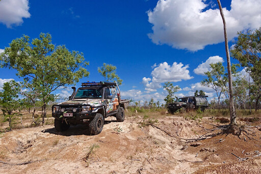
Follow these survey tracks until they essentially run out and start dropping south. It’s slow going, with nothing but GPS co-ordinates to follow, and you’ll eventually arrive at Galah Creek. If you have time it’s an ideal place to stop for lunch and throw a lure across the water to try your luck at catching some barramundi. Crocodiles inhabit these waters, so be sure to take caution near the creek banks.
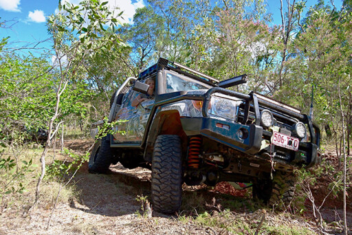
 How deep or how dry this crossing is depends on the previous wet season. Forging the creek at this point is the best option, as it offers a natural rock bar to drive across. The exit is a steep, sandy jump up, with undergrowth foliage to dodge at the same time.
The landscape varies from dry, swampy floodplains to scrappy foliage, all of which you must carefully weave through. This country also provides excellent camouflage for buffalo, and you’ll often see evidence of their existence by the muddy wallows they usually bathe in.
 The journey from Borroloola to the Nimbi Nimbi sinkhole is only 19km, but it’s not to be taken lightly, as you can easily become disorientated when one clump of trees looks exactly like the next. If you lose sight of the lead vehicle there may be times when sounding the horn is required to locate the direction of the vehicle in front. Good UHF radio contact is also essential.
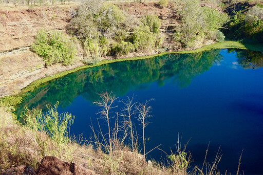
A solid days’ drive from Borroloola will have you pulling up at the sinkhole as the sun goes down. Almost romantically surrounded by spinifex grass and lightly peppered with low-lying trees, this geological phenomenon sits atop open escarpment country.
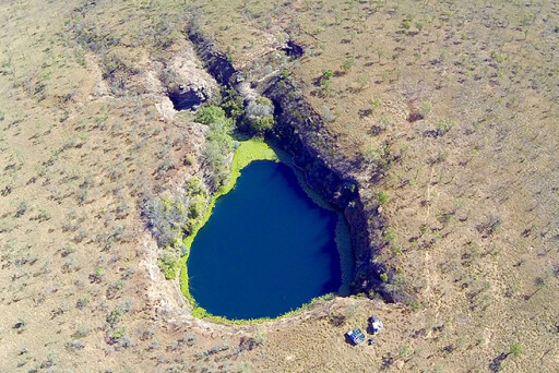 Its size is impressive and the layered cliff faces drop down into turquoise-blue water that’ll take your breath away.
Taking a stroll around will reveal a game trail that completely encircles the sinkhole, where cattle have searched to no avail for an entry point to the water’s edge. On the north-west side there is a ravine you can walk down to get closer to the water source, but you’d need to be an adept explorer to descend the final 15 metres.
 Scientific studies reveal that sinkholes, like Nimbi Nimbi, are formed from ancient lava tubes, yet little is known on how many lava tubes branch off or the fish that inhabit its waters.
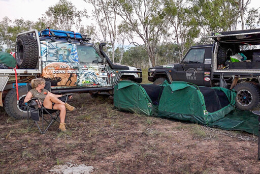
Only experienced 4WDers with extensively set-up vehicles and an expert level of navigational skills should attempt to reach the Nimbi Nimbi sinkhole. Tyre punctures are a very high risk due to needing to forge their own path – up to 15 punctures were relentlessly embedded into the quad-bike tyres throughout the entire trip. For travellers short on time, a helicopter flight to the sinkhole can be arranged from Borroloola.
It’s a hard battle to reach the hidden Nimbi Nimbi sinkhole, but it’s a significant sight that will last forever in your memory.
.jpg )
2
TRAVEL PLANNER
WHERE: Borroloola is a town in the Northern Territory on the eastern side of the Gulf of Carpentaria, 670km south-east of Katherine.
MAPS: Hema’s Australia Road and 4WD Atlas. Google Earth satellite photos should be downloaded prior to departure.
ACCOMMODATION: King Ash Bay Lodge, Borroloola (call Katie on 0477 294 172).
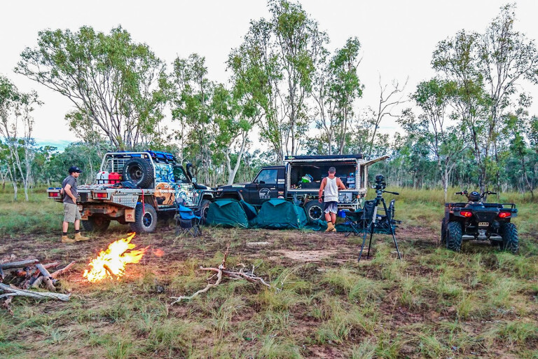
The sinkhole track is completely self-sustaining camping, with no facilities available at all (even the road is optional).
 FUEL AND SUPPLIES: Fuel available at AFD Gulf Mini Mart, Borroloola (phone:
[08] 8975 8790). This is the first servo as you arrive into town, and Leslie and her crew provide mouth-watering meals for dine-in or takeaway. A small variety of groceries are also available here.
RESTRICTIONS AND PERMITS: No permits are required to visit Borroloola. However, permission from the traditional owners is required to visit the sinkhole. Contact Daniel at NLC Borroloola (phone: [08] 8975 7500).
.jpg ) VEHICLE SET-UP: A high-clearance vehicle is required, and the paintwork will get scratched. Also bring along spare tyres, GPS navigation, recovery equipment and
VEHICLE SET-UP: A high-clearance vehicle is required, and the paintwork will get scratched. Also bring along spare tyres, GPS navigation, recovery equipment and
a satellite phone. The trip to the sinkhole isn’t suitable for camper trailers. Experience in remote travel is required, as is being able to use only GPS co-ordinates to navigate. Explorers also need to be self-sufficient when camping, and bring plenty of drinking water, as well as a remote first-aid kit (including snake-bite kit). Don’t travel alone!
GPS LOCATION: The co-ordinates to locate the sinkhole are 12°58’37.39”S and 136°04’09.62”E. Make sure you constantly check your status as you near the co-ordinates to ensure you don’t drive off the ledge if you are approaching when the sun has faded or it’s dark.
Please enable JavaScript to view the comments powered by Disqus.
COMMENTS