Explore SA
Gallery7
Birdsville is a small community, population 100, on the edge of the Simpson Desert in far southwest Queensland. It’s 12km north of the South Australian border at the end of the Birdsville track, 1200km north of Adelaide and 1600km west of Brisbane. Poeppel’s Corner is 171km west of Birdsville.
When to go: Birdsville is always a fabulous travel destination but the national parks of the Simpson Desert are closed from 1 December to 15 March each year.
What to bring: There are no facilities in the desert, so BYO camping gear, food, plenty of water and a satellite phone. You probably won’t need much in the way of extra fuel or spare parts, but check your vehicle’s specifications.
Food and fuel: Food and fuel is available in Birdsville at a number of outlets. A brilliant general store stocks fresh fruit and veggies, meat and dry stores and the pub and the bakery both serve scrumptious meals for your nights in town. For more information, call the Birdsville Wirrarri Information Centre on (07) 4656 3300.
Accommodation: Accommodation is available in Birdsville at the Birdsville Caravan Park and the Birdsville Hotel. In the desert, it’s strictly bush camping only.
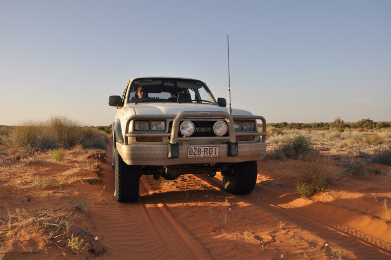
Driving conditions: Depending on the time of year you visit, the tracks can vary from very soft, windblown sand to compacted sand rutted out from heavy traffic. The more southern tracks are less sandy and more clay-based, but the Rig Road crosses some very peaky dunes.
The Simpson Desert Loop
Just 35 kilometres from Birdsville, Big Red is a playground for all kinds of vehicles and their drivers, intent on conquering the legendary dune.
Of course, there’s more to the Simpson Desert than this oversized pile of sand. A galore of tracks and terrains, the Simpson caters for every off road taste – you just need to know where to look. There’s one route that’s a mixed bag of tracks and it’s an easy two or three-day loop returning to Birdsville. The best part? It’s the road less travelled.
The QAA line
Covering the sandy QAA line, the rough and windy Knolls
Track, the surprisingly smooth and straight Erabena Track, the clay-based Rig Road and the recently reopened Warburton Track, this desert loop provides a taste of the Simpson without the time and distance commitment of a full-blown desert crossing.
The QAA line is one of the most popular tracks in the Simpson. Not only is it the main east-west thoroughfare, meeting the well-known French Line at Poepell’s Corner (the junction of the Queensland, South Australian and Northern Territory borders) but it’s the only track into the desert from the eastern edge.
Driving the dunes
Being the largest area of parallel sand dunes in the world, the Simpson’s biggest 4WDing challenge is undoubtedly the climbs. The desert’s 1100 dunes run north to south so crossing them is unavoidable when travelling east to west on the QAA line. The dunes are large and well defined in this area of the desert and the swales are wide and clay-based. The track’s popularity means that it’s rough and rutted with inexperienced desert drivers severely damaging the dunes.
Poeppel’s corner
The QAA meets the K1 line at the Northern Territory border and all traffic is diverted south along the edge of a salt lake before reaching Poeppel’s corner. The original post, surveyed and placed by Sir Augustus Poeppel in 1878, was later found to be in the wrong place. Poeppel’s surveying chains had stretched in the heat, making him wrong by a whole kilometer. A new concrete monument now marks the rightful position, and is used as an informative stop, accompanied by a boardwalk and information boards.
The Knolls Track
40 kilometres along the French Line is the Knolls Track turnoff, where you can leave the main drag behind and have a break from climbing dunes. Heading south, the Wangkangurru sacred sites of the Approdinna Attora Knolls, or Warra-Bullana in traditional language, rise from the clay pan.
The Knolls Track twists and turns through thick gidgee and passes countless hidden campsites. The perfect one is waiting near the WAA line turnoff, about 30km past the Knolls themselves. Here, the sun sets over low, sandy rises and patches of dying wildflowers, translucent in their death but holding the last rays of the day in their distorted petals.
Clifton Hills Station
Turning south, the Warburton track leads travellers out of the maze of desert surveying lines. Big gums and denser vegetation begins to appear as the track flattens and weaves between low blonde dunes, climbing few of them. A sign declares the entrance to Clifton Hills Station. At 17,000 square kilometres, it’s the largest pastoral holding on the Birdsville Track. A beautiful set of decaying wooden stockyards indicates the long history of settler’s habitation and the track is well worn and maintained by the station.
This southern section of the Warburton Track was flooded and closed for most of 2010, 2011 and 2012. This was caused by a few years of unusually high rainfall, in addition to waters from north Queensland flowering towards Lake Eyre. The Inside Track (to the north) and the Walker’s Crossing track (to the east) were also closed during that time, and they only reopened early in 2013. The spindly, dead trees that line the track remain as evidence of the geographically big and long floor.
The Warburton Crossing
The Warburton Crossing itself is almost unnoticeable in the dry. The creek is so wide and shallow that unless you know where it is, you’ll find yourself back on the Birdsville Track without realizing you’ve crossed it.
The Inside Track was once used by drovers transporting Queensland cattle to auctions in Adelaide. The turn-off is 24km north of the Warburton junction and is marked only by a rusty, round drum lid on the eastern side of the main track. A hard left leads 4WDs over red gibber plains and through more floodplains as the track sweeps north towards Birdsville.
An easy drive through picturesque dunes, coolibahs and past the Diamantina’s secluded waterholes is a typical trip along the Inside Track. Pelicans glide over the river and dense groups of flock pigeons flutter through the wind. If you have to dodge an emu, you’ve really hit the birdwatcher’s jackpot.
Birdsville
Whether it’s taken two or three days, Birdsville’s water towers flickering into view are a welcome sight for some. The desert isn’t everyone’s cup of tea and this short loop is a perfect taster to lure in the uninitiated – but a word of the wise, once you’ve done it once, you’ll be hooked.
Birdsville and its famous pub, quirky bakery and well-stocked roadhouse is the reward at the end of the loop. With a sip of a cold beer beneath the dusty Akubras hanging from the main bar’s roof, you’ll be gloating to fellow travellers about a memorable trip through the best of the Simpson Desert.
Please enable JavaScript to view the comments powered by Disqus.
COMMENTS