Explore SA

Gallery9
4x4 Travel Guide
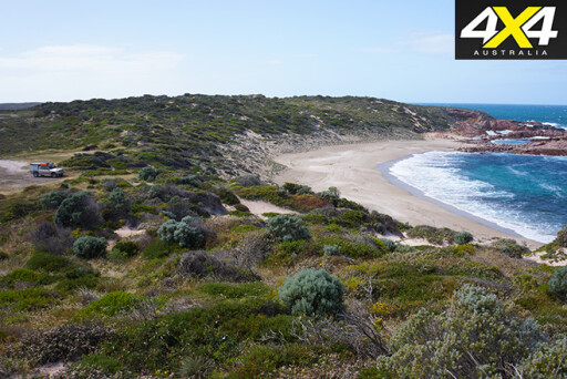
The name isn’t one to win awards or even attract many campers, but ‘Mozzie Flat’, tucked up in a small depression among sand dunes, just back from the beach, is a little beauty for a couple of campers and their vehicles.
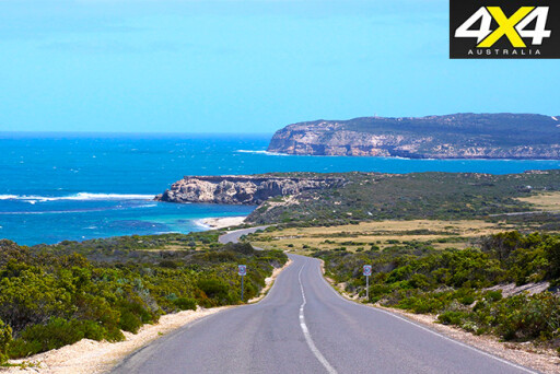
We stumbled upon it as we’d wandered west of Edithburgh along the ‘instep’ of the coast of Yorke Peninsula. The dirt road having first taken us south from Edithburgh along the coast, past Wattle Point and Sheoak Beach, to Troubridge Point and its nearby tall, red-brick lighthouse.
There are lots of cliff-lined bays and soft sandy beaches along this stretch of coast and, while you can launch a boat off many of the beaches, driving much farther along the sand is tricky and fraught with danger. I checked out a number of beaches and, noticing banks of weed hidden under a fine covering of sand, decided it would be a braver man than I who would take up the challenge.
 There’s some good beach fishing, though, to be had here and if you have a small boat or kayak, even better hauls of fish can be expected, with big red snapper being one of the prizes among mixed bags of whiting, snook, sweep and flathead. Most of this coast from north of Edithburgh to Point Davenport is protected in a marine park, but recreational fishing is allowed everywhere, apart from the sanctuary zone around Point Davenport.
There are more than 80 shipwrecks scattered along the Yorke Peninsula coast and among the many reminders of the seafaring days you’ll find in nearly every town around the peninsula’s coast are reminders of those who were lost at sea.
 If you are into history and/or diving, then a good place to start your travels is on the Investigator Strait Shipwreck Trail, which includes 26 shipwreck sites stretching along the southern coast from Edithburgh to West Cape in Innes National Park.
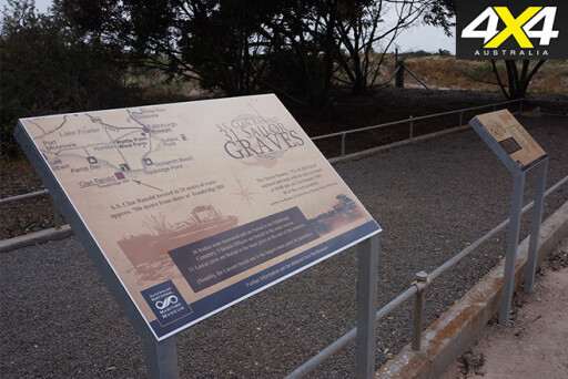
Probably the most famous of these wrecks is the 108-metre-long schooner-rigged SS Clan Ranald, which met its end west of Troubridge Point in 1909, with the loss of 40 lives, making it one of the worst shipping disasters in South Australian history. In Edithburgh’s historic cemetery are the graves of those whose bodies were recovered, while the wreck itself is in 20m of water and makes for a great dive.
West of Troubridge Hill a good dirt road keeps heading along the coast, while a number of 4WD tracks head across the cliffs to fishing spots, small camps and access to the beaches below.
 Just off our Mozzie Flat campsite is the wreck of the Yatala Reef, a 26-metre-long, single-mast cutter that sank in 1981, with the loss of its four crew members. Again, it’s a good dive.
East of Marion Bay and its small village of holiday shacks and a caravan park there is fabulous camping available at Hillocks Drive, which stretches along the best of the south coast for more than 7km. Many small protected bays, wild exposed reefs and rocky headlands along with stretches of surf-pounded beach make this a spot enjoyed by many.
Over the school holidays and the like you’ll need to book, but the rest of the time you’ll be able to easily find a spot for yourself. The Hillocks homestead, where you get your camping permit, has a small store where hot showers and rainwater for drinking is available.
 West of Marion Bay the rugged headlands and high cliffs of the south-western tip of the peninsula are protected in Innes National Park.
We’ve been coming to this place since I was a young lad and, while park regulations may be a little more restrictive nowadays than in earlier times, the place is a delight with many camping areas just a stone’s throw from a protected beach, a rocky headland ideal for fishing or diving, or a top surf spot.
Once again, a marine park protects most of the coast here, but recreational fishing is allowed in all areas apart from the immediate area around the distinctive Chinamans Hat Island.
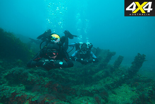 Again, there is some top diving around here, and there are also the wrecks of the Hougoumont at Stenhouse Bay, the Marion at Chinamans Hat and the Willyama, just west of Marion Bay – all in less than 9m of water, so all can be explored by snorkelling.
Our journey along the sole of Yorke Peninsula is over, but we’ll be back – nothing can keep us away!
TRAVEL INFO
 Where
Where
Yorke Peninsula, SA.
Camping
Various sites along coast.
Facilities
Shelter sheds at some campsites. No other facilities.
Hillocks Drive camping area has showers and toilets.
Trip standard
Easy except on soft sandy beaches.
Maps and guides
Carto Graphics map, Yorke Peninsula.
Restrictions and permits
No restrictions; camping permits required for Innes NP.
Contacts and information
Hillocks Drive Camping: www.hillocksdrive.com
Ph: (08) 8854 4002
Innes NP: www.environment.sa.gov.au
MORE INFO
 Edithburgh has everything a traveller requires. Only Marion Bay has a general store and fuel, although towns inland (never far away) can provide the essentials.
There’s some interesting information on the Shipwreck Trail and the wrecks, and also details and camping permits for Innes NP at: www.environment.sa.gov.au.
For more info on Hillocks drive and the excellent camping there, check out: www.hillocksdrive.com.
4x4 Travel Feature
This rugged coastline offers much more than just spectacular camping and amazing views.
By: Miriam Blaker
9
We arrived the day before a forecast of Catastrophic Fire Danger. The adjoining national park had just closed and all campers inside the six campgrounds were evacuated. Some were squeezed into the park where we had booked but many had to find spots elsewhere. We were lucky to secure the last powered site in this tiny South Australian park, barely a week before Christmas. But, as we discovered, with a whopping 700km of coastline, there are loads of low-cost camping options along this pristine coast.
We were camping on the Yorke Peninsula, three hours from Adelaide on Australia’s own version of the Italian boot. However, despite its Mediterranean climate and sparkling beaches, that’s the end of the similarities. Marion Bay is uniquely Australian, abundant in wildlife and right on the toe of this peninsula, a tiny township 7km from the entrance of Innes National Park.
It was here we’d just rocked into, with our trusty D-Max Ute and Outback camper. We’d planned on spending the next day exploring Innes but with the fire danger so high we decided to instead check out other hideaways on this southern coastline.
9
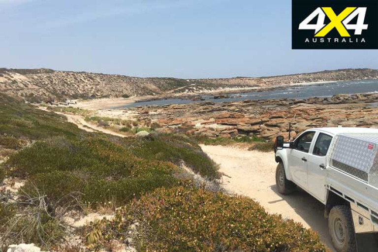
Our destination on the first day was Corny Point, renowned for its surf and boat fishing, and perfect swimming bays. With water on three sides of the southern peninsula a drive through this area means you’re never more than 25km away from a beachfront experience. The beaches range from sheltered lonely coves to crashing surf, and many bush camp spots are tucked in amongst endless stretches of sand, some tracks only accessible by four-wheel drive.
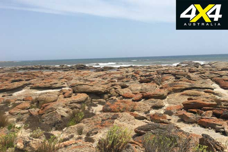
The scenic drive to Corny Point takes in some of these lonely stretches of sand with a spectacular coastal route all the way to Berry Bay. Along the way we passed through Daly Heads, a popular surf break that offers challenging conditions for those who love to ride the waves, and lots of rocky reefs for land lovers to explore.
Gleeson’s Landing close by has great camp spots with a 4WD beach-launch for boats and loads of areas to throw down a swag. Farther on there’s camping available at picturesque Swincer Rocks, where there’s often garfish and squid off the rocks as well as good snorkelling.
9
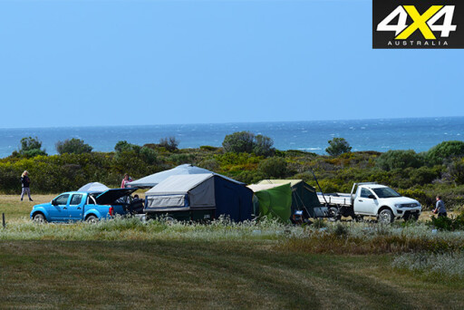
At Gravel Bay on the west coast of the foot on Berry Bay Road, 18km west of Corny Point, you can set up camp on the coastal reserve and at the bottom of the cliff. This is 4WD territory and a top spot for those who love secluded camping and waking up to crashing surf. Driving over a rocky crest towards level ground we came across a couple of campers and stopped to say g’day.
Sue and Andrew are from Adelaide, and they were in the process of securing their camper trailer after the ferocious winds on the previous night whipped their awning apart. Despite their tempestuous night they were in high spirits and were cracking a beer, stoked to be camped with the ultimate ocean view.
Barely 1km south of Berry Bay there’s a tiny secluded bay unofficially called Horseshoe Bay, undoubtedly due to its horseshoe shape. Located below the lighthouse it’s a perfect spot for rock-pool swimming.
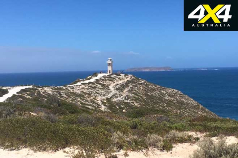
Finally, we arrived at Corny Point, named by Captain Flinders in 1802 who likened it to a growth on the toe of the Yorke Peninsula. Here the beach curves as far as the eye can see. The town was originally established as a place for a lighthouse which was eventually built in 1882. At 12.2m high and constructed from local limestone, the Corny Point lighthouse is worth a stop for a few pics before continuing down this stretch of coast.
9
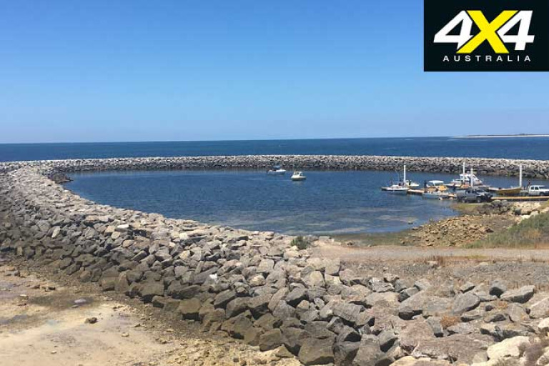
We arrived in Point Turton in time to see local fishermen hauling in their day’s catch. The jetty is a hive of activity in this small coastal town where the turquoise waters beckon, for both fishermen and holiday makers.
In the early 20th century, Point Turton was best known for its limestone flux quarries operated by BHP, but these closed around 100 years ago. Most people these days stay nearby at the Point Turton Caravan Park which nestles in the site of the old flux quarries and overlooks those turquoise waters.
Back at camp in Marion Bay the pace is relaxed. Close by there were fishermen on the jetty catching squid and I was told that from March to June mullet is often caught from the beach. Non-fishermen like us can enjoy the locally caught fish of the day at the nearby tavern, coupled with a South Australian Sav Blanc or a local beer. It’s here that we spent the last dinner of 2019. The tavern also makes delicious wood fired pizza all through the day, and just around the corner the Beach Café offers awesome homemade pies, pastries and coffee.
9
Innes National Park re-opened the day after and we set off early to make the most of our day, starting at the Beach Café to pick up last-minute picnic supplies, and then the Visitor Information Centre to organise our vehicle permit.
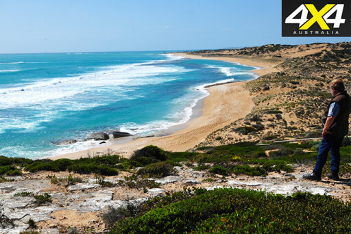
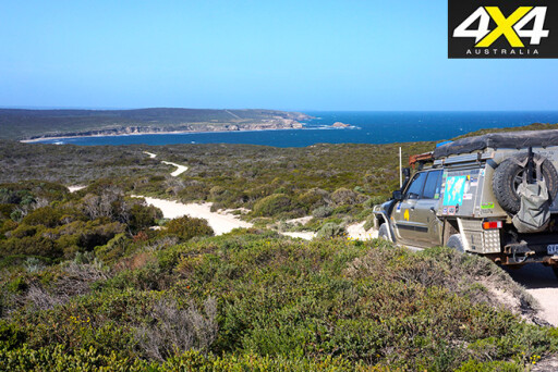
Innes covers an area of 9415ha of coastal vegetation and is the soul of the peninsula. As you crest the road towards Chinamans the view of the dramatic coastline and its curves is enough to make you stop. Shimmering waters, bush and coastline merge and, even though the sky was hazy from the neighbouring Kangaroo Island bushfire, this small national park still packs a big dose of scenic splendour.
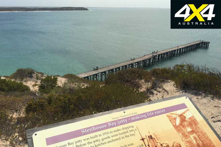
Snaky roads wind through the National Park and we take it easy on the speed, keeping an eye out for and occasionally giving way to both small and large critters. Our first stop was the turnoff to Stenhouse Bay and the picture-perfect jetty that looks out over turquoise waters. This is a favourite spot for fishermen.
Adjacent to the jetty is the 2km Stenhouse Bay Lookout Walk which leads across the clifftops to seven lookout points. The well-marked loop trail includes signs and stories of the mining era and the views from each of the lookout points are simply breathtaking. Watch out for the wildlife, though. At one stage we had a couple of emus on the tracks accompanying us, our own personal guides it seemed.
9
Farther along West Cape is the perfect place to stop for lunch with picnic shelters that overlook a magnificent view. It seemed the wildlife was following us as, underneath our picnic table, two stumpy-tail lizards had taken up residence. One was so curious I thought it was going to climb up on my lap.
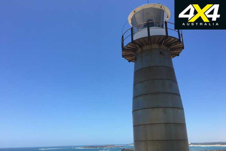
After lunch we enjoyed an exhilarating 30-minute trek along cliff tops to the extraordinary looking and fully automated West Cape Lighthouse; this was built in 1980 completely from stainless steel. Along the way there are spectacular coastal views ranging across the Spencer Gulf Marine Park and offshore islands.
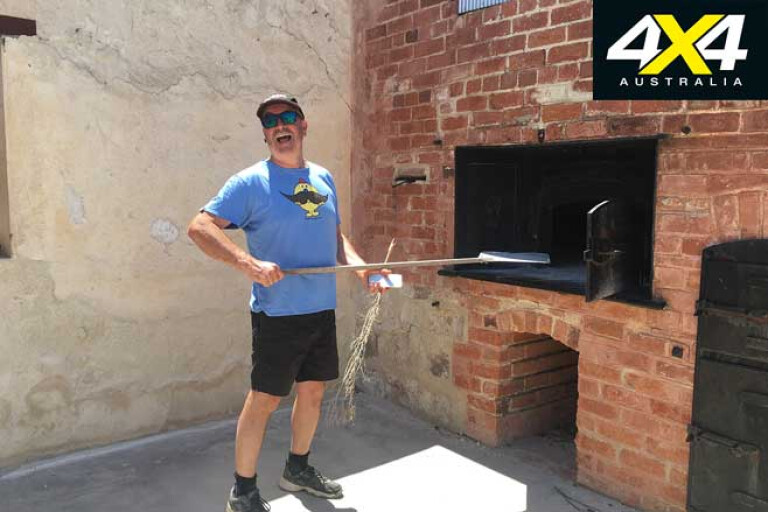
Not far from West Cape is a 2km walk to historic Inneston. This was once a bustling gypsum mining town and in the early 1900s was home to about 150 miners and their families. Today it’s like a ghost town, and abandoned, but you can stay overnight in one of the fully self-contained and restored heritage buildings. Or simply explore the area and all the ruins that surround the glistening saltwater lake where mining once took place.
9
Inside the Baker’s Oven there were, so the signs say, more than 130 loaves of bread baked daily in the 1920s. Alas, no smells of baked bread when we visited, just lonely picturesque ruins that stand as a reminder of the era. Oh, and pesky March flies! They were so intent on biting that I ended up running the last 100m back to the D-Max to escape them.
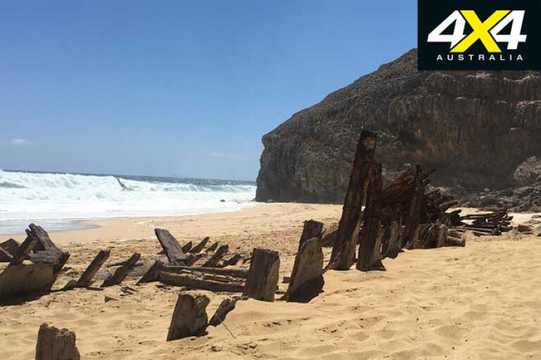
The remains of more than 40 shipwrecks are scattered off the coast of Innes and within the Southern Spencer Marine Park. At the top of the Ethel Beach carpark you can read about the wreck of the Ethel that came to grief here back in 1904, and see the original anchor, before walking the 130 steps down to the shoreline.
Here you’ll find the remains of the Ethel and the Ferret. You can feel the force of the sea and, amid the pounding of the waves and the dramatic overhanging cliffs, you can’t help but feel small and humbled. No wonder this is considered such a treacherous coastline.
9
Farther along, taking the turnoff to Shell Beach, is one of the best swimming spots in the National Park. Located at the far end of Shell Beach, around the corner of the rocks, is the Blue Pool. With protected rocks forming nature’s own swimming oasis, it’s the perfect spot to cool down on a hot day.
Every October long weekend the Yorke’s Classic is held in Innes National Park, one of Australia’s most prestigious surfing events. It’s no wonder that surfers love Innes. Whether you’re a surfer or a spectator, Innes is filled with hidden gems from Pondalowie Bay to Gym Beach, from vertical cliffs to small coves, and secluded beaches that house relics of wrecks. Below the water scuba divers can explore some of the remnants of these underwater time capsules in the Southern Spencer Gulf Marine Park.
There’s no phone reception in the northern part of the park, but who really cares. Entry costs $11 per vehicle and is worth every cent with seven campgrounds, roads, signs and boardwalks in an exceptionally well-maintained NP. Perhaps the best part of Innes National Park is simply that some of the best views are accessible literally right outside your 4x4’s door.
Contacts
For bush camping on the Yorke Peninsula book your camping permit at www.visityorkepeninsula.com.au or telephone 1800 202 445. The permit is transferable between all 19 sites allowing you to move around the Peninsula and experience spectacular coastlines and magnificent beaches.
Entry to Innes National Park can be organised online at parks.sa.gov.au or in person at the Visitor Information Centre, located just inside the park. Within Innes National Park there is no drinking water or supplies, so be prepared and take all your own food and water.
Please enable JavaScript to view the comments powered by Disqus.
COMMENTS