Explore
Gallery9
Part two – Trekking the southern cliffs
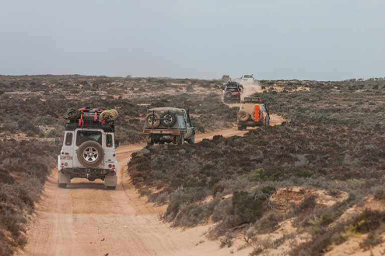
As we crossed the border into South Australia, the cliffs got lower and the many small coves and bays became more accessible, but the sand was softer and the scrub thicker. 4X4 Australia magazine’s trek across the Great Australian Bight continued, but not easily, as we soon discovered.
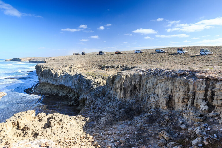
The long arc of beach swept away from our vantage point, its far end lost in the sea mist of mid morning, while the tall dunes of the Yalata Sandpatch morphed into the dull covering of clouds that stretched across the sky from horizon to distant horizon. We were standing on low cliffs overlooking Twin Rocks Beach at the Head of Bight, in the Yalata Aboriginal Lands, the whale watching facility that some people would know from this region, a few kilometres west of us.
We had permission to enter this normally closed area and run to the beach south from here to Hiltons, a camping spot that is normally the closest access to the beach. Hiltons, along with a few other selected sites further south, are popular fishing camps for those keen anglers trying their luck along this wild, surf-smashed coast. Access and camping is controlled by Yalata Land Management rangers and a permit is required to camp and fish this coast (see our travel planner).
9
Below us Eyre Well, and just a little further inland, Illcumba Well were hidden by small dense stands of low green scrub. Illcumba is one of the traditional waterholes and meeting places for the Aboriginal people, while Eyre Well was where the explorer Edward John Eyre found a life-giving soak for himself and his party during their 1840 ordeal of crossing the Bight from Streaky Bay to Albany.
We dropped down the rocky shaly cliff and poked our way between some prickly scrub and drove onto the seaweed-strewn beach. Above and around us whirled hundreds of small birds – mainly swallows – with more joining them as we drove along the sand, disturbing their early morning feeding activity. A large flock of terns lifted off the wet sand in front of me, swept out to sea in a big arc and landed on the sand again behind the last vehicle in our convoy. A dingo, trotting along the sand, looked back over his shoulder and on seeing us sprinted smartly into the dunes and quickly vanished.
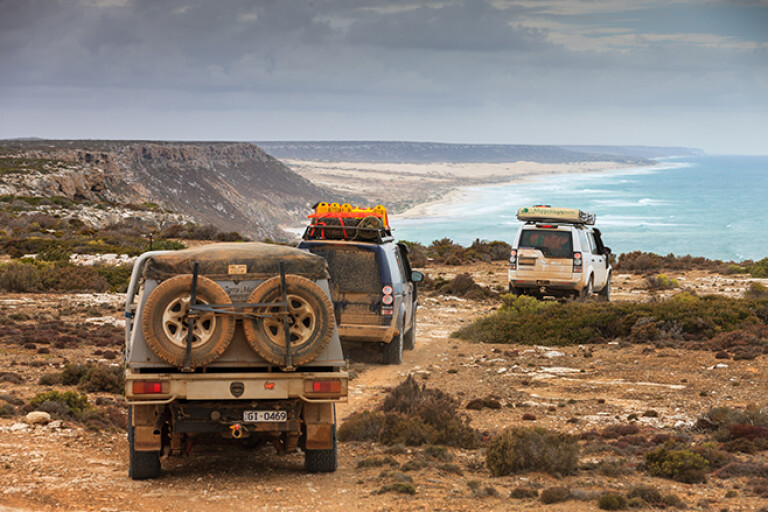
Our mid-morning enjoyment of nature and its delights quickly came to an end as the soft clawing sand slowed our wheels and taxed our engines. I thumbed the gear paddle down to second - low and growled along the beach trying to find an easy route, but the whole width of the beach seemed to be one and the same – and that was soft!
9
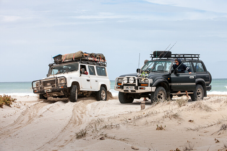
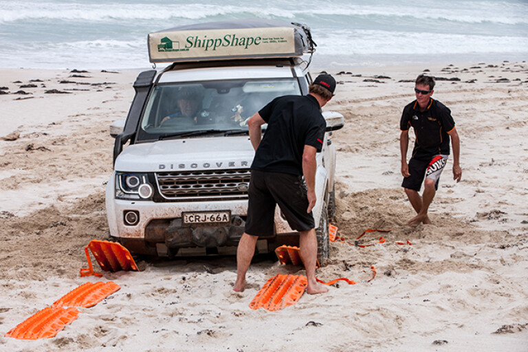
The chatter over the radio indicated a couple of vehicles bogged behind me and as I slowed even further I met the same fate. Slipping out of the vehicle we started a recovery with a few Maxtrax, a wave suddenly washing around the tyres of the Disco and the vehicle behind me. It’s surprising how everyone’s pace steps up a gear or two when waves begin washing around vehicles and for a while there was frantic activity with shovels and tracks until the vehicles were back up above the waves.
Then we went back and helped the others out – there being six other vehicles bogged along a 1km stretch of beach. Some were being snatched out by Ed’s hard-working Cruiser ute, or the worked-over 200 Series from Safari, while others were using a veritable highway of Maxtrax to get going.
The next couple of kilometres along the beach was like that – growling engines with slow and tedious forward movement followed by a sinking feeling as one tried every trick in the book to keep the vehicle in some way moving forward. By now we were pretty well practiced and the Maxtrax were never far away; a bit of digging, a Maxtrax laid in front (or sometimes behind) each wheel and then a dab of the throttle to get up onto the top of the Maxtrax, before flooring the accelerator and heading for higher, drier or firmer land.
9
By the time we got to Hiltons everyone was glad to drive off that beach. We stopped and breathed a collective sigh of relief, sorted recovery gear and had a bite to eat and a brew.
We’d left Eucla a couple of days earlier after changing a few of the crew over, refuelling the vehicles and filling with water. The first day out from that small hamlet of civilisation was a big one.
The main highway hugs the cliff on the SA side of the border for quite some way and while the cliffs – the Bunda Cliffs along this section – are spectacular, the bitumen is at most a kilometre or so inland. We wanted nothing to do with the blacktop, so our track had first taken us through the small Eucla National Park to cross the SA/WA border at the cliffs above the Merdayerrah Sandpatch before we swung inland and picked up the old highway which strikes arrow straight across the Nullarbor Plain and through the rather unsurprisingly named Nullarbor National Park.
This good dirt road is in far better condition now than when it was the only route across the Nullarbor, which was realigned and bituminised on the SA side in 1976 – the WA side was completed seven years earlier. We travelled it a few times in the late ’60s and it was a horror stretch.
9
One of the things we did notice out here was that with the area becoming a park and the grazing infrastructure falling into disrepair, especially the water tanks and the like, the number of kangaroos we saw across these flat plains went from scarce, in the grazing lands on the WA side of the border, to absolutely zero within the park. We only again saw ’roos when we left the park further east.
We took the time to stop at the old Koonalda homestead, which now has a non-descript camping area nearby. For many of us the highlight of this visit was the graveyard of the hundreds of old vehicles that didn’t make it across the Nullarbor back in the days of the dirt highway. The homestead built in 1938, mainly from railway sleepers dragged from the Trans Australian Railway Line – 80km north – has been renovated by National Parks.
We also took the opportunity to head out to Koonalda Cave, 5km north of the homestead, which was once the property’s water supply. Entry to the cave is prohibited, but deep in its dark depths, ancient scratching by Aboriginal people, estimated to be 20,000 years old, have made this cave a very significant archaeological site.
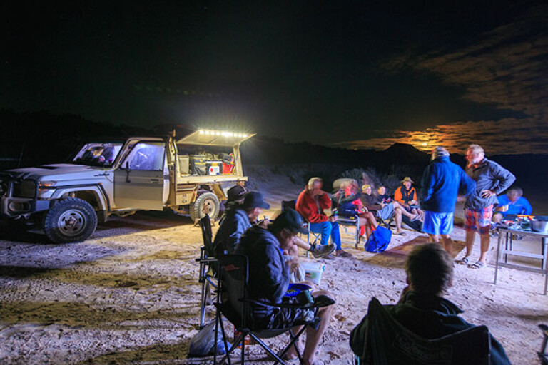
That night we camped just back from the Bunda Cliffs south of the Nullarbor Roadhouse, before heading to our meeting with the soft sand at the Head of Bight. Our route from Hiltons then took us behind the beaches along Coombra Track and through the Yalata Aboriginal Lands until we got to the track heading south to Dog Fence Beach.
9
This track, with deep bulldust patches in places, runs right beside the dog fence as it begins its journey north and then east through SA and along the SA/NSW and NSW/Qld borders to end in far away Queensland. Some say it’s the longest man-made object in the world and its job is to keep dingoes out of the more settled pastoral areas of south-eastern Australia. How well it does that probably depends on your point of view and whether you are trying to run sheep anywhere close to the fence.
Our camp that evening was a beauty, tucked high on the edge of the Ocock Sandhills, just east of the fence. Dense scrub protected us from the wind, while the view took in a sweep of beach and lines of surf.
This is part of the near 400 sq km Wahgunyah Conservation Park which stretches along the coast from the Yalata lands to near Fowlers Bay. Behind the sweep of beaches, coves and cliffs the Ocock Sandhills run into the Wonginya Sandhills which transforms imperceptibly into the Chalgomnippi Sandpatch, making for one impressive mass of bare white dunes.
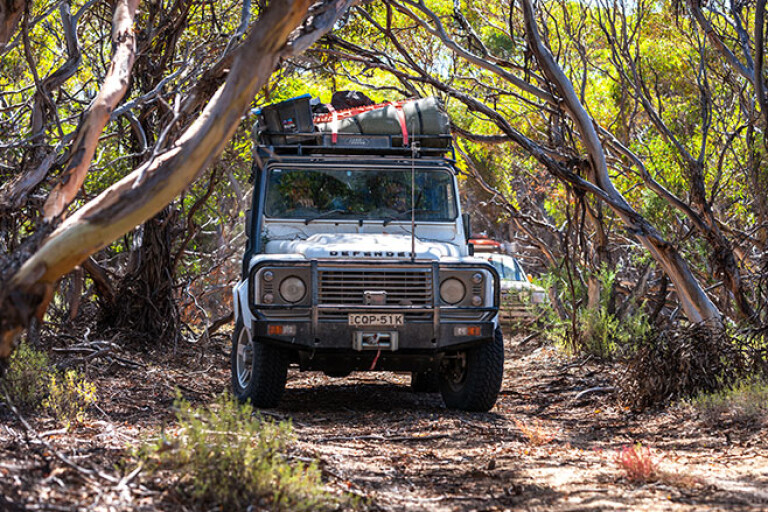
Next morning we followed a track deeper into this world of sand and windblown peaks and after a few kilometres came to a dead end where the beach south was being ravaged by a high tide. We tried to find a way through the scrub that bordered the dune system, but ended up backtracking a short distance where a track took us inland to some old ruins. Turning back towards the dunes, we passed Wahgunyah Well before again getting immersed in some thick scrub and tall stands of mallee trees. A storm had savaged the area sometime recently and we had to clear low overhanging branches before we broke out on a more open and easier track.
9
I’ve been through this section east of the Dog Fence three times now and never once followed my old route – in fact, I’ve never been able to find it. We have seen the ruins and the old well before, though; the shifting sands change everything as they push inland, enveloping tracks and scrubs in their relentless march north.
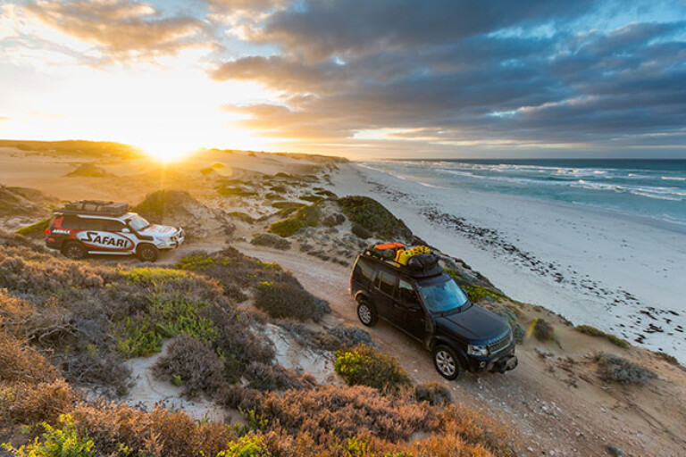
Time was slipping away so we continued east, stopping at spectacular Cape Adieu; like many places along this coast, it’s named by the French navigator, Nicolas Baudin, when he passed by in 1802. That night’s camp was at delightful Cheetima Beach and while there was nobody around apart from our group, we were out of the park and starting to get into more settled districts with grazing and cropping country inland behind the dunes.
We stuck close to the coast the next day as we headed to Wandilla Bay and then the protected Mexican Hat, before climbing Scott Point for a great view of the coast both to the east and west. Dropping off the headland we hit the sand at Scott Bay and cruised around the arc of beach ’til we found a track that cut inland over some very tall steep dunes. In this mini-Sahara of windblown sand we couldn’t help but have a short play – all for the cameras of course – before we slipped into the small village of Fowlers Bay.
Eyre had camped here in 1840 and after being resupplied by his support ship, set out to try and cross the Bight. He commented on the whale bones scattered along the bay, the result of this protected bay being used by the whaling ships of the day as a base for their operations. Today the bay’s main attraction is the nearby beaches and the town’s jetty which offers great fishing, day or night.
9
A day’s travel further east across rocky headlands, around salt mashes and some of the best surf beaches to be found in southern Australia, found us cruising along a relatively easy beach and cutting inland over some low dunes to a protected strip of sand on the southern side of Tourville Bay. In the southern half of the bay, tidal channels wind through a forest of mangroves, the most substantial of which is Davenport Creek, which just happens to have a strip of white sand along its southern edge. This is a popular spot for locals as the protected waters offer good fishing for whiting and flathead while the calm water is good for paddling a canoe or even for water skiing. You can camp nearby – but the mozzies can be thick, as we discovered!
From here we were back in civilisation, relatively speaking, and after a bush camp above the rocky shores of Point Brown, south of Ceduna, we cruised into the diminutive town of Baird Bay where we met with Alan and Trish from Baird Bay Ocean Eco Experience. This was the swansong for the trip with the couple offering one of the best, if not the best, wildlife experiences you can have in Australia.
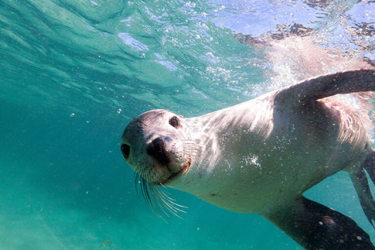
Just offshore and reached by Alan and Trish’s specially built charter boat is Johns Island, now home to approximately 100 Australian sea lions. Alan anchored the boat just offshore from the island (the island is a conservation park and landing is not allowed) and the small beach that is the main nursery area for the sea lions.
9
Within a minute a couple of young sea lions were around the boat and we slipped into the shallow water to join them. It’s about then you realise that humans are ungainly and awkward in the sea when compared to these delightful animals as they barrel-roll around you, swoop down to the sand just below you, look up enticing you to follow, then zoom up to your facemask and then barrel roll away to start it all again. If you don’t pay them any attention they’ll more than likely nibble on your feet or pull your hair, barrel-rolling away as you turn towards them. It is absolutely fantastic!
Part of this charter may include swimming with a pod of wild dolphins and while we did see a small group, they weren’t in a playful mood and left us floundering and alone in their wake. Luckily the sea lions are a lot more friendly and playful and while I’ve done this swim three or four times, it is one I’ll never get sick of.
That evening Macca cooked up a spaghetti marinara with the freshest seafood imaginable – what else could you expect when you are in the heart of one of the best seafood regions in Australia? It was a fine ending and a fitting celebration to our journey across the Great Australian Bight – surely one of the best, maybe the best, coastal 4x4 trips in Australia!
Want to see more from our trip? Check out the below videos:
- The Great Australian Bight adventure: part one
- The Great Australian Bight adventure coming soon
- The Great Australian Bight Adventure Teaser II
- The Great Australian Bight Adventure Teaser III
- Big Bight Adventure: Bush Mechanics
- How to prepare for a 4x4 trip
- How to beach drive
- How to 4WD in a convoy: radio communication
Get the latest info on all things 4X4 Australia by signing up to our newsletter.
Please enable JavaScript to view the comments powered by Disqus.
COMMENTS