Explore NSW
Gallery5
Stockton Beach has, for many years, been a popular destination for camping and sand-dune hopping, but unfortunately, due to two large storms in recent years, the landscape in this area has been badly affected and, as a result, there’s now limited access to what is regarded as the largest moving sand dune system in the southern hemisphere.
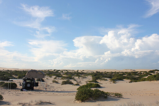
When you first encounter this beach you will immediately be struck by its scale and the formidable dune systems that stretch for as far as the eye can see. This beach also has many remnants of history deposited over the millennia, including ancient Aboriginal shells and numerous shipwrecks.
 More recently, interesting objects from WWII defence systems against a feared invasion by the Japanese can be found along the beach. One of the beach’s most famous attractions is ‘Tin City’, a cluster of 11 shacks used by fishermen since the 1930s and subsequently made famous by appearing in the 1979 movie, Mad Max.
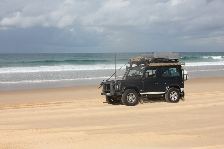
Located on the Tasman Sea, Stockton Beach starts on the northern side of the breakwall that protects the entrance to Newcastle Harbour in Stockton and continues for 32km in a north-easterly direction to Anna Bay in Port Stephens.
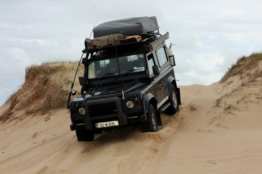
For those who missed the opportunity to explore the unique sand dune system before parts of it were closed off to the general public, it was not unlike driving through the Sahara Desert, particularly in the dunes. With some dunes towering up to 100-feet tall, it certainly made for a great weekend getaway.
Prior to 2012, Stockton Beach, with its endless dunes, was the perfect environment to improve your sand driving skills and experience beach camping like nowhere else along the NSW coastline. However, things have changed significantly since then.
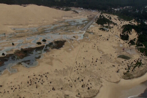 Unfortunately, the privilege of driving a 4WD through the back dunes of Stockton Beach came to an end following the devastation caused by super storms in 2012 and 2015. In order to facilitate the natural rebuilding of the frontal dunes, new rules dictate where enthusiasts can now take their 4WDs. Luckily, all is not lost, and there’s evidence of regeneration of the frontal dune systems on Stockton Beach.
So, how bad were the storms that pretty much changed this entire landscape? Well, the first major storm in 2012 was the result of a serious southerly low that pounded the beach with swells of ocean 2.3-metres tall. As a result, the ocean overran the frontal dune systems, filling the swale systems behind the dunes with salty water and creating large pools of salt water.
The back beach and swale areas between the Lavis Lane and Gan Gan Road entrances are now closed to 4WDs. The 2012 storm also caused gaps, traditionally used by 4WDs as entry points into the back dunes, to become vulnerable.
Continuous driving over these entry points caused the surface to deflate and, as a result, made it easier for storm swells to enter into the back dunes and cause further damage. So, prohibiting vehicles entering the back dunes gives them the time needed to recover.
 Grass and the spinifex are the only things holding the dunes together, and it’s obvious the areas along the frontal dunes that survived were the ones with strong vegetation; whereas the areas where the ocean broke through had limited vegetation. So, it’s understandable why it’s imperative to not drive on the existing vegetation.
In its heyday, Stockton Beach attracted between 1500 and 2000 vehicles per day. This, in part, increasingly added pressure on parts of the fragile dune systems that naturally act as a defence against the approaching swells.
To add fuel to the fire, the devastating storm in 2015 that battered this fragile coastline had further devastating impacts on the conservation lands. This storm added to the previous damage of the frontal dune system, but it also resulted in the destruction of cultural sites.
Other issues resulting from this storm included saltwater killing off vegetation, large water pools that made it difficult for 4WDs to pass in places, and the reduction in beachfront by up to 15 metres – making it hazardous for 4WDs to drive along at high tide.
This resulted in the development of a plan of management for the area, and a number of key recommendations are being implemented under the direction of The Worimi Conservation Lands Board of Management and the National Parks and Wildlife Service.
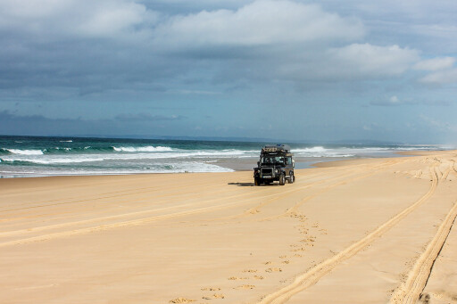
 However, all is not lost. The beachfront and Recreation Vehicle Area are open for 4WDs, which means you can drive on the beachfront between what’s left of the Sygna shipwreck in the south and the Gan Gan Road access frontal dune crossing in the north. Due to the storm damage, all dunes, back beach and swale areas between the Lavis Lane and Gan Gan Road entrances are closed to 4WDs.
So, driving behind the beachfront is only permitted along defined routes to and from WCL designated vehicle accesses (Lavis Lane and Gan Gan Road), in the Recreation Vehicle Area and along defined routes (including across the frontal dune) to and from Tin City.
MOREdestinations
Don’t be too disappointed about not being able to freely experience driving on the large dunes, as you can still test your dune-driving skills in the designated 3.5km² of the Recreational Vehicle Areas. There are also a number of commercial touring companies that access the high dunes in the lands south of the Gan Gan entrance. Make sure your vehicle is registered and display a valid Worimi Conservation Land vehicle permit.
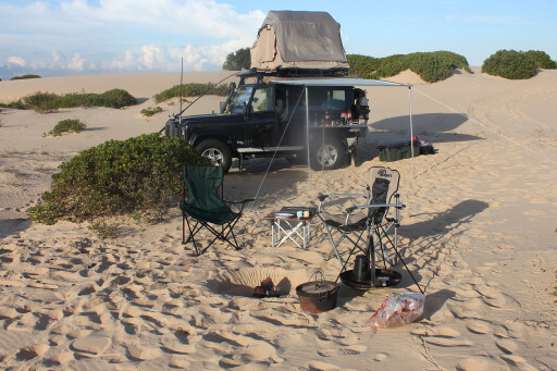
Other than beach driving, one of the other big changes being enforced on Stockton Beach are regulations around camping. Currently, camping is no longer permitted, even if you want to just pull up on the beach, do a spot of fishing, and throw out your swag.
 The draft plan of management identified a number of issues with the damage to dunes and coastal vegetation that arose from an increase in unregulated camping over the years, and this has led to a ban on camping since the last storm. Previously, you could cruise up the beach in your 4WD and camp anywhere you liked, but this is no longer the case.
This practice of camping wherever you liked led to issues concerning rubbish and toilet waste. As a result, these concerns raised by local stakeholders, combined with the storm damage, are now being addressed by providing designated camping areas in the future. Details are expected to be announced before the end of the year as to what type of camping will be available.
 It is understood the designated camping areas will be located south-west from Tin City and will incorporate a total of 30 designated campsites with a maximum of eight per site, but this has yet to be confirmed.
Despite all of the area’s restrictions, there are still plenty of things to see and do on Stockton Beach. Driving on the beautiful Stockton Beach is still one of the most popular family activities on the Worimi Conservation Lands, and there’s plenty of history to learn about in the area. Just keep in mind that sections of the beach can be hazardous at high tide.
Visitors are now advised to avoid driving along the beachfront one hour either side of high tide. But don’t let that put you off. The southern hemisphere’s largest mobile sand dune system provides a dramatic backdrop for 4WD day-trippers. It’s disappointing that camping isn’t an option, but indications are that this will change in the very near future.
TRAVEL PLANNER
WORIMI CONSERVATION LANDS
The 42km² Worimi Conservation Lands are made up of three reserves: Worimi National Park, Worimi State Conservation Area and Worimi Regional Park. These are co-managed by the registered Aboriginal owners and the Department of Environment and Conservation NSW.
CAMPING
Camping isn’t permitted on Stockton Beach, but announcements will be made before the end of the year about the new arrangements. The best place to get the latest information about Worimi Conservation Lands is at: www.worimiconservationlands.com
EMERGENCY NUMBERS
Should you experience any issues on the beach, take note of the distance markers located at 2km intervals between the Gan Gan Rd and Lavis Lane park-entry points. In an emergency dial 000, or if there’s no mobile reception try 112. If calling from the beachfront, advise operator of closest distance marker (markers aren’t to scale).
BEACH PERMITS
Annual and three-day beach vehicle and recreational vehicle permits are available from the following locations:
BP Service Station: 135 Gan Gan Road, Anna Bay, NSW, 2316
Tackle Power: Unit 2/1 Mangrove Road, Sandgate, NSW, 2304
Out of Town 4WD: 65 Northville Drive, Barnsley, NSW, 2278
BP Service Station: Cnr Richardson and Nelson Bay Road, Salt Ash, NSW, 2318
ARB: 89 Griffiths Road, Lambton, NSW, 2299
Port Stephens Visitor Centre: 60 Victoria Pde, Nelson Bay, NSW, 2315
Metro Service Station: Cnr Nelson Bay Road and Lavis Lane, Williamtown, NSW 2318
NPWS Hunter Coast Area Office: 12B Teramby Road, Nelson Bay, NSW, 2315
GENERAL RULES
Fires: Gas barbecues and cookers can be used, but fires aren’t permitted.
Dogs: Dogs must be kept on a leash at all times and are only permitted on the Gan Gan entrance road and on a 3km section of beachfront south from the boundary with Birubi Point Crown reserve at the north-eastern end of the WCL.
Beach swimming: WCL beaches are unpatrolled and have strong ocean currents. Birubi Beach is the closest patrolled beach. Swimming in the ocean off WCL is not recommended and is undertaken at your own risk.
Parking: Car and trailer parking at Lavis Lane and Gan Gan Road entrances.
Toilets: There are no public toilets on WCL. New facilities are planned for the Lavis Lane entrance.
There are no rubbish disposal facilities on WCL, so please take your rubbish with you when you leave.
CODE OF CONDUCT FOR BEACH DRIVING
A speed limit of 40km/h applies, or 20km/h within 100m of pedestrians or vehicles. Give way to pedestrians at all times, and avoid reckless driving. Don’t drive over vegetation and help keep dunes intact by following previous tracks. Also, don’t drive over shell accumulations as you may damage cultural sites.
THINGS TO SEE
The Shacks or Tin City are a collection of huts built by fisherman over the years. You can find them some 10km down from the top of the beach.
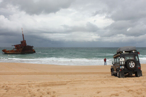
Keep an eye out for parts of the Uralla shipwreck that got into difficulty in 1932. There are also numerous WWII defences in the form of tank traps, and if you are lucky you may also see the wreck of a crashed Sabre jet which protrudes through the sand every now and again. The remains of the Sygna shipwreck that ran aground in 1974 can be found approximately 6km from Lavis Lane.
You will also see numerous Aboriginal midden sites that are of cultural significance.
Please enable JavaScript to view the comments powered by Disqus.
COMMENTS