Explore QLD
Gallery13
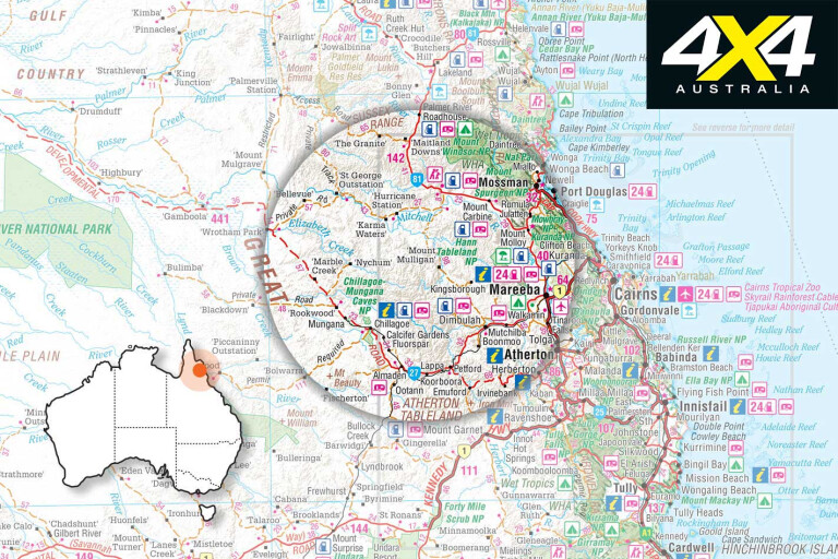
MAREEBA, 60km east from Cairns, is situated between the wet tropic’s eastern coastal range and the Great Dividing Range to the west. The rich farming region is north of the Atherton Tablelands’ volcanic province and is the gateway to Cape York Peninsula and the northern Gulf country. The Mitchell River marks the historic border of the two regions.
The region has many attractions – a rainforest, waterfalls, historic towns, mining sites and bird watching – and is home to more than 430 species of birds, more than anywhere else in Australia. For many travellers heading to the Cape or ending a Gulf adventure, Mareeba is the place to pull up stumps for a few days. The local rodeo ground has free camping, which is pretty much packed out in the dry season; but other parks make up for this shortfall.
13
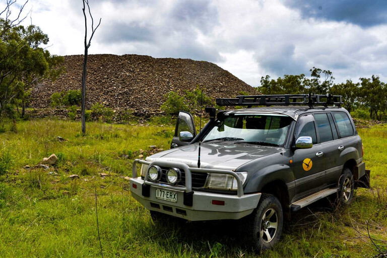
I’ve lived in Mareeba for 15 years and I’m still exploring much of what the region has to offer. My wife and I get out a fair bit on day tours, visiting historic places and natural attractions. Recently, we headed out to the indigenous-owned Kondoparinga Station, 129km north-west from Mareeba on the Wheelbarrow Way, via Dimbulah.
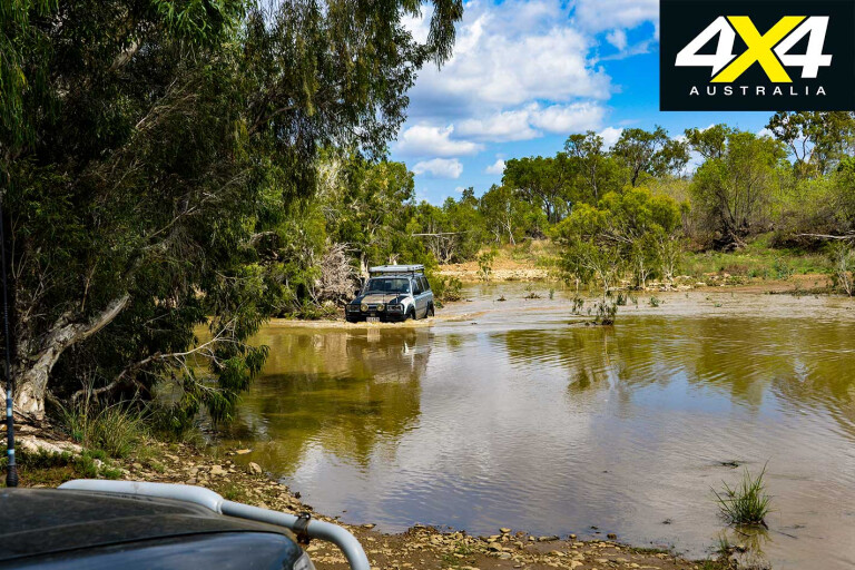
Our plan was to do a full circuit from the station to the Mulligan Highway and return via Mount Carbine, but an early start to the wet season had dumped near 100mm rain and the Old Cooktown Crossing on the Mitchell River was reported to be “touchy”.
The drive to Dimbulah traverses rich farming country, with cattle, mangoes, avocados, limes, vegetables, grapes, hay and more produced in these wide valleys of the Great Dividing Range. Increasingly, rugged cattle country is encountered about 20km west of Dimbulah, where signs warn that this is private property; but, fear not, the entire road is gazetted, though there have been attempts made to close it.
13
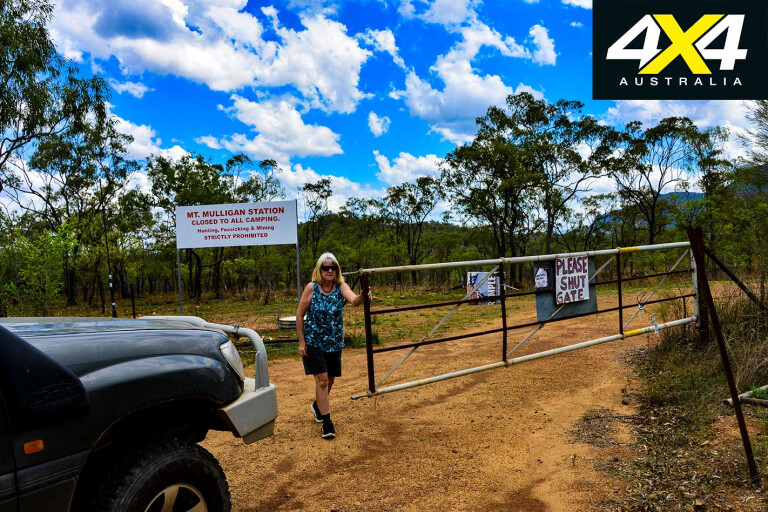
Mount Mulligan Station has been purchased by developer, Chris Morris, who has begun the construction of a $5 million tourist resort, with more planned for other attractions in the area. He has also purchased the Tyrconnell Mine – previously offering accommodation and camping for visitors – with plans to spoil the rich and famous there. Hopefully, he doesn’t overlook cashed-up grey nomads, either.
MOREMount Mulligan
The future of the Tyrconnell Mine is uncertain, as there’s now a locked gate at the entrance. Locking up areas is wrong, especially when our population is expanding and more people are seeking bush escapes.
13
A few years ago the previous owners of the mine were gifted $300,000 by taxpayers for the construction of period cottages and campgrounds and the maintenance of the heritage-listed treatment plant. That was done, but now we are shut out. All is not lost, though, as the region still has many attractions open to visitors, including some of the most amazing mountain views.
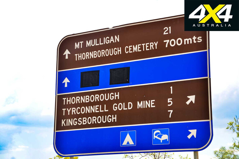
The bitumen ends 12km north of Dimbulah, but the dirt had just been graded and was in excellent condition; although, every creek crossing was running from a storm the previous evening. Out first stop was at the Thornborough Cemetery, just after the Tyrconnell Mine turn-off, where the early pioneers of what was once one of the richest gold mining fields in Australia are buried.
About a quarter of the graves are etched with dates that range from 1877 to 1927, with one particular grave holding the body of 20-year-old Victor Cummings, a coal miner who was killed in the Mount Mulligan mine disaster.

13
Another headstone of note is of the five Murphy children, all whom died within 11 years of each other from 1899 to 1910, aged seven months to 11 years. The Murphy family owned a hotel at Kingsborough and later at Pinnacle Creek. Many children are buried in the old cemeteries, a testimony to how harsh life was in the bush back then.
James Venture Mulligan reported gold on the Hodgkinson River, east of Mount Mulligan, on January 17, 1876, which had been named in his honour by explorer Frank Hann. A rush ensued after Mulligan reported the new field on March 16, 1876, when claiming the government’s 10,000-pound reward for finding payable gold.
Thousands of wide-eyed hopefuls rushed the Hodgkinson River from Cooktown and Croydon, and more than 2000 Cooktown diggers were marooned on a flooded Mitchell River for weeks and ran out of food – they were to be disappointed, as the surface alluvial gold soon ran out.
13
The best gold was under the ground and required heavy mining equipment and investments. Rum-fueled diggers rioted and went on the hunt to lynch Mulligan, who had set up a store. He fled but later returned when the mob calmed down.
Big companies took over the field and sank shafts and set up treatment plants. Getting heavy equipment onto the field was a feat in itself, as it was hauled in by horse-and-wagon crews up the “Bump Track” from Craiglie at Port Douglas, via Mount Molloy and beyond to the Hodgkinson.
Many small miners also did okay by sinking shafts down hard rock and finding rich veins of gold, turning them into instant millionaires. There were dozens of mines on the field ranging from small “shows” to huge sites like the Tyrconnell, Beaconsfield, Northcote, Thornborough, Kingsborough, Lizzie Redmond and General Grant.
13
Much of it is still there, a reminder of a time when people lived in rough iron-clad or bush timber structures. There were pubs, hotels and roadside shanties that, judging by the piles of broken bottles, did very well indeed. The evidence is in the epitaphs on the gravestones of those who could afford them; others are buried in unmarked graves, some fortunate enough to have stones placed on top by family or friends.
Thornborough had a population of some 2000 people, but the only building still remaining is part of the old Canton Hotel. It’s occupied and trespassers aren’t welcome. Down the road a little, the Tyrconnel Mine’s poppet head and buildings stand sentinel-like on a high hill overlooking the Hodgkinson Field.
The maintained road passes it and, after dipping out of Explorer’s Creek, it climbs up a high range from where an unmarked lookout overlooks the now-silent complex of the still-intact Tyrconnel plant.
13
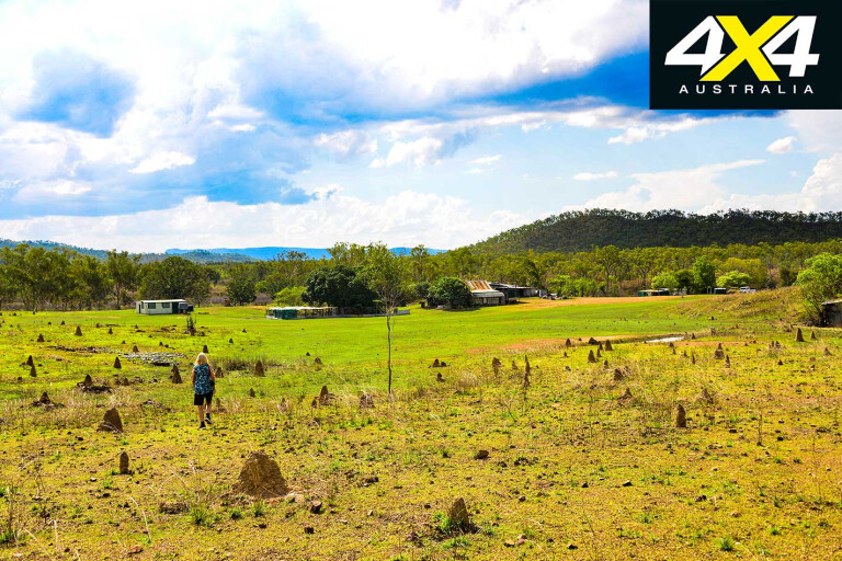
Beyond the Kingsborough Cemetery – to your right, on top of the range – the road overlooks Caledonia Creek, where a dam built in 1901 holds 20 million gallons of water. It kept the General Grant mine going, and the mine now stands out on the edge of a steep hill (oddly, its leaning chimney was actually built that way). The old Kingsborough stamper and buildings are set in lush gardens, where splashes of colour add to the ambience.
Once a rich town, it had 10 hotels and other amenities of the day. From here, the main road once turned east to Port Douglas, but it has fallen into disrepair and is now closed. Privately-owned period-galvanised iron cottages now indicate where the town once stood.
There are limited campsites available at the Kingsborough Mine on a first-in, first-served basis, and the owner Ike spins great tales of how things were in the days of yesteryear.
MOUNT MULLIGAN
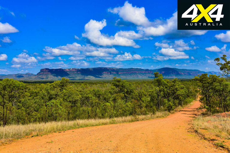
MOUNT Mulligan is a free-standing, rock-and-sandstone massif that stands 800 metres tall. It is 18km long and 6.5km wide and runs in a north-south direction. The indigenous owners call it Ngarrabullgan – though, others claim it is Woothakata – and it has high value as a site of significance.
13
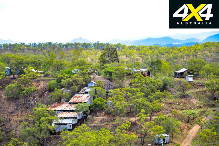
Our next stop was the Mount Mulligan Mine. The entrance, past the old hospital, is now closed and the only entrance to the old mine is near the cemetery. Coal was discovered on its eastern side in 1907, the same year that James Mulligan died and was buried at Mount Molloy.
It was the only coal field in the far north, and mining commenced there soon after. The town of Mount Mulligan was laid out on August 5, 1913, and a railway from Dimbulah reached the mine in 1914. The coal was mined from a shaft dug into the lower Permian layer within the cliff face, and it supplied the Queensland railways.
On the morning of September 19, 1921, school children sang the national anthem as the Australian flag was raised. Suddenly, there was a huge explosion and a speeding, billowing black cloud shot out of the mineshaft about one kilometre away. The kids screamed in terror as they were flung to the ground.
13
At that very moment every schoolchild (and their siblings at home) became instant orphans and their mothers became instant widows, as workers died in the coal-dust explosion. In all, 75 men were killed; and one can only image the grief those poor women and children endured.
The blast carried all the way to Mount Molloy and Dimbulah, and it was said it was even heard at Irvinebank and Chillagoe. Help arrived within hours, but there was nothing to be done. All but one body was recovered and buried at a new purpose-made cemetery. The mine re-opened in 1923 and was worked until 1957, when dieselisation of the railways forced its closure.
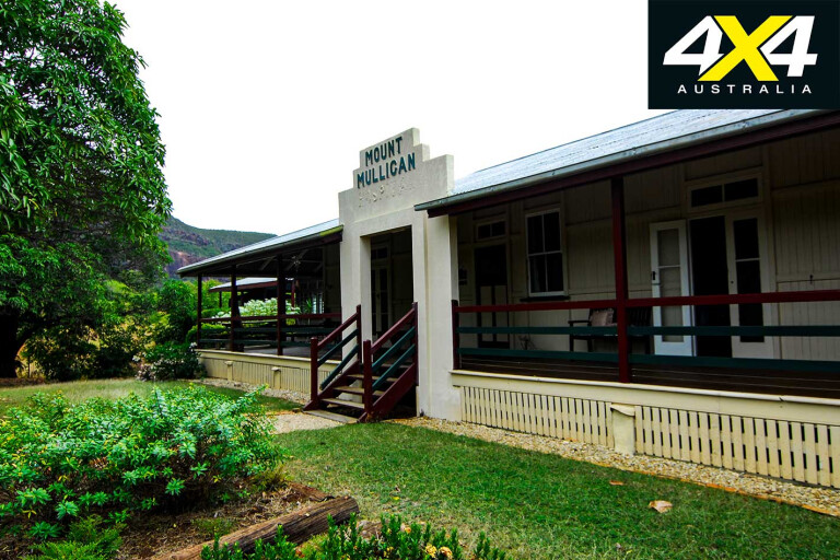
Townhouses and other buildings were dismantled and moved elsewhere by rail, as was the railway; although, the hospital remained to be used as a station homestead. At its height Mount Mulligan had a population of 300 people.
13
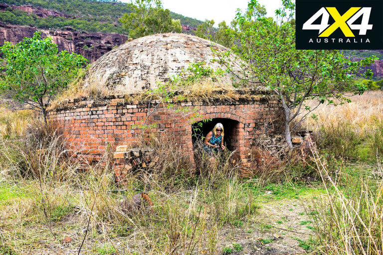
Apart from the chimney, brick kiln and remnants of concrete blocks, stumps and rusted water tanks, little else remains of the mine and township. All of the main cemeteries in the region are maintained by the Cairns 4WD Club.
We continued on to catch-up with old mate Wayne Peacock, who contracts for the Kondoparinga traditional owners to book, manage and control designated camping areas and visitors on the property. He lives on the other side of the Hodgkinson River, which was running high.
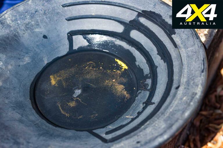
As I was unsure of its height and best place to cross I called Wayne on the radio, and he soon turned up and drove across to show me the way. Wayne is a keen prospector and was more than happy to show off his collection of old relics and specks of gold.
In fact, most campers are fossickers seeking gold, and, despite modern methods of extraction in recent years, plenty of gold remains in this country; both panning and detecting still bring rewards to those who work at it.
13
The camps are located on the eastern side of the main track to the Cooktown Crossing. The Mareeba-based T/Os have future plans to open up other areas of this vast station for visitors, including a walking track up to the top of Mount Mulligan.
There is also a free campground on the crossing, which is on Brookfield Station, owned by the Australian Conservatory. It’s an Australian taxpayer-gifted property, which means no access unless you’re a member.
MORE4x4 Explore
If Kondaparinga politics run smoothly, some big changes may happen should the T/Os continue on their path to develop this beautiful station for environmentally friendly camping and fossicking. There is still gold in “them thar hills”, but inviting others to share this wealth of wilderness may be a bigger money spinner than gold.
13
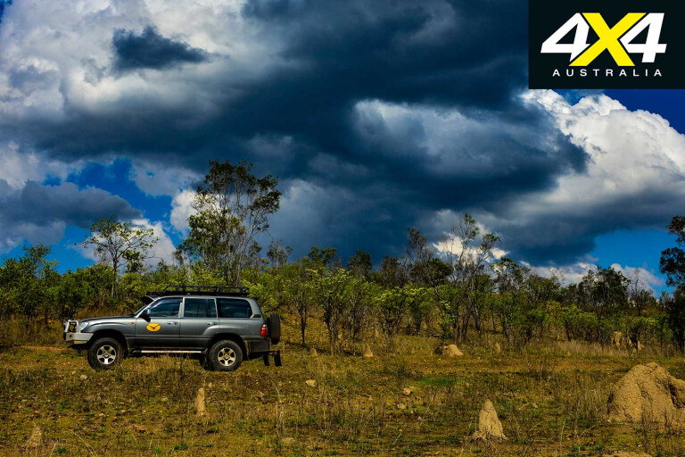
By late afternoon, we decided to move on as thunder rumbled over the Mount Mulligan massif, while dark storm clouds obliterated the western horizon. The weather was closing in fast, with continuous thunder rumbling beyond the surrounding hills.
Wayne told us that the Cooktown Crossing was running quite high, so we turned back the way we had come to see it all again. By the time we reached Dimbulah the southern hills of the Great Divide had vanished under black, lightning-troubled clouds. The wet season was nigh, but what a great day it had been indeed.
Please enable JavaScript to view the comments powered by Disqus.
COMMENTS