Explore SA
Gallery2
Anyone with a yearn for 4x4 adventure could do worse than check out the Border Track in South Australia’s Ngarkat Conservation Park, a remote and surprisingly beautiful part of that state’s Mallee Country.
As its name suggests, the Border Track follows more than 50km of the fence line marking the boundary between Victoria and South Australia. Surveyed in 1850 the border was intended to follow the line of 141 east longitude. The privations suffered by the surveyors who cut this line through what is largely waterless country rivalled the exploits of Burke and Wills, and the party almost lost their lives on three occasions.
One horrific encounter with a bushfire saw one of the surveyors climb down a well to avoid the flames, only to be almost burnt to death by boiling fat dripping down from his dead horse lying in the flames above.
 The surveyors started from a marker on a beach near the Gawler River in the south, but on reaching the Murray River in the north they found, to their horror, that their line was 3.6km to the west of the border with New South Wales. One of the surveyors must have been named Murphy because they marked the border with timber stakes in mounds of soil, and shortly after the survey was completed a huge bushfire swept through the Mallee, destroying 200km of markers.
With the country dry and denuded, the mounds (which were principally sand) simply blew away leaving no trace of the surveyors’ herculean efforts. The survey notes were also lost and 64 years of legal argument ensued between Victoria and South Australia over this ribbon of disputed no man’s land. The argument was finally settled in Victoria’s favour in 1914 by London’s Privy Council.
 With many tracts of land adjoining the incorrectly marked border having been bought and sold over the intervening years, moving the border was simply too problematic. While the true reason for the survey error was never made public, it seems the most likely cause was the incorrect location of the starting point on the Gawler River.
Today, much of the Ngarkat Conservation Park probably still looks as it did in the 1850s despite failed attempts at farming the land in years gone by. Driving into the park from Bordertown by way of the sealed Ngarkat Highway, it’s difficult not to be underwhelmed.
The flat, sandy country is covered by a uniform cloak of olive green scrub just a few metres high, punctuated here and there by the occasional taller eucalypt. However, someone once said “never judge a book by its cover” and Ngarkat is no exception as the scrub comprises a wide range of flora.
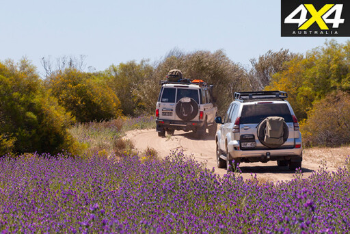 After significant rain, quite impressive stands of wildflowers can spring up to paint the otherwise drab native bush with splashes of vibrant colour. Apart from the occasional kangaroo or emu grazing on the roadside, or delicate tracks in the sand, there is little to be seen in the way of animal life, probably due to the arid climate and lack of surface water.
Birds are another matter altogether and campers can expect to be woken at first light by a cacophony of bird calls as the avian residents proclaim their territorial ownership to all and sundry.
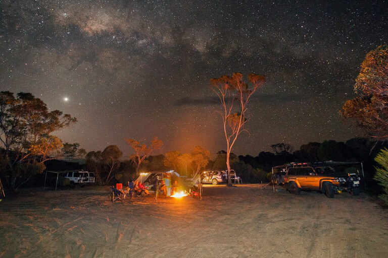
A good place to start exploration of the Park is Pertendi Hut just off the Ngarkat Highway. This restored shepherd’s hut, being little more than four concrete walls, certainly won’t win any architectural prizes; however, it would offer welcome protection in inclement weather. One thing SA Parks seems to generally do better than its interstate counterparts is the provision and maintenance of campground facilities.
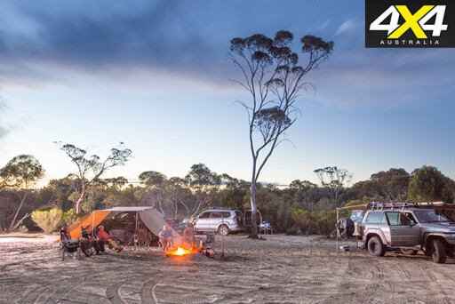 While probably not to be taken literally, the Pertendi Hut facilities could be said to be “clean enough to eat your lunch off”. Near the hut a small grove of (introduced) pines provides campers with protection from the elements,while a more expansive cleared area is available for larger groups.
Fire rings are provided, but the park is subject to a blanket fire ban between November and April. From 2017 SA Parks are planning to adopt the absurd system of visitors having to pre-purchase entry and camping permits online. No doubt they will be installing satellite Wi-Fi at all park entry points to enable visitors to comply!
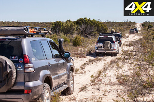
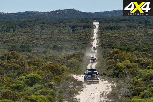
From Pertendi Hut a track east to the border intersects with Centre Track, which is an easy run to the northern boundary of the park near Pine Hut Soak campsite and the start of the Border Track. Tracks in the park are largely unmaintained and, while not particularly corrugated, the undulations worn into the sand (not surprisingly) seem to resonate perfectly with 4x4 suspensions at anything above 15 to 20km/h.
 Anyone who has driven the Simpson Desert will soon see many similarities in required driving technique. It takes a little while to get your eye in and be able to pick which undulations are likely to see vehicle passengers thrown upwards, only to crash back down just in time to meet the vehicle’s next leap into the air. In short, the park’s 4x4 tracks are long and slow with some added rock and roll – basically a rollicking beat from start to finish.
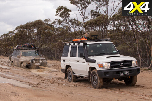
The northern half of the Border Track is one way to avoid the possibility of collision between oncoming vehicles on the narrow sandy track that has numerous dunes with blind crests. With tyre pressures reduced to 15psi or less the driving is relatively easy, but a high-clearance 4x4 is a definite advantage. As are good tyres to cope with the occasional deep, soft sand.
During long weekends and school holidays the track experiences a surge in traffic and the face of many dunes can be quite chopped up from preceding drivers who think the only way to the top is by pedal to the metal. In hot, dry weather a degree of momentum may be required, but the track is only open during the cooler and wetter months. If the sand is at all moist most 4x4s won’t experience any difficulty climbing the dunes.
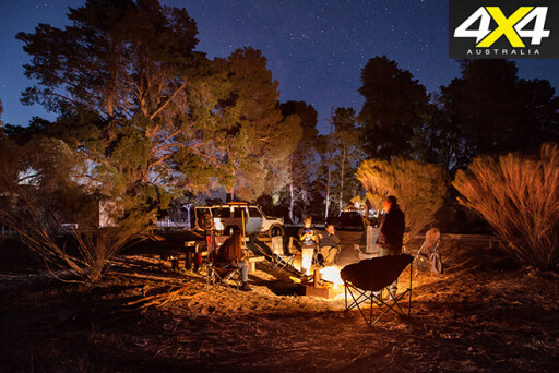
 The Border Track can be driven in several hours, but to properly take in the beauty of the park this is a journey best done over a couple of days. That being said, there are only three small campsites available to travellers, and severe penalties exist for anyone caught camping outside of these designated areas. The moral of the story is simple: make camp early or risk missing out and having to face several hours more driving.
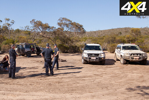
Penalties can be severe for those who disobey the regulations. If you think you’re unlikely to be caught out in such a remote area, be warned that both police and parks officers can drop in at any time – as testified to by a 4pm visit to your correspondent’s campsite at The Gums by two police 4x4s.
Two of the track’s campsites, The Pines and The Gums, arguably offer more pleasant camping opportunities than Doggers Hut much further to the south; however, none of the three provide any facilities. The Gums, being roughly halfway along the track and tucked away a couple of hundred metres down a side track, is perhaps the preferred place to overnight.
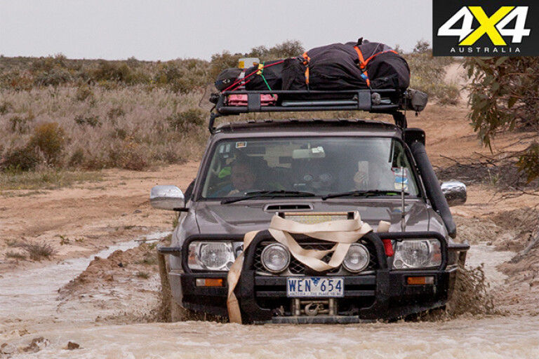
 From the southern end of the track’s one-way section visitors have a choice of travelling west back to Pertendi Hut and the Ngarkat Highway, or continue south out of the park and turn east into Victoria to follow the southern boundary of the Big Desert National Park. Here sand begins to give way to patches of clay and, after rain, the mud larks will be in seventh heaven as they navigate several large bog holes found along here.
This track ends at the Nhill to Murrayville Road, and for anyone whose appetite for sand driving has not been fully sated there is a very expansive campground at Big Billy 40km to the north, where a number of large dunes can be found. Be warned that with Big Billy having 2WD access you can expect it to be very busy during holiday periods.
The Border Track offers an interesting and at times technically challenging 4x4 driving experience less than a day’s drive from either Melbourne or Adelaide.
2
TRAVEL PLANNER
WHERE
Ngarkat Conservation Park is located 70km north of Bordertown and is approximately four hours travelling time from Adelaide or six hours from Melbourne.
WHEN TO TRAVEL
The Border Track is closed from November to April. As summer temperatures regularly exceed 40ºC, be sure to visit the park during the cooler months.
STAYING THERE
Park entry fees of $10 per vehicle and a camping fee of $12 per vehicle per night apply and are paid on entry. Pine Hut Soak and Pertendi Hut campsites have toilets. Patchy reception can be found near the Park’s northern and southern extremities, but anyone needing a mobile fix can get one in the middle of the Border Track at Hensley Trig, the park’s highest point. In warm weather flies can be chronic, making fly veils a valuable bit of kit.
 SUPPLIES
The nearest sources of fuel and supplies are Bordertown in the south or Pinnaroo in the north, so make sure you plan ahead before the trip.
ROAD CONDITIONS
All tracks within the park are largely unmaintained requiring low tyre pressures (15-20psi) and high clearance 4x4s to cope with sections of deep, soft sand. Carrying a shovel, recovery equipment and traction aids such as MaxTrax is highly recommended. The rough and bumpy Border Track is unsuitable for
camper trailers.
MAPS
Good quality paper maps and a 4x4 GPS are recommended.
CONTACTS
SA Department for Environment and Heritage, Lameroo SA
Phone: (08) 8576 3690 Website: National Parks, SA
What's your next off-road destination? Find out and explore.
Please enable JavaScript to view the comments powered by Disqus.
COMMENTS