Explore VIC
Gallery22
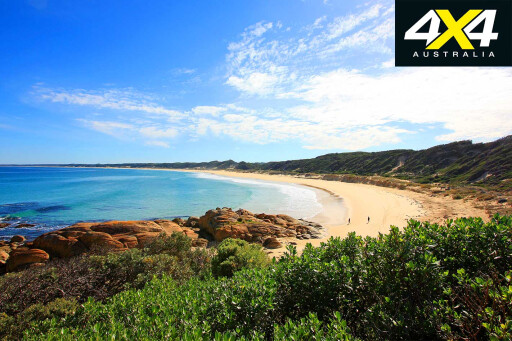
The Wilderness Coast is an apt description for the far eastern reaches of the Victorian coastline, with more vegetation than cleared land and significant wilderness tracts that are havens for plants and wildlife. With both cool and warm temperate rainforests, unspoilt beaches, coastal heaths and plentiful native plants, it’s a magical area to explore.
This feature was originally published in 4x4 Australia magazine's March 2011 issue
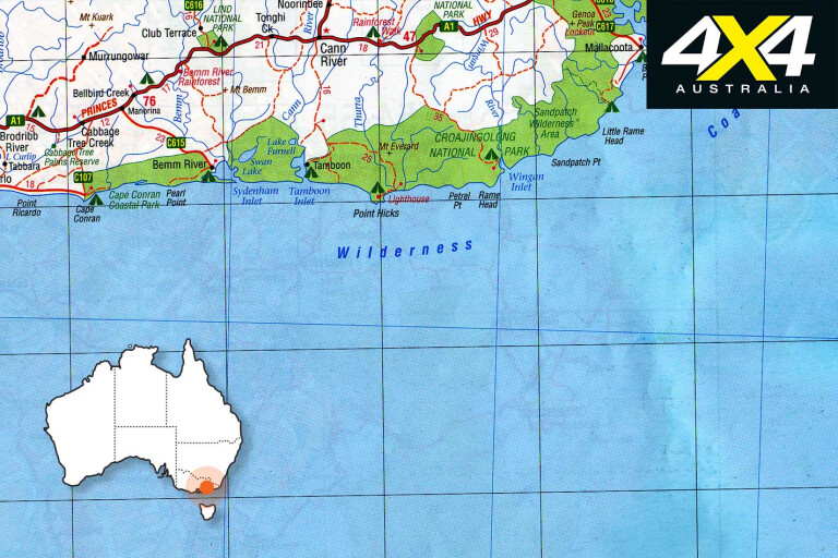
The Wilderness Coast extends from Cape Conran in far East Gippsland to the NSW border; about 100km of rugged coastline. Its seaside bush campsites are the pinnacle of tranquillity in a region with rainforest walks, four-wheel driving and a host of beach activities.
 Cape Conran Coastal Park attracts a thousand visitors a day in summer to the magnificent coastline for surfing, diving, snorkelling, rock pooling, boating, swimming, beach walks, or just relaxing. It is one of few areas managed by Parks Victoria that allows our canine counterparts to tag along.
Bush camping at Banksia Bluff Camp provides a unique beachside experience – a septic system featuring flushing toilets, and shower stalls that allow you to add your own hot water.
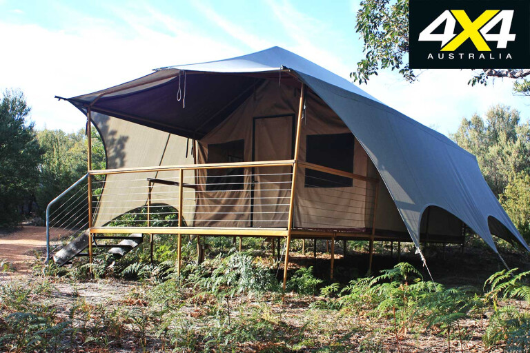
As an alternative to camping, the park has timber cabins and wilderness retreats, the latter being the closest thing I’ve seen to five-star camping. Picture a safari tent on stilts, with a hardwood floor, queen-size bed, plush linen and big cuddly towels. The retreats are ideal for couples, but can sleep four people at a pinch. They’re tucked neatly into the bushland away from the camping area, with easy beach access.
Short beach and bush walks beckon you to discover the wilderness elements of the park. The Heathland Walk steps off from the campground and features grass trees, coastal heath, and a variety of birds and other wildlife.
22
The East Cape Boardwalk starts at Sailors Grave on East Cape Beach and traces the rocky headland, scattered with ocean kelp and sponges. The East Cape Nature Trail is another short walk that includes interpretive signs describing some of the birds, animals and plants of the area and how to identify their tracks.
There are a number of longer walks, such as the 14km return hike to the freshwater Dock Inlet, separated from the sea by a dune barrier, or further afield to Pearl Point (25km), a popular fishing spot.
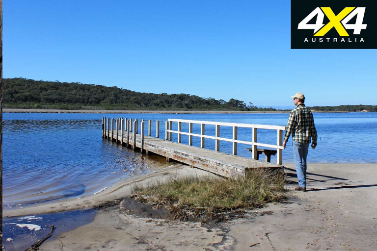
Yeerung Gorge is a jewel of the cape, with its rock pools fed by the Yeerung River. South of the gorge, a walking trail follows the edge of the estuary to the sea. From the camp, the gorge can be
accessed from East Yeerung Track or the Old Coast Road from the north; both are subject to seasonal closure.
22
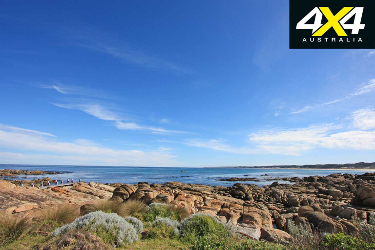
Off the coast, you’ll see whales between May and October as they migrate north. Dolphins and seals are also popular. Beware Reef Marine Sanctuary (220ha), 5km offshore, has granite reefs that rise 30m off the sea floor. Bull kelp hides a diversity of corals, sponges and anemones and many species of fish, making it a diver’s delight. The fish are protected in the marine reserve, so it’s observing only, folks.
On the land, there are a wide variety of birds, potoroos, bandicoots, wallabies, wombats and goannas. The goannas often skulk around the campsites in summer looking for eggs.
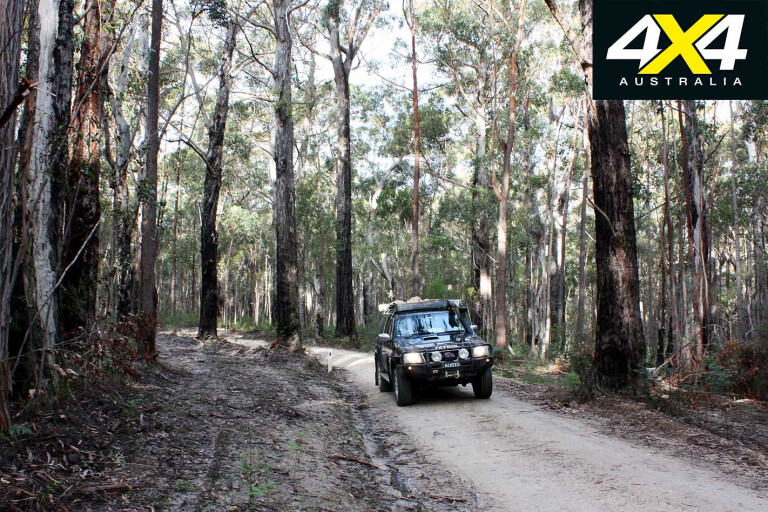
There are a number of great back roads in the area to explore. They are mainly unsealed, documented in the excellent Far East Gippsland Back Roads Touring Guide, a joint venture between Parks Victoria, the Department of Sustainability and Environment and 4WD Victoria.
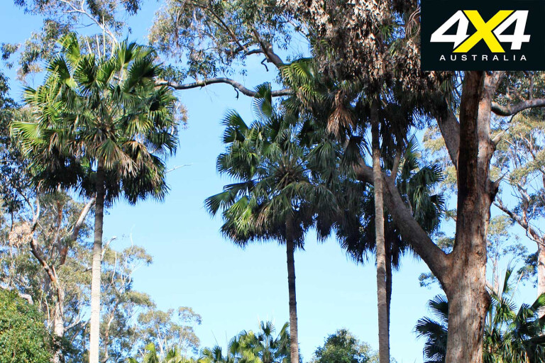
Cabbage Tree Creek Flora Reserve is worth a visit, the forest dotted with examples of the palm that gives the place its name. They are normally found in NSW and Queensland, this being the only known location in Victoria.
22
The reserve has picnic tables in a grassed area under a light tree canopy, making a perfect location for morning tea or lunch. Reach it via Palms Track, off the Marlo-Cabbage Tree road or from the Princes Highway. The Bemm River Scenic Reserve has a meandering one kilometre rainforest walk, crossing two suspension bridges en route.
Onward towards Mallacoota, the Princes Highway reaches Cann River, the major gateway to Croajingolong National Park and the turn-off to Thurra River and Mueller Inlet campgrounds, via Tamboon and Point Hicks roads Tamboon Road is a narrow bitumen affair weaving through Tamboon State Forest, eventually giving way to unsealed road. It deteriorates as it closes in on Point Hicks and enters Croajingolong NP, with corrugations the common theme.
Point Hicks was the first part of the Australian mainland sighted by Captain Cook in the Endeavour in 1770. He named it after his first lieutenant, Zachary Hicks. There was some dispute about what Cook actually saw, as George Bass was unable to identify the point when he sailed past in 1797. As such, the area was then named Cape Everard. However, it was renamed Point Hicks in 1970.
22
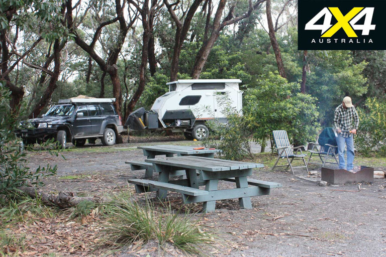
Thurra River and Mueller Inlet are part of a private leasehold, run independently within Croajingolong. Thurra River is the largest bush campground in the region, with 46 sites that vary in size and suitability for tents, campervans and caravans.
Shade provided by the tea-tree canopy makes it ideal for the warmer months – but not so great when the mercury drops. Finding a patch of sunlight for a solar panel or two is a challenge, and generators are not permitted.
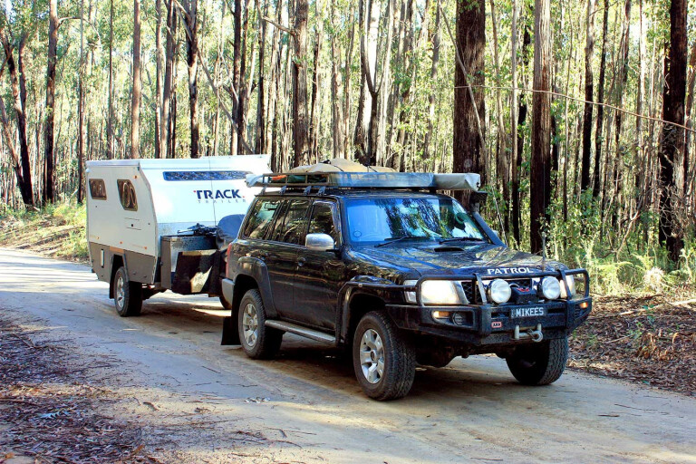
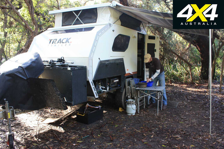
The tea-tree woodlands also make many of the campsites unsuitable for caravans. Our 16-foot (4.8m) Topaz pop-up van squeezed in okay, but anything bigger would prove tricky. Most of the sites border the beach, with the sounds of the Tasman’s pounding surf lulling you into deep relaxation.
22
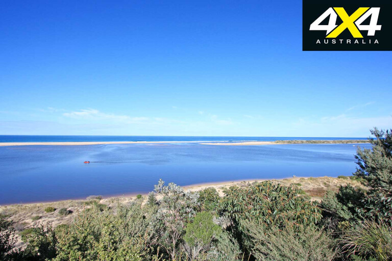
By comparison, Mueller Inlet campground is perched directly on the inlet, with direct water access for each of its eight sites. There’s little room to manoeuvre a camper or van. The inlet is closed to the sea, creating an ideal location for flat-water canoeing without tidal or current impacts. Canoes can be hired from the lighthouse caretaker and dropped off at the inlet.
There are a number of walks at Thurra River. The Dunes Walk is the highlight, rising 145m on Victoria’s highest dunes; it’s uphill for most of the journey. The path treks through coastal banksia woodlands, and native wildflowers.
You could easily spend the best part of a day exploring this amazing area. The walking track spears out of the growth on the verge of the dunes, with the highest peaks at least a kilometre or so further afield. We found dingo tracks on the sand and peculiar dark circular patterns that, on closer examination, appeared to be ash fallout from a bushfire. Alas, no evidence of extraterrestrial activities!
In the warmer months, you can drop down the dunes and walk the path of the shallow Thurra River back to camp. It can be very warm out on the dunes, so take plenty of food, water and sun protection.

22
Other walks here include the Saros wreck, the jetty remnants, Sledge Track from which supplies were ferried to the mainland years ago, and the Mueller Inlet beach walk. Mt Everard lookout is accessed from Point Hicks Road via Cicada Track; subject to seasonal closure. The track winds through burnt eucalyptus forest, dotted with termite mounds and fresh forest-floor regrowth.
In season, the Cicada Track weaves its way to Wingan Inlet, with its campground set in the forest. In the colder months, access is from the Princes Highway via West Wingan Road or East Wingan/Wingan Link roads.
Following West Wingan Road, it’s about an hour from the highway, the road passing through Alfred National Park, Wingan State Forest and finally entering Croajingolong NP. There are logging trucks, so keep the UHF on channel 40 or the signposted channel and transmit occasionally to warn others of your proximity.
MOREUHF radios
The varied plantlife at the Wingan Inlet campsite gives it a magical quality. The sites are generally larger than Thurra River, with more sunlight to charge those solar panels, but the campground circuit is similarly tight, restricting manoeuvrability for larger vehicles and trailers. The West Wingan Road is designated as unsuitable for caravans, but we found it easy going. The track does become much narrower as you approach the campsite, but otherwise it is standard off-road fare.
22
Following the access track to the inlet, the water is stained brown by tannin leeched from the tea tree leaves. It doesn’t look altogether appealing, but it’s safe for paddling around in. Like Mueller Inlet, no campfires are permitted, only gas appliances.
The campground has a jetty and beach-like surroundings where you can drop in a tinny. Boat engines are limited to 20 horsepower and speeds restricted to five knots to reduce shoreline erosion. Fresh, untreated water is pumped to the day visitor area, or you can wander down Boundary Track to the Wingan River for fresh supplies.
If the kids want to wander along the beach and collect shells and other ocean flotsam, the only option is Fly Cove, a 3km return walk. Other walks include Elusive Lake, a fresh water lake with a sandy beach, Wingan rapids, or the stream gauge off Boundary Track.
For the ultimate kayaking adventure, paddle up the Wingan River – its 6km of flat water providing views of the rainforest, and granite outcrops forming rapids and small waterfalls.
22
In the warmer months, you can make your way through forest back roads to Mallacoota, via the Wingan Link Road, Hard to Seek Track, Stony Peak Road, Betka and Centre Tracks. The creek crossings on Hard to Seek Track and Betka Track are subject to seasonal closure.
Otherwise, the family holiday mecca of Mallacoota is accessible from the blacktop along the Princes Highway. I remember holidaying at Mallacoota as a child with my family; a tinny propped on the roof of the Kingswood, and the Jayco trailing along behind. We’d fish by day and prawn by torchlight at night. Nothing much has changed in the last 30 years.
The Foreshore Caravan Park still has pride of place overlooking the inlet, with no less than 710 sites. Fish, including leatherjacket, flathead, bream, snapper, salmon and tailor, can be caught off the numerous platforms around the inlet. And the locals love to talk up the lifestyle of such a great location. The braggers!
22
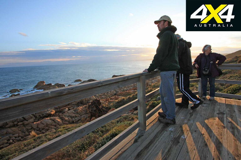
Some of the best views of the lakes are at the Bastion Point viewing platform, Captain Stevensons Point in Foreshore Caravan Park, or along Lakeside Drive around the lake; turn right wherever possible to remain on the water’s edge. Climbing Karbeethong Road, beyond the jetty of the same name, provides an elevated perspective and views of the palatial abalone divers’ homes.
MOREExplore
Bush camping is prohibited around Mallacoota, but Shipwreck Creek, named after the 20-odd wrecks along this stretch of coast, is only 15km away and has five sites. It is easily accessed via Betka Road and Centre Track, which parallel the beach before weaving through a tall forest. Once in the forest, signs warn of a rough track ahead, although we found it easy going apart from the soft verges.
Beyond the Wilderness Coast there are myriad green family adventures ripe for the picking. There’s Snowy River NP, deep gorges and forests; Errinundra NP, with its plateau and granite outcrops; and the lesser-known Coopracambra NP, featuring cascading waterfalls and more greenery.
22
If you thought the Victorian High Country offered the pinnacle family four-wheel driving, a few weeks exploring far East Gippsland will quickly challenge that.
Travel Planner
WHERE
The Wilderness Coast is in Far East Gippsland, 450km east of Melbourne. The best times to visit are November to May, when all the tracks are open (access to the camps is allowed all year). The Wilderness Coast often records Victoria’s highest temperatures and is warmer than you might imagine, even during winter.
22
CAMPING
There are dozens of options. Be sure to check prices and availability before arriving. A ballot system applies to many campsites during the peak periods of Christmas, Easter and some public holidays. The pricing range is for low and high seasons.
WHAT TO TAKE
Insect repellent, drinking water, fishing gear and firewood in season.
SUPPLIES
Orbost, Cann River and Mallacoota provide most. Newmerella and Marlo have basic supplies only. Fuel is available from Orbost, Marlo, Cann River and Mallacoota.
TRIP STANDARD
Sealed roads to Marlo, near Cape Conran. Good unsealed roads within the Banksia Bluff Camping Area and to the Cabbage Tree Creek Flora. Roads to Thurra River, Mueller Inlet, Tamboon Inlet and Wingan Inlet are unsealed and badly corrugated in some sections. The back road touring options are mainly easy four-wheel driving.
MAPS AND GUIDES
Rooftop’s Cann River-Orbost-Delegate Adventure Map and Mallacoota-Merimbula Adventure Map.
Walking the Wilderness Coast by Peter Cook and Chris Dowd, Wildcoast Publications.
Far East Gippsland Back Roads Touring Guide, Department of Sustainability and Environment (DSE).
CONTACTS AND INFORMATION
Cape Conran Coastal Park Cabins and Camping – 03 5154 8438, conran.net.au.
Point Hicks Lighthouse – 03 5158 4268
Lakes Entrance Visitor Information Centre – 1800 637 060, lakesvic@egipps.vic.gov.au.
DSE – 136 186, customer.service@dse.vic.gov.au.
Please enable JavaScript to view the comments powered by Disqus.
COMMENTS